Rest of the work week: A couple days of quiet, then a stormy Friday

After a day of weather that went more or less as advertised, we get a couple days to dry out before another round of showers and thunderstorms — and maybe some more severe weather — arrives on Friday.
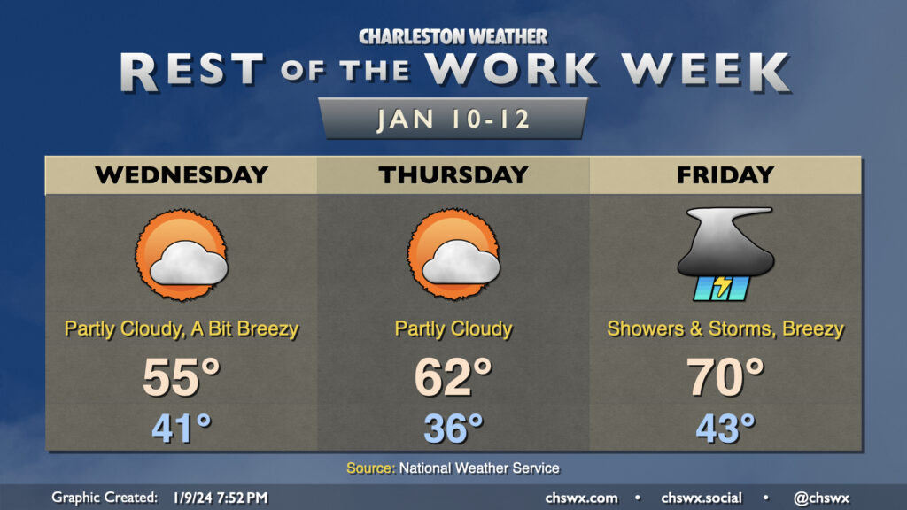
We will stay breezy Wednesday, particularly in the morning, as cooler and drier air blows into the area behind a cold front. We start the day in the low 40s and warm to the mid-50s in the afternoon. A few clouds will be around, but overall it’ll be much sunnier than Tuesday. (Not hard to do!)
Thursday will feature calmer winds and a chillier start. We’ll begin the day in the mid-30s before warming to the low 60s in the afternoon under partly cloudy skies. It should be a fairly quiet, nice day of weather overall.
The quiet doesn’t last, though, as another storm system affects the area on Friday. While it won’t be as windy of a system as Tuesday’s was, it will still bring with it a fairly well-sheared environment which, if paired with enough instability, could yield another round of severe weather. The Storm Prediction Center has the area outlined in a 15% severe weather risk in the Day 4 outlook; we’ll see how this evolves as the rest of the week wears on. For now, though, don’t let the weather radio stray too far…we might need it again later this week.
Tuesday’s top gusts

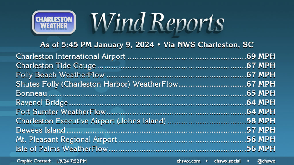
Tuesday’s winds were as advertised: Numerous gusts over 50 MPH were recorded across the area, with thunderstorm gusts approaching 70 MPH as the squall line came through the metro. Many, many trees were brought down, and a tractor trailer was even flipped on the Ravenel Bridge, which sent the bridges into Code Red status for a time — meaning patrols on the bridges essentially ceased. The good news is that there were no tornadoes in the Tri-County area — we’ll take whatever wins we can get from this one.
Here’s the full list of gusts from NWS Charleston from around the metro and its area of responsibility, including parts of Georgia:
Location                     Speed     Time/Date       Provider
Buoy 41004                   69 MPH    0600 PM 01/09   NDBC
Charleston Intl Airport      69 MPH    0415 PM 01/09   ASOS
Sapelo Island NERRS          68 MPH    0315 PM 01/09   NERRS
Charleston, SC               67 MPH    0418 PM 01/09   NOS-NWLON
Folly Beach, SC              67 MPH    0515 PM 01/09   WXFLOW
Shutes Folly                 67 MPH    0522 PM 01/09   WXFLOW
Bonneau                      65 MPH    1245 PM 01/09   CWOP
1.1 SW Remleys Point (SCDOT) 64 MPH    0415 PM 01/09   MESOWEST
Fort Sumter                  64 MPH    0412 PM 01/09   WXFLOW
2.2 NW Charleston (SCDOT)    60 MPH    0416 PM 01/09   MESOWEST
Battery Point                60 MPH    0414 PM 01/09   WXFLOW
Montgomery                   59 MPH    0335 PM 01/09   CWOP
Green Pond                   58 MPH    0145 PM 01/09   DAVIS
Charleston Exec Arpt         58 MPH    0415 PM 01/09   AWOS
DEWEES ISLAND                57 MPH    0425 PM 01/09   CWOP
Mount Pleasant Rgn Arpt      56 MPH    0415 PM 01/09   AWOS
Beaufort MCAS                56 MPH    0307 PM 01/09   AWOS
Beaufort WxFlow              56 MPH    0344 PM 01/09   WXFLOW
Isle of Palms                56 MPH    0525 PM 01/09   WXFLOW
SULLIVAN'S ISLAND            56 MPH    0414 PM 01/09   WXFLOW
Botany Bay Heritage Preserve 55 MPH    0400 PM 01/09   MESOWEST
Fort Pulaski                 55 MPH    0312 PM 01/09   NOS-NWLON
Beaufort Exec Arpt           53 MPH    0355 PM 01/09   AWOS
Savannah Intl Airport        52 MPH    0300 PM 01/09   ASOS
Harleyville - Dorchester Mes 50 MPH    0215 PM 01/09   CWOP
MONCKS CORNER                49 MPH    0329 PM 01/09   CWOP
Moncks Corner Aprt           49 MPH    0435 PM 01/09   AWOS
St. Phillips Island-Scprt Do 49 MPH    0338 PM 01/09   MESOWEST
Savannah                     48 MPH    0345 PM 01/09   CWOP
Walterboro Aprt              48 MPH    0235 PM 01/09   AWOS
Capers Nearshore Buoy        47 MPH    0508 PM 01/09   NDBC
Fripp Nearshore Buoy         47 MPH    0408 PM 01/09   NDBC
Sullivan'S Island            47 MPH    0405 PM 01/09   DAVIS
Mount Pleasant               47 MPH    0415 PM 01/09   CWOP
Sainte George - Dorchester M 47 MPH    0215 PM 01/09   CWOP
West Ashley (WEATHERSTEM)    46 MPH    0500 PM 01/09   MESOWEST
Fort Stewart                 46 MPH    1039 AM 01/09   CWOP
I-95 Chatham Weigh Station   46 MPH    1240 PM 01/09   MESOWEST
Savannah NWR                 46 MPH    0323 PM 01/09   RAWS
2.4 SE Burton (WEATHERSTEM)  45 MPH    0420 PM 01/09   MESOWEST
Mount Pleasant               45 MPH    0438 PM 01/09   CWOP
Ridgeville - Dorchester Meso 44 MPH    1215 PM 01/09   CWOP
Buoy 41008                   43 MPH    0440 PM 01/09   NDBC
Huger 7.7S - Bridges at Seve 43 MPH    0439 PM 01/09   CWOP
Allendale Cnty Aprt          43 MPH    1115 AM 01/09   AWOS
Summerville Aprt             41 MPH    0435 PM 01/09   AWOS
North Tybee Island           41 MPH    0342 PM 01/09   WXFLOW
Charleston                   40 MPH    0445 PM 01/09   DAVIS
Lawson                       40 MPH    0104 PM 01/09   RAWS
Summerville                  40 MPH    0233 PM 01/09   CWOP
SAINT GEORGE                 40 MPH    0115 PM 01/09   CWOP
North Charleston - Dorcheste 40 MPH    0330 PM 01/09   CWOP
Reidsville Airport           40 MPH    1235 PM 01/09   AWOS
Swinton Smith Field At Reids 40 MPH    1235 PM 01/09   MESOWEST
Summerville                  39 MPH    0314 PM 01/09   CWOP
Ravenel                      39 MPH    0339 PM 01/09   CWOP
Ravenel - Dorchester Mesonet 39 MPH    0415 PM 01/09   CWOP
Hilton Head Island           38 MPH    0325 PM 01/09   DAVIS
Mount Pleasant               38 MPH    0530 PM 01/09   DAVIS
WADMALAW ISLAND              38 MPH    0345 PM 01/09   CWOP
Statesboro Airport           38 MPH    1055 AM 01/09   AWOS
Glennville                   38 MPH    1245 PM 01/09   UGA
Millen Airport               37 MPH    1135 AM 01/09   AWOS
Millen Airport               37 MPH    1135 AM 01/09   MESOWEST
Walterboro                   37 MPH    0507 PM 01/09   RAWS
Daniel Island                36 MPH    0356 PM 01/09   CWOP
Claxton Evans Co Aprt        36 MPH    0335 PM 01/09   AWOS
Hilton Head Airport          36 MPH    0250 PM 01/09   AWOS
Fort Stewart                 36 MPH    0249 PM 01/09   AWOS
2 SW Metter                  36 MPH    1135 AM 01/09   AWOS
Metter Municipal Airport     36 MPH    1135 AM 01/09   MESOWEST
North Charleston             35 MPH    0515 PM 01/09   DAVIS
Hilton Head Island           35 MPH    0345 PM 01/09   CWOP
Fort Stewart                 35 MPH    1140 AM 01/09   AWOS
Follow my Charleston Weather updates on Mastodon, Bluesky, Instagram, Facebook, or directly in a feed reader. Do you like what you see here? Please consider supporting my independent, hype-averse weather journalism and become a supporter on Patreon for a broader look at all things #chswx!