Thursday: A quiet day with a bit of a chill ahead of another round of storms on Friday
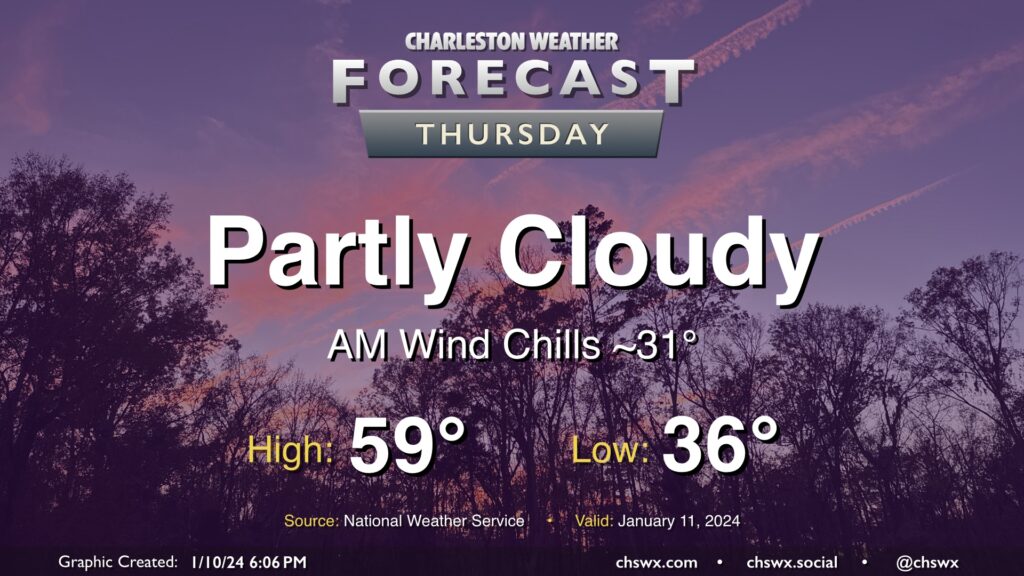
High pressure will be in control for one more day on Thursday. We’ll start the day a little cooler than we did on Wednesday, and certainly much less windy, too. However, a light breeze will still make lows in the mid-30s feel closer to freezing. Temperatures will head to the upper 50s in the afternoon under a mix of sun and cloud cover.
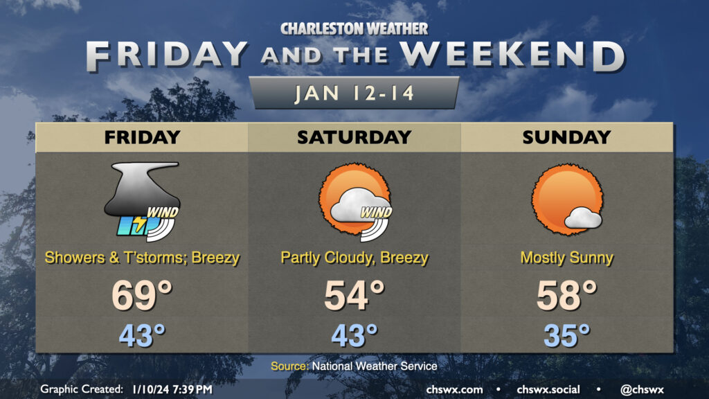
The tranquil weather does not last, though, as another powerful storm system develops and moves into the Great Lakes region. The resulting surface low will drive another cold front through the area late Friday, bringing another windy day and a risk for severe weather to the region. It will be another day to pay close attention to the forecast given the potential for some strong wind gusts.
Expect rain to be ongoing as we wake up Friday morning as a warm front lifts north of the area. Temperatures will start in the low 40s, warming to the upper 60s by the afternoon. We should see wind speeds come back up again, and 30-40 MPH wind gusts outside of storms are a possibility. However, we should not see a repeat of the high wind warning-level conditions from Tuesday.
Once again, wind fields look fairly impressive, though not quite to the degree that Tuesday’s did. Still, there will be upwards of 70 knots of shear for storms to work with, with the question once again being how much instability will be available. Generally speaking, it looks like there will be more precipitation throughout the day Friday than we saw on Tuesday, which should put a bit more of a governor on the severe threat. However, there will still be excellent moisture transport, which may bring in just enough instability for a few storms to take advantage of the strong shear. Damaging wind gusts and a tornado or two are once again the main concerns with thunderstorms on Friday. The greatest risk for severe storms looks to be found along and inland of 17-A, but we’ll see how this ultimately evolves, though. Stay tuned to forecast updates throughout the day Thursday as Friday’s risk is fine-tuned.
The weather quiets down and cools off for Saturday and Sunday, heading into the long Martin Luther King, Jr. Day weekend. Saturday will be another breezy day as cooler air works into the area; expect highs to peak in the mid-50s after a low 40s start. Sunday starts in the mid-30s, while warming to the upper 50s in the afternoon under mostly sunny skies. The next front could bring some precipitation to the area on Monday, followed by a cold snap — think lows in the 20s by Wednesday — thereafter.
Follow my Charleston Weather updates on Mastodon, Bluesky, Instagram, Facebook, or directly in a feed reader. Do you like what you see here? Please consider supporting my independent, hype-averse weather journalism and become a supporter on Patreon for a broader look at all things #chswx!