Rest of the work week: A quick cold shot indicates what’s to come this weekend
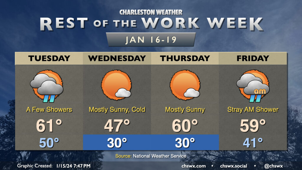
Temperatures will be somewhat fickle this week as a series of fronts move through the area. Tuesday will trend on the warm side, with lows around 50° to start the day heading into the low 60s in the afternoon as the first front moves by. A few showers will be possible along and ahead of the front, primarily midday through early evening. They won’t have much moisture to wring out, so expect the showers to be on the light side. From there, temperatures will plummet overnight.
We will most definitely know that a front has come through Wednesday morning. We’ll wake up to subfreezing temperatures across much of the area away from the immediate coast; breezy northwesterly winds will make it feel closer to the low 20s. The ongoing cold advection will prevent temperatures from reaching too far into the upper 40s in the afternoon despite mostly sunny skies.
Thursday gets off to a similarly chilly start (though with less wind, at least) as lows once again head toward around 30° (and likely colder further inland and in rural areas). However, the coldest air will be departing during the day, and temperatures head to around normal in the afternoon, generally running around 60°. The respite from the very cold air continues Friday. We’ll wake up in the low 40s and top out in the upper 50s to around 60° with a few morning showers possible as another front moves by, which brings the coldest air thus far this season into the area for the weekend.
Coldest air of the season this weekend
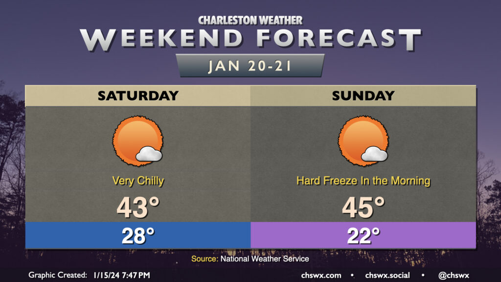
Another potent shot of Arctic air arrives overnight Friday into Saturday, and we’ll be feeling this one over the weekend. We start Saturday in the mid-to-upper 20s as very cold air characterized by temperatures in the single digits at 5,000 feet swings on through. Highs top out only in the low 40s — well below January normals. Sunday is even colder, with a hard freeze expected overnight Saturday into Sunday. This could be pipe-busting cold as lows drop to the low 20s in the metro area; it wouldn’t shock me to see some upper teens well inland, either. Temperatures will once again be limited to the mid-40s at best despite nearly full sunshine.
If there’s one bit of good news in this, it’s that it doesn’t look like the cold air will have too much staying power beyond Monday. Indeed, the extended temperature outlook suggests a period of warmer-than-normal temperatures will close out January. Stay tuned…
Follow my Charleston Weather updates on Mastodon, Bluesky, Instagram, Facebook, or directly in a feed reader. Do you like what you see here? Please consider supporting my independent, hype-averse weather journalism and become a supporter on Patreon for a broader look at all things #chswx!