Tuesday: More scattered storms amidst the sauna

Scattered showers and thunderstorms will stay in the forecast for much of the day Tuesday. While it won’t rain all day at any one location, a shower or storm will be possible pretty much anytime especially beyond 10am. Locally heavy rainfall will be possible, but severe weather is unlikely.
We start the day in the upper 70s to low 80s at the coast, warming to the low 90s in the afternoon. Dewpoints in the upper 70s yield heat indices in the mid-100s (though just shy of advisory criteria), which will continue this stretch of uncomfortably steamy weather.
Rest of the work week: Heat advisory likely Wednesday; staying unsettled
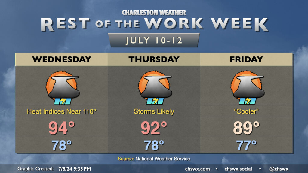
We’re staying on the warm and unsettled side for the rest of the week. Compressional heating ahead of a cold front (which will sadly stall and wash out over the Midlands) will help drive air temperatures up a few more degrees than they were on Tuesday (before storms initiate, anyway). The mid-90s highs combined with dewpoints in the mid-to-upper 70s will yield heat indices around 110°. Don’t be surprised to see a Heat Advisory on Wednesday as a result. Showers and thunderstorms will act to cool things off for at least a few of us, with generally scattered coverage expected.
As the front stalls out nearby, expect more in the way of showers and thunderstorms on Thursday and Friday as waves of low pressure develop, which in combination with the seabreeze will keep shower and storm chances elevated especially during the afternoon and evening. Locally heavy rain remains the main concern for any storms, though any rain will continue to help the abnormally dry conditions across the Lowcountry. Temperatures on Thursday return to the low 90s, while rain and cloud cover could keep highs suppressed to the upper 80s on Friday. Steamy starts to the day continue, though, with lows only bottoming out in the upper 70s away from the coast.
Follow my Charleston Weather updates on Mastodon, Bluesky, Instagram, Facebook, or directly in a feed reader. Do you like what you see here? Please consider supporting my independent, hype-averse weather journalism and become a supporter on Patreon for a broader look at all things #chswx!