The week ahead: Brief respite from the swamp comes to a close
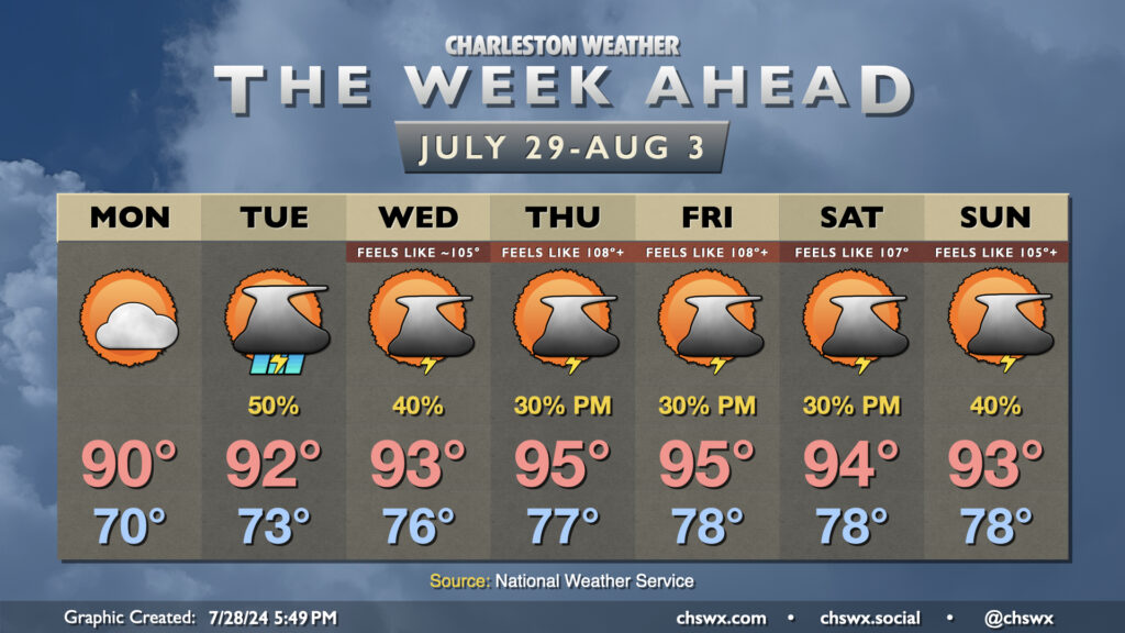
After a really nice Sunday that featured dewpoints dropping into the low 60s and no rain to speak of, we get one more day of lower humidity before we return to the swamp for the rest of the upcoming week. For Monday, though, enjoy lows around 70° yielding to highs around 90° in the afternoon with dewpoints generally in the mid-60s. We’ll see a mix of sun and clouds throughout the day, but rain should just hold off to our west for one more day. (Can’t rule out some showers near I-95, though.)
From there, the cooler and drier air gives way to a warm front, and showers and thunderstorms return to the forecast as a result. We could see decent coverage of storms Tuesday as the front lifts across the area and a disturbance moves by aloft. After that, though, expect generally the standard 20-30% afternoon thunderstorm chances heading into the rest of the week as high pressure ridges overhead.
As the pattern shifts back toward more typical summer weather, so it shall be with temperatures. In fact, we should head back above-normal as we close out July and enter August, with heat advisory conditions possible Thursday and Friday in particular. Low temperatures will once again head back into the upper 70s away from the coast, where lows may not dip below 80° at times later this week.
Tropics: Waking up a bit?
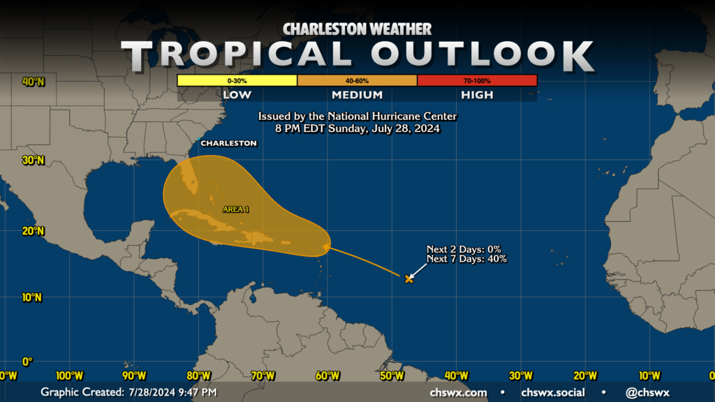
The tropics could be waking up just in time for August, when climatology says the season should start to get a little more active. Some model guidance, particularly the European ensemble, has been hinting at a wave developing into something a little more organized later this week as it treks westward across the Atlantic. Other guidance, such as the GFS, is having a tough time picking up on anything here right now. Wait and see, but for now, the National Hurricane Center gives this area a 40% chance to develop over the next week. There’s no substantial concern for the Lowcountry at this juncture, but nonetheless, we’ll keep an eye on it. It’s not a bad idea to brush up on your hurricane preparedness as we get into the peak months of the season; visit SCEMD’s hurricane guide for everything you need to know from disaster kits to evacuation zones.
Follow my Charleston Weather updates on Mastodon, Bluesky, Instagram, Facebook, or directly in a feed reader. Do you like what you see here? Please consider supporting my independent, hype-averse weather journalism and become a supporter on Patreon for a broader look at all things #chswx!