Friday & the weekend: Warm and unsettled as we watch the tropics
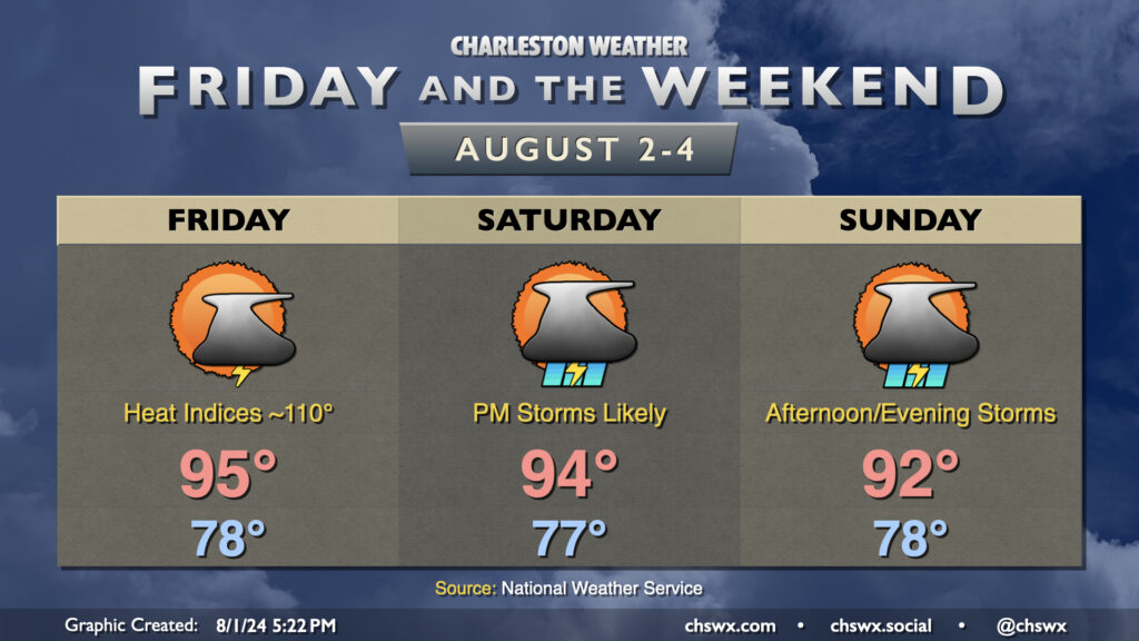
The weather stays hot and turns increasingly unsettled as we get into Friday and the weekend. Warmth peaks Friday; expect highs in the mid-90s to combine with dewpoints in the mid-to-upper 70s to yield heat indices approaching 110°. Another Heat Advisory, while having not yet been issued at publish time, certainly seems like a decent possibility for Friday, so keep that in mind if you have outdoor activities planned. Scattered showers and thunderstorms should provide some relief to a few of us, though slow-moving storms are certainly a possibility and could lead to some localized flooding. Strong wind gusts remain a concern as well.
Shower and storm chances increase heading into Saturday and especially on Sunday as a weakening front approaches the area and stalls out. Temperatures will start to trend downward a bit thanks to the increase in storm coverage and cloud cover, though Saturday continues to look quite toasty with peak heat indices around 105°. Storms should fire by mid-afternoon and could be somewhat numerous Saturday. Greater coverage is expected on Sunday as the front stalls nearby and moisture continues to increase. That’ll keep highs in the low 90s at most in the afternoon. While it won’t rain all day at any one location, slow-moving storms could produce localized flooding. Be ready to halt outdoor activities if a storm approaches.
Tropics: Development odds increasing on Atlantic wave now known as 97L
The National Hurricane Center has bumped up the odds a wave near Hispaniola, which got the designation Invest 97L this afternoon, will develop into a tropical cyclone. It now believes there’s a 70% (or high) chance the wave develops into a tropical cyclone over the weekend or early next week near Florida. Model guidance has signaled a shift westward over the past couple days, which tracks with a weaker system that’s currently dealing with a lot of land interaction over mountainous terrain. Guidance is generally consistent in having it pass very near, if not straight over, Cuba, then depositing it in the Gulf of Mexico. It’s here where development is most likely to take place, but from there, it’s anyone’s guess where it’s going to go. Model guidance diverges quite a bit in this timeframe, with some solutions keeping it moving west, other solutions recurving it north and then northeast across FL, and even others stalling it out near Florida (which could be particularly soggy).
As for us here at home, we’ll want to continue to watch the progress of this system given its location and expected development in the eastern Gulf. However, it remains too early to speculate on what, if any, impacts this disturbance could bring to the Lowcountry. Until a low pressure system takes shape, it will be tough for model guidance to lock on and provide a consistent forecast picture, so be very careful with model spaghetti plots and understand that they are subject to potentially significant change over the next few days. Your best bet is to continue to listen to local and NHC forecasters for decision-making information as they take that raw computer model information and synthesize it into the bigger forecast picture.
Follow my Charleston Weather updates on Mastodon, Bluesky, Instagram, Facebook, or directly in a feed reader. Do you like what you see here? Please consider supporting my independent, hype-averse weather journalism and become a supporter on Patreon for a broader look at all things #chswx!