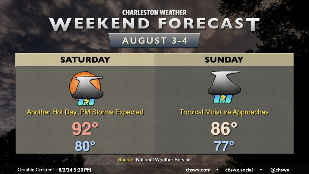
Weekend forecast: Hot ahead of tropical moisture arriving
So the disclaimer at the outset with this weekend’s forecast, especially for Sunday, is that a lot hinges on the eventual path, forward speed, and strength of what is, as of this writing, Potential Tropical Cyclone Four. You’ll want to keep closer tabs on forecast updates than you normally might as things are a little more fluid than normal due to the uncertainty.
With that in mind, though, one thing that’s certain is that Saturday is going to be a hot and muggy day with ample storms in the afternoon. Temperatures don’t look to get below 80° across more of the metro area than we might like, warming to the low 90s in the afternoon. Dewpoints in the upper 70s will yield heat indices that peak around advisory criteria (108°) before showers and storms develop and cool things down.
Sunday will start on the mild side once again, but showers and thunderstorms should — provided the current NHC track for Four holds — become fairly widespread across the area by Sunday afternoon as the surge of tropical moisture and a little daytime heating combine for some rather heavy downpours. The upside will be that highs will be suppressed to the mid-80s, but I’d expect it to be soggy enough to where we wouldn’t get to enjoy that all that much. An inch or two of rain will be possible Sunday, especially near the coast.
Potential Tropical Cyclone Four increasingly likely to bring heavy rain to the Lowcountry next week
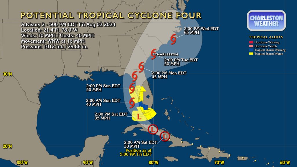
As we get into next week, we’ll continue to contend with PTC 4, which at that point will likely be Tropical Storm Debby. The 5PM forecast track has the center of future Debby moving slowly across Florida Sunday afternoon into the overnight, placing it into Georgia by Monday afternoon. From there, the center will trek slowly northward; the expectation is that high pressure will be, at a minimum, slowing down the escape route.
Heavy rain will continue to be possible Sunday night through at least Tuesday based on this current track. The early indication is for upwards of 6-8″ near the coast, with isolated amounts that could be even higher. However, without the storm having formed yet, the forecast remains quite uncertain as far as specific impacts, so check back frequently for updates. Still, it might be worth thinking about your flooding plan downtown as surge on top of heavy rain could start to become an issue as early as Sunday.
I can’t stress enough that this forecast remains especially uncertain. There will undoubtedly be changes as we go. The best advice is to respect this uncertainty by starting to think about what you’d do for power outages and flooding, especially near the coast. Changes could come with relatively little lead time this go-around, especially given that adverse weather should be occurring well away from the center of the storm, so the sooner you’ve got your battery stash and your generators tuned, the better.
Finally, I urge y’all to make sure that you are using the official National Hurricane Center forecast to make your decisions. Spaghetti models are just one part of the puzzle and won’t tell you the whole story of what to expect; they can even mislead at times. So, lean on the expertise at NHC — they’re the best at what they do — and you will be just fine.
Follow my Charleston Weather updates on Mastodon, Bluesky, Instagram, Facebook, or directly in a feed reader. Do you like what you see here? Please consider supporting my independent, hype-averse weather journalism and become a supporter on Patreon for a broader look at all things #chswx!