Tonight and tomorrow: Debby’s rains really start to kick in
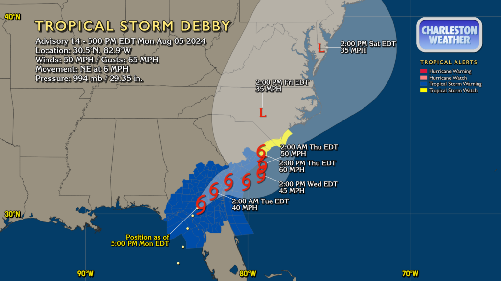
Debby made landfall this morning along the Big Bend of Florida as a Category 1 hurricane. It’s since fallen back to being a tropical storm with max winds now at 50 MPH, but its forward speed has been slowing as steering currents collapse around it. This is setting the stage for the well-advertised prolonged deluge and flash flood threat that will unfold particularly over the next couple days.
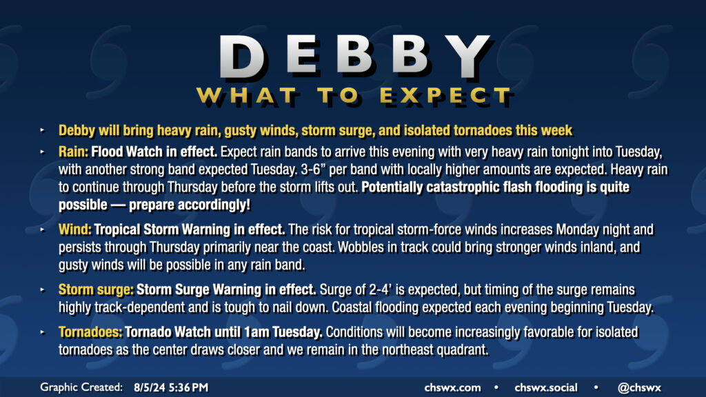
For our part so far, rain totals have been hit or miss. The downtown station at Waterfront Park got 0.95″ of rain as of 5PM, but the airport has received 2.88″ as of last count (5PM), which is a new record for August 5. We’ll very heavily eclipse that as we head into tonight as one of Debby’s main feeder bands moves through with very heavy rain and the risk for tornadoes. The threat for tornadoes lasts into the overnight, with a Tornado Watch in effect until 1AM. Make sure you have multiple ways to hear weather warnings, including a way that doesn’t require an Internet connection (such as a weather radio).
Rain will be significant overnight. Some spots will bag an easy 3-6″ overnight, with even greater totals possible. 10″ is not off the table! A Flood Advisory is in effect for the Charleston metro area through 9PM to account for this; we’ll need to see if this has to get upgraded later. You do not want to be out traveling once the rain kicks in, especially tonight, as roads could become very impassable very quickly. Much as if you’ll want to hear for tornado warnings, you’re going to need to listen for flash flood warnings as well. Stay home unless you absolutely must be out (essential employees, I completely understand). Don’t be the reason a first responder has to risk their life to come get you!
Tuesday-Thursday
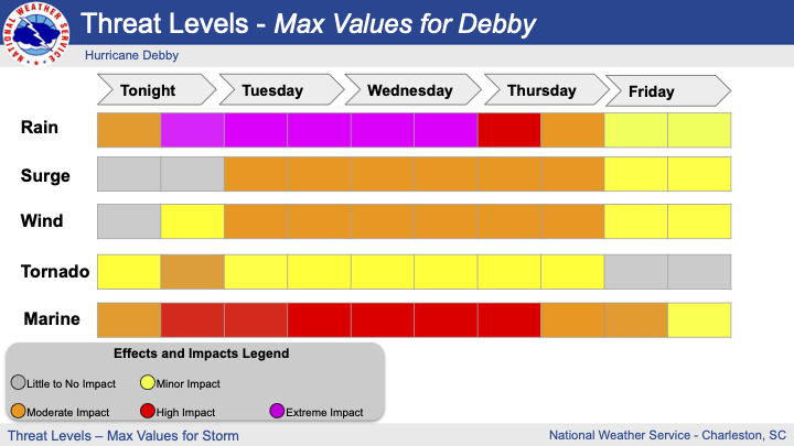
Debby’s effects peak during the mid-week period, with extreme rainfall a major consideration heading into Tuesday and Wednesday. A band of very intense rainfall appears possible to move across the Tri-County area during the day Tuesday. This will easily drive rainfall measurements north of 10″, and storm totals will begin to be measured in feet. This is also when tropical storm force winds will start to become a concern near the coast as the center meanders eastward over Georgia on its way back out into the Atlantic. The tornado threat could continue, but should diminish as the center works further out to sea and the shear profiles become less favorable.
Debby looks to remain over the water through Thursday afternoon ahead of a second landfall, which is currently expected somewhere between Awendaw and Myrtle Beach. Some strengthening is forecast, and Debby should be a mid-to-high-end tropical storm at its second landfall. All the while, rain will continue to spiral around the center and keep us in an off and on deluge until Thursday evening, when the center is forecast to be picked up by a trough and whisked away from here (finally).
What to do
At this point, it’s time to hunker down. Rain rates are going to head up and stay up especially Tuesday into Wednesday. Flooding will become quite a concern starting tonight. It’s such a concern, in fact, that the City of Charleston has imposed a curfew on the peninsula beginning at 11PM. It’s very possible that many businesses may choose to close over the next couple days; hopefully you’ve got what you need at this point to get by for a few days.
Be listening for flash flood and tornado warnings. Your phone will go off if you are in one of those polygons, but don’t just count on your phone — a battery-backed-up weather radio is a really smart play for situations like these. I’m particularly concerned about the risk for tornadoes overnight; tropical tornadoes spin up and down very quickly and are tough to warn for as is.
Finally, keep checking on the forecast. This is a marathon, not a sprint, and there’s still significant concerns around the uncertainty around the stalling system beyond Wednesday in particular. We’ll keep you posted. Hang in there…we’re in this together, and we’re going to be just fine.
Follow my Charleston Weather updates on Mastodon, Bluesky, Instagram, Facebook, or directly in a feed reader. Do you like what you see here? Please consider supporting my independent, hype-averse weather journalism and become a supporter on Patreon for a broader look at all things #chswx!