Friday & the weekend: Mostly quiet, not as sweltering
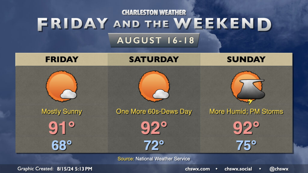
Friday and the weekend look mostly quiet as high pressure remains the main weather player for a few more days. We should start Friday in the mid-to-upper 60s in much of the metro (with low 70s on the coast); temperatures head to the low 90s in the afternoon under mostly sunny skies. With dewpoints in the mid-60s, the heat index could actually run slightly cooler than the air temperature (yes, this can happen!). So, while it’ll still be on the hot side, it won’t be quite as bad as it has been.
Winds go more southerly starting Saturday, and we’ll see a slow uptick in dewpoints as a result, but Saturday still looks quite good. We’ll start in the low 70s, warming to the low 90s in the afternoon under mostly sunny skies once again. Heat indices will run a degree or two warmer than the air temperature, but still generally not too out of bounds especially compared to what we’ve dealt with recently. Dewpoints creep back into the 70s on Sunday, and this will help drive a few scattered showers and storms in the afternoon and evening as another cold front approaches the area. We could see a stronger storm or two, but that’ll depend on the timing of the front. Overall, though, we should have a pretty good weekend of weather. And, given the fact that winds will go more southerly, the risk for coastal flooding is diminished for the upcoming weekend compared to yesterday’s forecast, though a little salt water on Fishburne at Hagood around the evening high tides could still be in play.
River flooding update
River Flood Warnings continue for the Santee near Jamestown and the Edisto near Givhans Ferry, while a Flood Advisory continues along the Ashley for spots around the Ashborough neighborhood and places immediately downstream as the river remains quite elevated.
Edisto River near Givhans Ferry
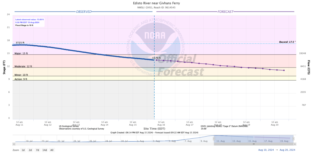
The Edisto continues to gradually fall as we head into the weekend off a peak of around 17.21′ a few days ago. It is now in moderate flood stage and is forecast to fall to minor flood early next week. Conditions should gradually improve as a result, and we should start to see roads become a little more passable in the Adams Run area next week.
Ashley River at Cooke Crossroads
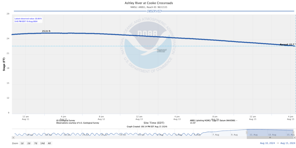
The Ashley River at Cooke Crossroads just this evening finally fell below its previous record stage of 22.7′ after a crest at 25.31′ this past Sunday. The river will gradually continue to fall, though flooding issues continue around Ashborough. While no forecasts are officially provided for this point, it does seem that we should finally see some improvement in this area as we get into next week as well.
Santee River near Jamestown
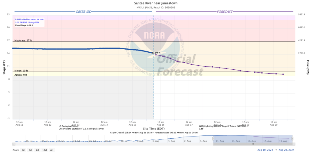
The Santee near Jamestown continues to fall as well, and should get below flood stage by early next week. It currently stands around 14.29′, which is a touch above where the forecast was expected. At this point, though, risk to residences has lowered, with impassable logging roads being the main impact here.
Swell from Ernesto reaches the area starting Friday
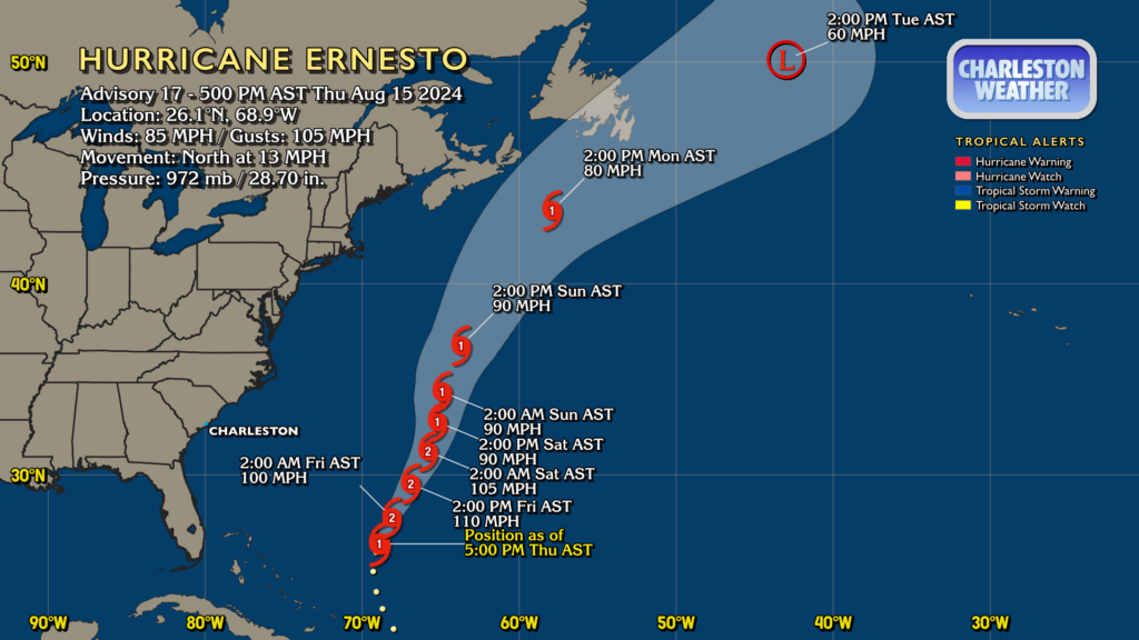
Swell from Hurricane Ernesto will reach our shores starting tomorrow and through the weekend, increasing the risk for rough surf and rip currents. This will be the extent of our impacts, though, as Ernesto looks to stay well off the coast. At 5PM, Ernesto had 85 MPH winds and was moving north at 13 MPH. It’s forecast to strengthen to a high-end Category 2 storm with winds peaking around 110 MPH tomorrow before gradually losing some punch as it approaches Bermuda, where Hurricane Warnings are in effect.
Elsewhere in the tropics, there’s nothing to write home about. We’ll take it in mid-August!
Follow my Charleston Weather updates on Mastodon, Bluesky, Instagram, Facebook, or directly in a feed reader. Do you like what you see here? Please consider supporting my independent, hype-averse weather journalism and become a supporter on Patreon for a broader look at all things #chswx!