Weekend forecast: Humidity creeps back in, storms increasingly likely late Sunday
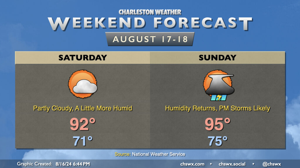
High pressure will gradually give way to another cold front this weekend, bringing humidity back to the picture particularly Sunday. However, the return to mid-70s dewpoints will be brief as slightly drier air moves back in behind the front next week.
Saturday will run a little warmer than Friday did. After another cool-ish (relatively speaking) start in the low 70s, temperatures warm to the low 90s in the afternoon as dewpoints creep back up to the upper 60s. This will make it feel more like 95° or so — not a huge jump, but certainly warmer than it’s felt the past couple days. Expect rain-free conditions on Saturday with one more day of high pressure in control before it cedes ground to the approaching front on Sunday.
Sunday starts warmer — back to the mid-70s — and warms to the mid-90s in the afternoon. Dewpoints in the low to mid-70s will yield heat indices around 100-102° at the height of the afternoon. As the seabreeze moves inland and the front draws closer, expect showers and thunderstorms to develop. Guidance doesn’t show much to write home about with the seabreeze activity — generally scattered coverage — but a round of thunderstorms ahead of the front looks like a good bet as we get into Sunday evening. Shear and instability will be favorable for a few severe thunderstorms, with damaging wind gusts the main concerns (though some hail can’t be ruled out, either). If we get greater coverage of seabreeze storms, that could lower the severe weather risk locally, but we’ll need to see how that materializes. Keep an eye on forecast updates for Sunday evening, just in case.
River flood updates
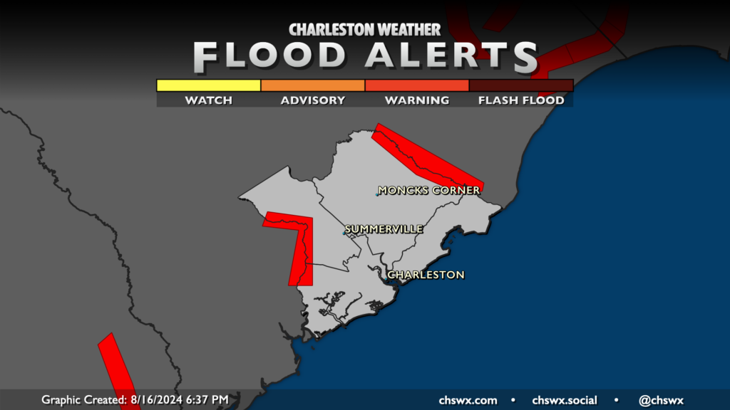
Improvement with river flooding should continue through the weekend as water levels continue to lower thanks to our stretch of rain-free weather over the past few days.
Edisto River near Givhans Ferry
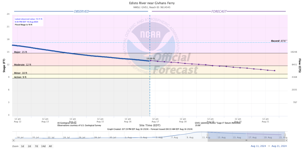
The Edisto River near Givhans Ferry continues to fall, with improvements starting to be realized in the flood zone. Expect some roads to reopen soon — perhaps this weekend — as the water level continues to fall through moderate flood stage to minor flood stage by Monday. Flooding looks to continue through at least mid-week, though by next weekend, it’s very possible we’re out of flood stage here.
Ashley River at Cooke Crossroads
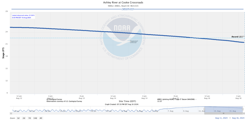
The Ashley River at Cooke Crossroads continues to steadily fall below the prior record of 22.7′ set during the October 2015 flooding event. Conditions are improving here as well, with officials reporting flood waters receding. This allowed the National Weather Service to cancel the long-running Flood Advisory that had been in effect here earlier this afternoon. Plenty of freshwater continues to drain, though, as the river has yet to return to its typical tidally-influenced fluctuations in water level.
Santee River near Jamestown
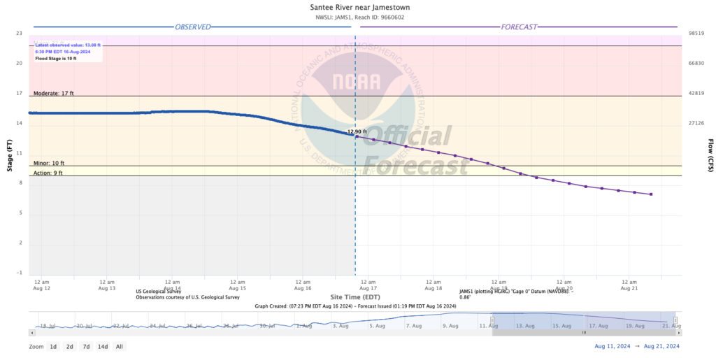
The Santee continues to fall at a good pace, with water levels falling below flood stage by Monday based on the current SERFC forecast. Any lingering issues here should resolve fairly quickly afterward, and we look to be in good shape on the Santee going forward.
Tropics: Ernesto approaches Bermuda
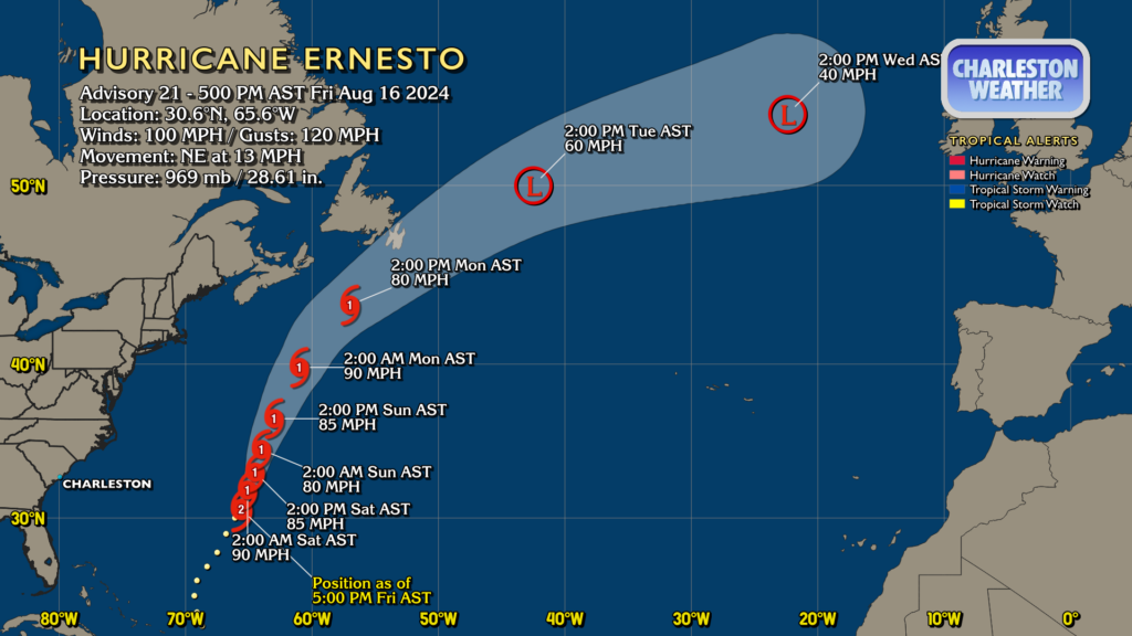
Hurricane Ernesto is lashing Bermuda with rain bands and gusty winds as it moves past Bermuda this evening. As of the 5PM advisory, it’s packing winds of 100 MPH and is moving NE at 13 MPH. Dry air has been disrupting Ernesto and will continue to do so, though Ernesto should maintain Category 1 intensity as it gains latitude through Monday before losing tropical characteristics by mid-week.
For our part in the Lowcountry, the rip current risk will remain high through at least Saturday. If you have beach plans to take some of the stress off the first week of school, it’s probably best to stay out of the water as those rips could be rather strong.
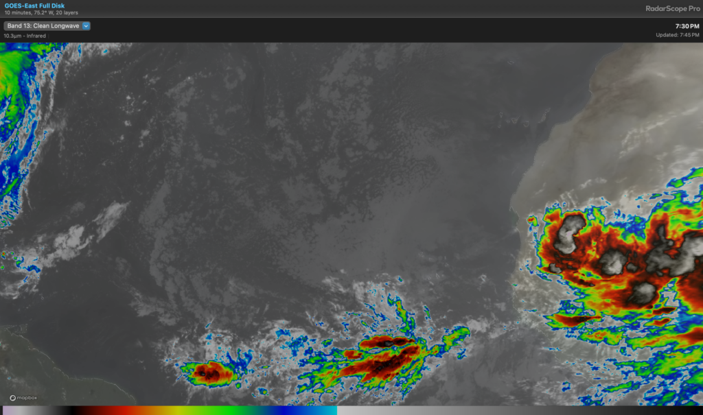
Elsewhere in the tropics, there are a couple waves of note at fairly low latitudes, as well as some strong convection over Africa that will be getting underway over the Atlantic this weekend. The National Hurricane Center hasn’t yet identified any areas for tropical development, but we are getting to the peak of the season — the vast majority of tropical cyclones that form in the Atlantic basin form between mid-August and mid-October. Stay tuned…
Follow my Charleston Weather updates on Mastodon, Bluesky, Instagram, Facebook, or directly in a feed reader. Do you like what you see here? Please consider supporting my independent, hype-averse weather journalism and become a supporter on Patreon for a broader look at all things #chswx!