The week ahead: Storms pause, heat returns
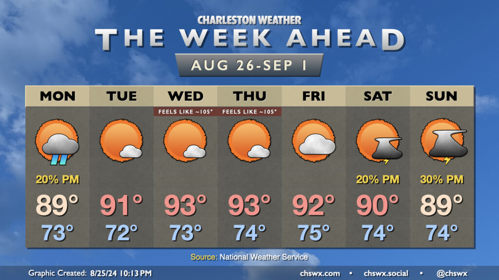
The final week of August will end on a warm and more humid note than the past 7-10 days have offered across the area. Storms will take a pause, though, as high pressure aloft puts a lid on widespread cloud cover, much less thunderstorm development, for much of the week.
The stationary front that’s kept shower chances in the neighborhood over the weekend still lingers nearby, and a shower or two will be possible (though unlikely) on Monday. Dewpoints will continue their steady climb, peaking in the mid-70s, which will make the upper 80s feel more like the mid-90s.
High pressure aloft will become more entrenched across the area starting Tuesday, setting us up for a rain-free stretch through Friday that will feature warmer-than-normal temperatures for late August. We should see highs peak in the low-to-mid-90s each afternoon, and with dewpoints peaking in the mid-70s, heat indices should head back into the 100s especially Wednesday-Friday. We’ll fall short of the Heat Advisory threshold of 108°, but it’ll still be plenty warm with just a few clouds to hide the sun from time to time. The high pressure pattern will keep winds generally light, too, so there won’t be much of a breeze, either.
As we head into Labor Day weekend, the high pressure ridge aloft gets shunted south and west as a trough digs in a bit to our north. This will kick up the chance for a few afternoon thunderstorms and take some of the bite out of the heat, but it’ll still be plenty warm as we bid farewell to summer as meteorological fall begins on Sunday.
Tropics: Still in a lull
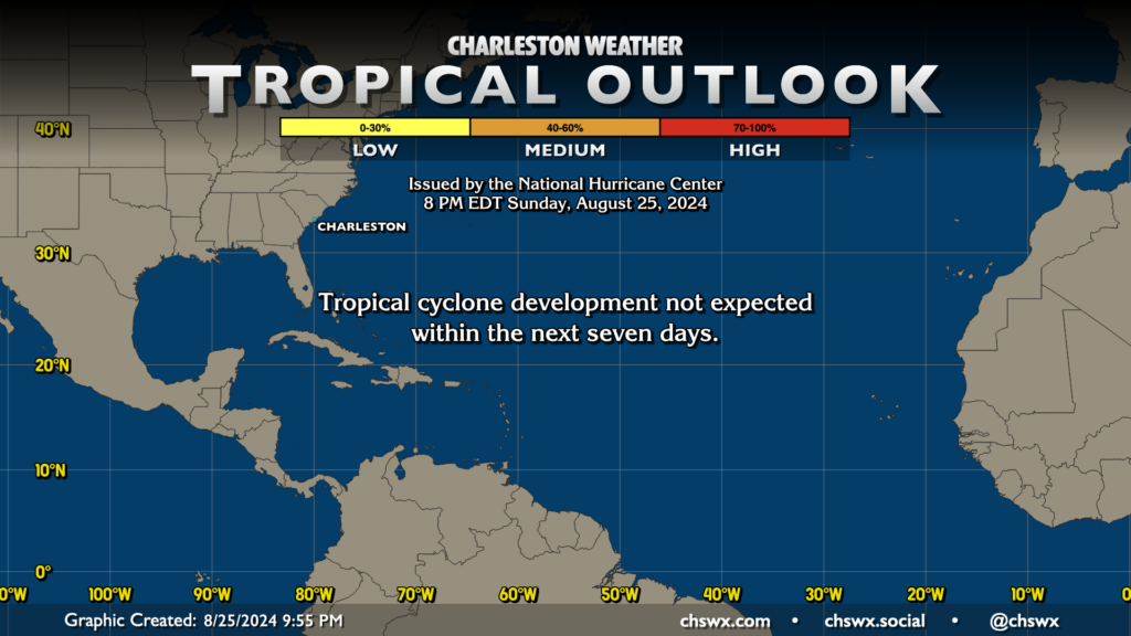
It’s not often that the Tropical Outlook during late August looks as quiet as it does, but here we are, with no tropical cyclone formation expected for the upcoming week. The global model ensembles don’t give us much to hang our hats on until possibly Saturday, when some of the ensemble members start to ping on low pressure potentially developing around 15°N and 45°W, but there is far from unanimous agreement for this. Still, it does seem that we could start to see things begin to wake up in the Atlantic starting Labor Day weekend and into the second week of September. The good news, though, is that there’s no current concerns for the Lowcountry. We’re barreling toward the climatological peak of the season on September 10, and while things have been relatively dormant since Debby and Ernesto, there’s still a lot of season left. Stay tuned, but enjoy the quiet times for now!
Follow my Charleston Weather updates on Mastodon, Bluesky, Instagram, Facebook, or directly in a feed reader. Do you like what you see here? Please consider supporting my independent, hype-averse weather journalism and become a supporter on Patreon for a broader look at all things #chswx!