The week ahead: Below-normal temperatures continue with a brief break in the rain
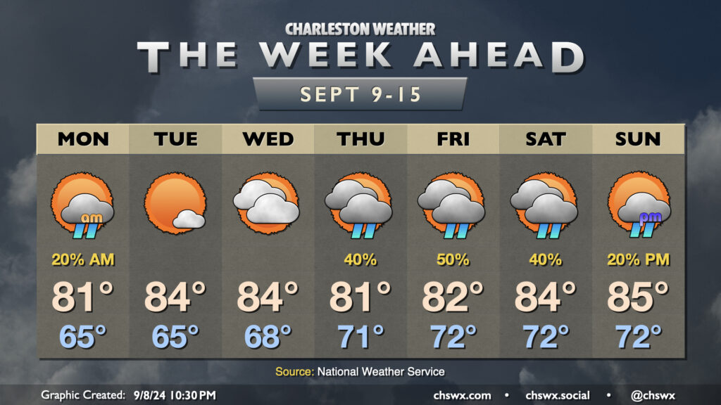
Below-normal temperatures will continue this week as we remain under in the influence of high pressure anchored to the northeast, with showers taking a break for a few days before returning to the forecast for the weekend.
A few lingering showers will be possible Monday morning with a stationary front nearby, though high pressure will continue to nudge that front further and further south, clearing us out for a couple nice days. Mostly cloudy skies keep highs capped to the low 80s on Monday after a mid-60s start, but we should see gradual reduction in cloud cover throughout the day. Tuesday looks to be rather nice, with lows in the mid-60s yielding to highs in the mid-80s under partly cloudy to mostly sunny skies. We’ll start to see the front to our south buckle a little more as low pressure — which is forecast to become Hurricane Francine — moves toward the Louisiana Gulf Coast during the middle of the week. This will net us an uptick in cloud cover and dewpoints for Wednesday, but we’ll get one more rain-free day in.
The high pressure center to our northeast that’ll give us a relatively quiet start to the week will be nudged eastward, which will allow the persistent stationary front to retreat a bit northward. This will bring an uptick in shower chances beginning Thursday and lasting into at least Saturday. It won’t rain all the time, but you’ll want to consider indoor plans as a backup to any outdoor plans. High temperatures will head down a bit with the uptick in cloud cover and showers, with highs in the low 80s expected Thursday and Friday before winds get a little more due-east, bringing some warmer temperatures back to the area for the weekend. Still, though, we stay below mid-September norms, generally running in the mid-80s Saturday and Sunday.
Tropics: Starting to look a little more like September
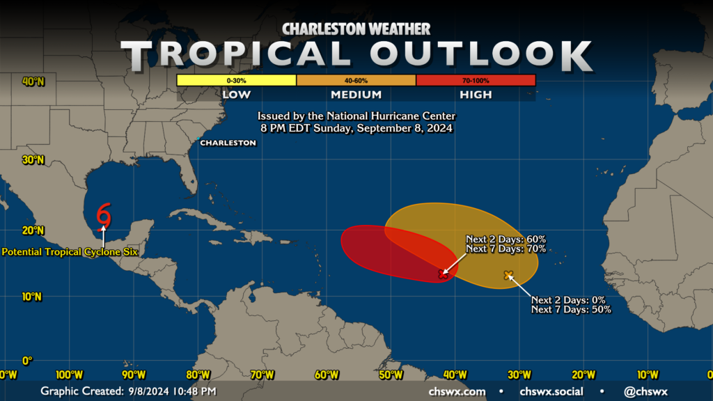
A very strange lull in Atlantic hurricane activity appears to be coming to an imminent end. Potential Tropical Cyclone Six was designated in the Bay of Campeche today; it’s expected to become Hurricane Francine and approach the east Texas and Louisiana Gulf coasts by mid-week. While it poses no direct threat to our weather locally, it will help dislodge (a little bit, anyway) the wedge pattern we’ve been in for the better part of a couple weeks and increase rain chances later in the week (as discussed above).
The National Hurricane Center is watching two other areas for development. The first, Invest 92L, is situated just to the west of 40ºW and is not moving too much. NHC does expect it to gradually develop and begin to move westward as the week goes on, with a 70% chance to develop within the next week. It’s very early in the game with 92L, so nothing to really worry about right now (and perhaps not at all).
The second area, situated around 30°W and 12°N, hasn’t yet really gotten going yet, but the Hurricane Center gives it a 50% chance to develop over the next seven days. It’s way out there, and once again is nothing to really worry about at this point (and, once again, may never be a cause for concern locally at all).
The climatological peak of hurricane season is September 10. Still plenty of time for more mischief, though the dire seasonal outlooks appear to be falling short. We’ll take whatever reprieve we can get, wherever we can get it!
Follow my Charleston Weather updates on Mastodon, Bluesky, Instagram, Facebook, or directly in a feed reader. Do you like what you see here? Please consider supporting my independent, hype-averse weather journalism and become a supporter on Patreon for a broader look at all things #chswx!