Rest of the work week: Clouds & showers return
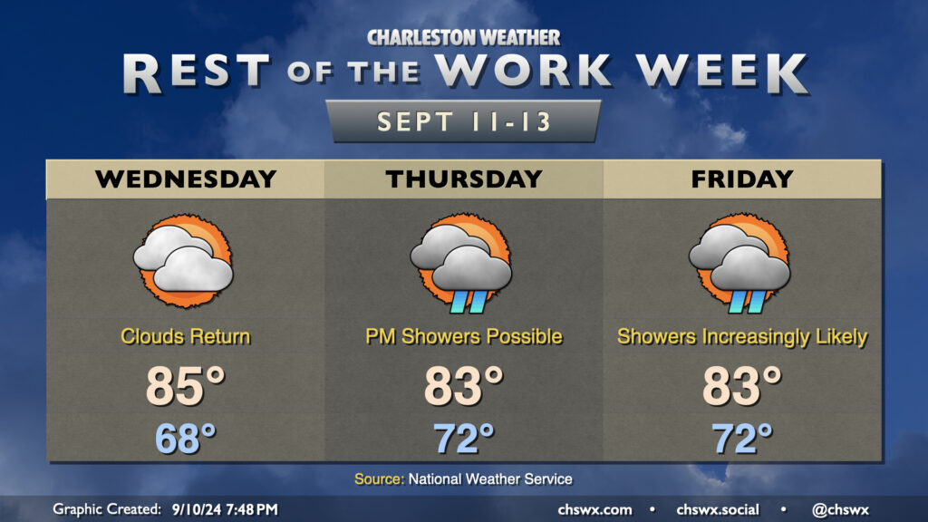
After a beautiful Tuesday featuring plenty of sun and comfortably warm temperatures, cloud cover returns to the area as moisture from Hurricane Francine lifts northward across the area. While Francine won’t have direct impacts in the Lowcountry, its northward advance into the Mississippi River valley will shove high pressure offshore, allowing the stationary front that has been draped to our south to start to retreat northward a bit. Upglide across the frontal surface and high pressure will help produce showers and maybe a few thunderstorms as well.
Wednesday looks to be rain-free with merely an uptick in cloud cover and dewpoints. We’ll start the day much warmer than we started Tuesday, with lows generally in the upper 60s to around 70°. Temperatures warm to the mid-80s in the afternoon despite the increasing cloud cover.
Much of the metro should get Thursday in rain-free as dry high pressure continues to hang tough at the surface, but we’ll start to see that erode with time, introducing some shower chances to the forecast starting Thursday afternoon. Cloud cover and persistent northeasterly winds will cap highs to the low to mid-80s after starting in the low 70s. Moisture more fully overtakes the area by Friday, and this leads to increasingly numerous showers and maybe some thunderstorms across the area as we get through the day, with rain chances peaking in the afternoon and evening hours. Once again, highs will be limited to the low to mid-80s with the cloud cover and expected rain.
Coastal flooding risk increasing starting Thursday
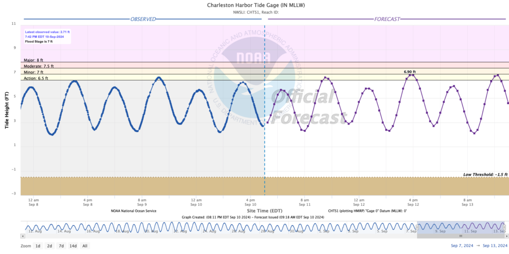
We’ll want to keep an eye on water levels in Charleston Harbor as we head into late week and the weekend as we approach a full moon at perigee and northeasterly winds continue to persist across the area. The official total water level forecast currently keeps water levels just below flood stage with the afternoon high tides Thursday and Friday, but it’s not out of the question that we could see this forecast revised upwards. And while flooding rains are not a significant concern heading into late week, any heavy rain over downtown near one of these tides will have a tough time draining out. We’ll keep an eye on it, but it’s something to file away.
Follow my Charleston Weather updates on Mastodon, Bluesky, Instagram, Facebook, or directly in a feed reader. Do you like what you see here? Please consider supporting my independent, hype-averse weather journalism and become a supporter on Patreon for a broader look at all things #chswx!