The week ahead: Turning warmer, but first, a little tropical mischief
The area of disturbed weather along the lingering stationary front we’ve been watching for a few days off the coast has been tagged as Potential Tropical Cyclone Eight this evening, prompting a Tropical Storm Warning from Edisto Beach to Ocracoke Inlet, NC, including the Charleston metro area. It brings with it some breezy rain and an increased coastal flood risk for Monday, but is not expected to be a high-end event for the Lowcountry. Its stay will be brief, with warming and generally quiet weather in the offing for the rest of the week.
Potential Tropical Cyclone Eight expected to become Helene before landfall in SC
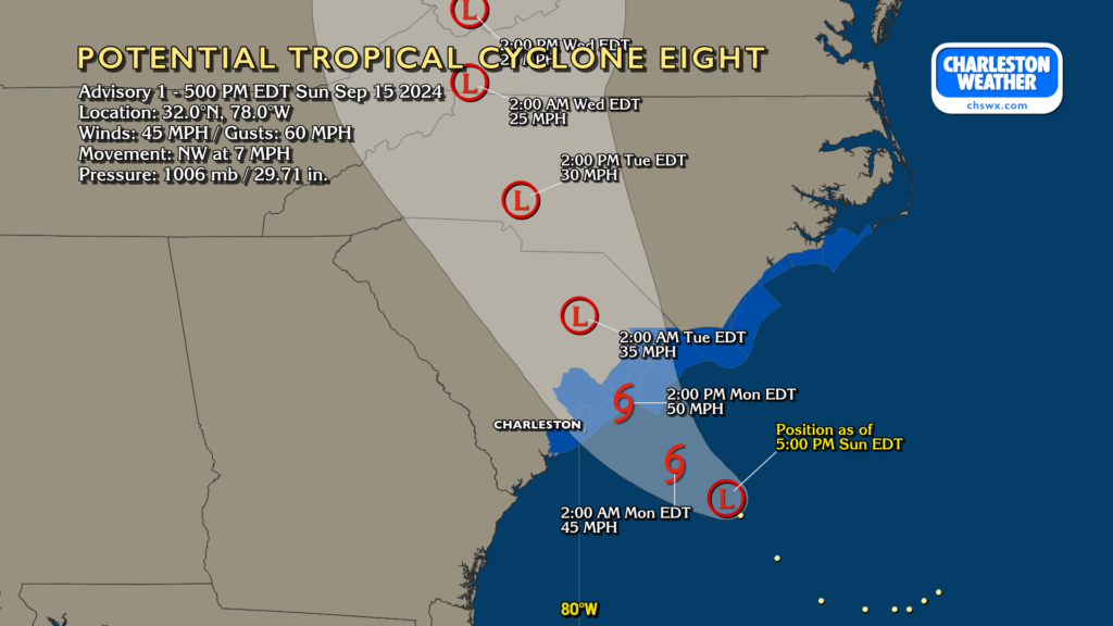
At 5PM, Potential Tropical Cyclone Eight had maximum winds of 45 MPH and was moving northwest at 7 MPH. It’s not yet formed a coherent low-level center, so it is not yet named. If that happens (and it is forecasted to), it will be named Helene. The forecast track — which is rather uncertain especially since the storm hasn’t yet quite formed yet — brings the center of Eight northwestward to a landfall around the Santee by mid-afternoon Monday.
As I alluded to above, all indications are that this isn’t going to be a high-end event for the Charleston metro. If anything, it’s just a continuation of what we’ve been experiencing over the past couple days; periods of rain, sometimes moderate to heavy, with wind gusts approaching 20-30 MPH at times. Gustier conditions are expected closer to the coast, and this is why the tropical storm warning has been extended southward, with gusts to 40 MPH possible at the beaches. Additionally, a more southward track could bring some of the heavier rain associated with Eight into the metro. However, significant storm surge is not expected (though coastal flooding due to the full moon is forecast; more on that shortly), and there will be no tornado risk with Charleston coming in on the southwest side of the circulation.
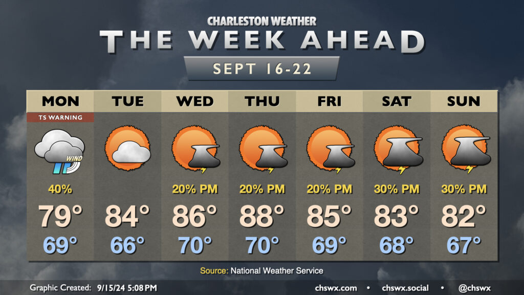
What to expect on Monday
Monday’s expectations would largely be the same regardless of whether a named storm was approaching or not. Count on some gusty showers at times, with pockets of heavy rain possible. Storm totals should generally top out around an inch at most in the vast majority of the area, though some heavier amounts are possible in upper Charleston and Berkeley counties. And, again, the risk for heavier rain trends southward if the storm comes in further south than currently forecast. Gusts 20-30 MPH are the current expectation for the metro area, with gusts 40+ MPH expected at the beaches and over the coastal waters. A few power outages aren’t totally out of the question, but the vast majority of us should be fine.
Coastal flooding threat persists around times of high tide
Even though there is no explicitly-forecast storm surge concern for the Lowcountry, the threat for coastal flooding will continue courtesy of the impending perigee of the full moon and the persistent northeasterly winds. Minor flooding will be possible with the 6:46 AM high tide Monday morning, with moderate flooding possible with the evening high tide peaking around 7:23 PM. The evening high tide in particular should be high enough to close some roads, so you’ll want to factor this into your downtown plans.
Southward shifts of the track could have impacts on this coastal flooding forecast, so be sure to stay tuned for updates.
Rest of the week: Back to warm for a few days
Presuming all goes to plan, after Eight comes ashore Monday afternoon and continues moving northwestward away from the area, we’ll see generally quiet weather starting Tuesday and beyond. Temperatures will be on a warming trend as high pressure ridges in aloft, with upper 80s possible by mid-week. A stray shower or storm will be possible each afternoon, but overall, it doesn’t look too shabby at all. Surface high pressure could wedge back in for the weekend, sending temperatures back below normal for the weekend with shower chances continuing.
Follow my Charleston Weather updates on Mastodon, Bluesky, Instagram, Facebook, or directly in a feed reader. Do you like what you see here? Please consider supporting my independent, hype-averse weather journalism and become a supporter on Patreon for a broader look at all things #chswx!