Rest of the work week: Eyes on Helene
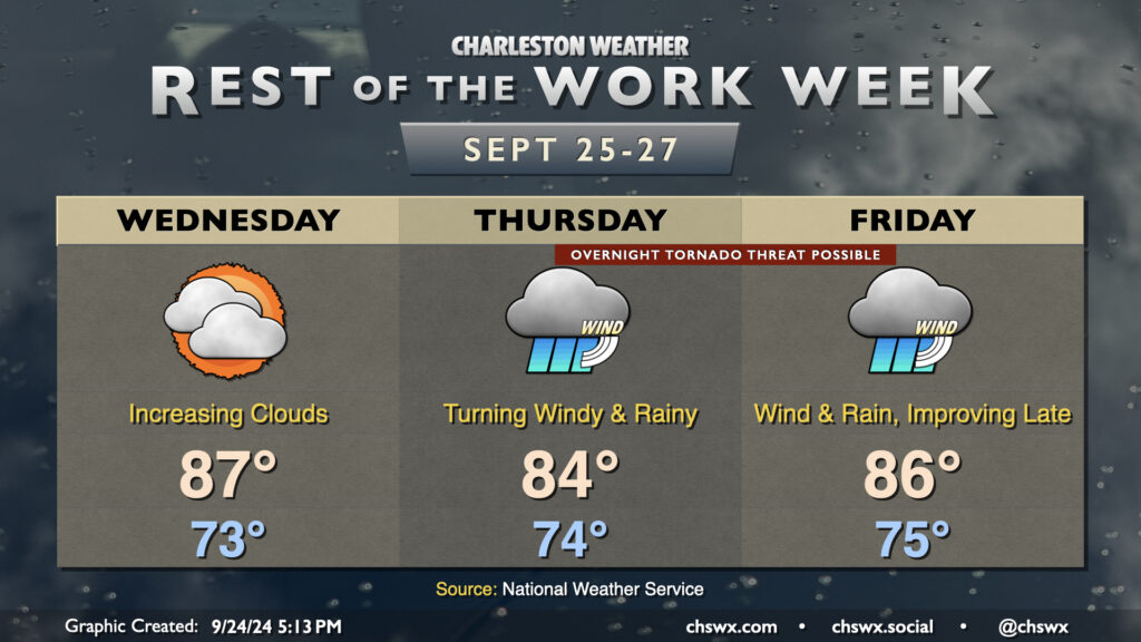
The rest of the work week will make you not want to hear the name “Helene” for a little while after it’s all over. We have one more day before wind and rain associated with the tropical storm arrive in the Lowcountry on Wednesday; it’ll be a warm and muggy day, but your last best opportunity to bring some loose things inside just to be safe. Temperatures start in the low-to-mid-70s, warming to the mid-to-upper 80s in the afternoon despite the increasing cloud cover. A few showers can’t be ruled out very late in the day, but the better chances for rain begin on Thursday.
On the current track, Helene will make landfall Thursday night in the Big Bend area of Florida as a major hurricane. It’ll be moving at a pretty decent forward speed, which should spread increasing showers and maybe thunderstorms into the area throughout the day Thursday. Helene’s impacts look to peak Thursday night into Friday morning, with gusty winds, heavy rain bands, and possibly a few tornadoes. Yes, we’ll need y’all to have your weather alerting devices in the on and alarming position Thursday night in case a tornado warning is issued. Some coastal flooding is also possible especially around high tide as onshore winds push some storm surge into the area, though the surge threat does not appear serious at this point.
Heavy rain and the tornado threat continue into Friday morning. Helene will be making quick work to the north and northwest, though, and we should see rain and wind gradually die down as the day goes on. Winds will start to take more of a westerly tack as Helene’s circulation moves away, and that should help blunt additional coastal flooding concerns on Friday. And by the weekend, we’re Helene-free.
Latest data and track for Helene
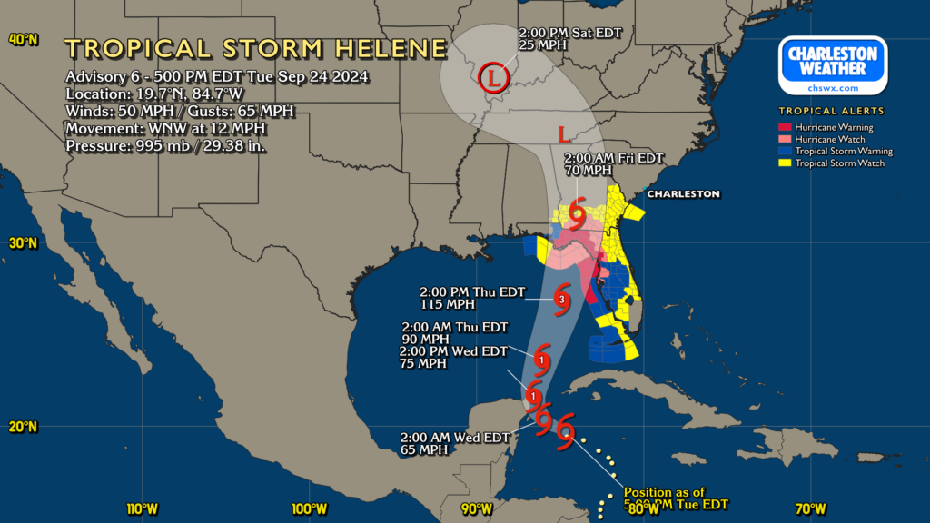
At 5PM, Helene was a Tropical Storm in the northwest Caribbean with maximum sustained winds of 50 MPH moving WNW at 12 MPH. It should make more of a northerly turn as it begins to interact with an upper low as we get into tomorrow, followed by a small bend to the northeast as it approaches landfall on Thursday night as a major hurricane on the Big Bend of Florida. Helene then turns more northward and then northwestward again as it pushes toward Atlanta on Friday.
Tropical Storm Watches are not out yet for South Carolina, though that may change as we head into the evening and Wednesday. Stay tuned to forecast updates as more fine-tuning occurs.
Follow my Charleston Weather updates on Mastodon, Bluesky, Instagram, Facebook, or directly in a feed reader. Do you like what you see here? Please consider supporting my independent, hype-averse weather journalism and become a supporter on Patreon for a broader look at all things #chswx!