The week ahead: Warm start, but a cooling trend ensues
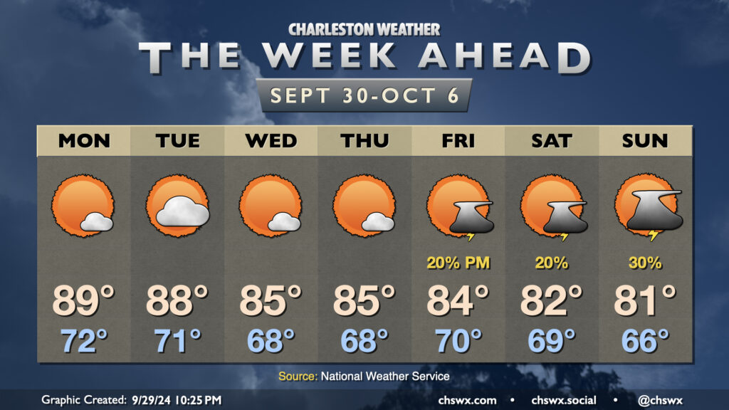
There’s not too terribly much to write home about in this week’s forecast so far, which is a fine departure from this point last week when we were looking at the genesis of what would become Hurricane Helene. We close September on a warm note, but a cooling trend begins to kick in by mid-week, with a few showers and thunderstorms — and much cooler conditions — possible by the weekend.
Warmer-than-normal temperatures will continue for a couple more days as Atlantic high pressure remains in control, with generally partly cloudy to mostly sunny skies and very low rain chances. Low 70s on Monday yield to the upper 80s, and we do the same on Tuesday. From there, a dry front moves by for Wednesday, and this knocks the edge off the heat a little bit as we start Wednesday and Thursday in the upper 60s with highs in the mid-80s each afternoon. There’s a little more in the way of cloud cover, but we should still stay rain-free.
Another front moves by Friday with high pressure wedging southward. A stray shower or storm appears possible with lows around 70° and highs in the mid-80s. For the weekend, we find the potential for a little moisture to run atop the wedge, keeping low chances of showers and thunderstorms in play each day (but no washout, either). Temperatures on Saturday start in the upper 60s but only peak in the low 80s, and Sunday starts out a little cooler with mid-60s on the way to the low 80s once again in the afternoon. Northeasterly winds will cause tide departures to kick up some, but right now, there appear to be no coastal flooding concerns with water levels staying in Charleston Harbor’s action stage of 6.5-7.0′.
Tropics remain quite busy
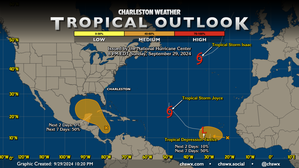
The tropical map is quite busy as we head into the last day of September, with two named storms on the decline in Issac and Joyce, while Tropical Depression Twelve joined the “party” this evening. These three classified tropical cyclones pose no risk to the US, much less the Lowcountry.
There are two areas of interest for development in the next week. A tropical wave that’s just emerged from the coast of Africa has a 50% chance to develop in the next seven days, but it’s a long way off and the general pattern seems to favor recurvature as we are seeing with Joyce and TD Twelve.
The second area of interest is in a familiar place in the western Caribbean. The ensemble of the global model guidance generally points to this area probably generating a tropical cyclone in the next week or week and a half; for its part, NHC gives it a 50% chance in the next seven days. This certainly isn’t the best or most welcome news on the heels of Helene, but right now there’s no evidence to suggest that there is a comparable threat at this point. For its part, the Weather Prediction Center has low pressure moving eastward across the Florida peninsula over the weekend, which helps send some moisture our way, but the low pressure system appears fairly weak. We’ll keep an eye on it, of course, but right now there’s nothing for us to be terribly concerned about. If that changes, I’ll let you know.
Follow my Charleston Weather updates on Mastodon, Bluesky, Instagram, Facebook, or directly in a feed reader. Do you like what you see here? Please consider supporting my independent, hype-averse weather journalism and become a supporter on Patreon for a broader look at all things #chswx!