The week ahead: Coolest weather thus far this season for mid-week

We’re back on the temperature rollercoaster this week as a front moves by on Tuesday, which will usher in the coolest airmass thus far this season for mid-week. (Certainly a far cry from watching another tropical system, that’s for sure.)
First, though, we have one more day in the 80s before the front gets through. It’ll be the warmest day of the week, starting around 60° and warming to the mid-80s in the afternoon. We’ll get within spitting distance of the record high of 88° set in 1943 and 1990, but we should stay below that mark. Much like Sunday, expect another day of unfettered sunshine on Monday.
The front moves by Tuesday with a little more in the way of cloud cover but little else. That will cool highs off to the mid-70s, roughly 10° or so cooler than Monday. We really feel the cooler airmass on Wednesday, though, as temperatures fall to the upper 40s in the morning, only reaching the mid-60s in the afternoon. Thursday runs even cooler in the morning, with mid-40s reaching back to the mid-60s once again. No rain’s expected with this frontal passage, and we’ll see primarily sunshine more than anything else.
After one more start in the mid-40s, a warming trend commences Friday as highs climb back to the low 70s. Saturday will run a little warmer, with highs in the mid-70s, and we’ll run even a click warmer on Sunday as well, with plenty of sunshine throughout.
Coastal flooding possible later this week
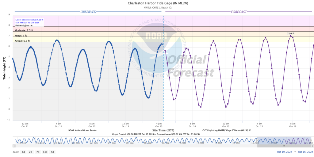
As the moon turns full later this week, the risk for coastal flooding will increase around times of high tide. We could get close on Tuesday evening, though Wednesday morning’s high tide should start a cycle of breaching minor flood stage in the harbor around those high tides. Be ready for coastal flooding to factor in at times; listen for Coastal Flood Advisories from the National Weather Service to keep you up to date on the best chance for road closures.
Tropics: One area out in the Atlantic, but mostly quiet (finally)
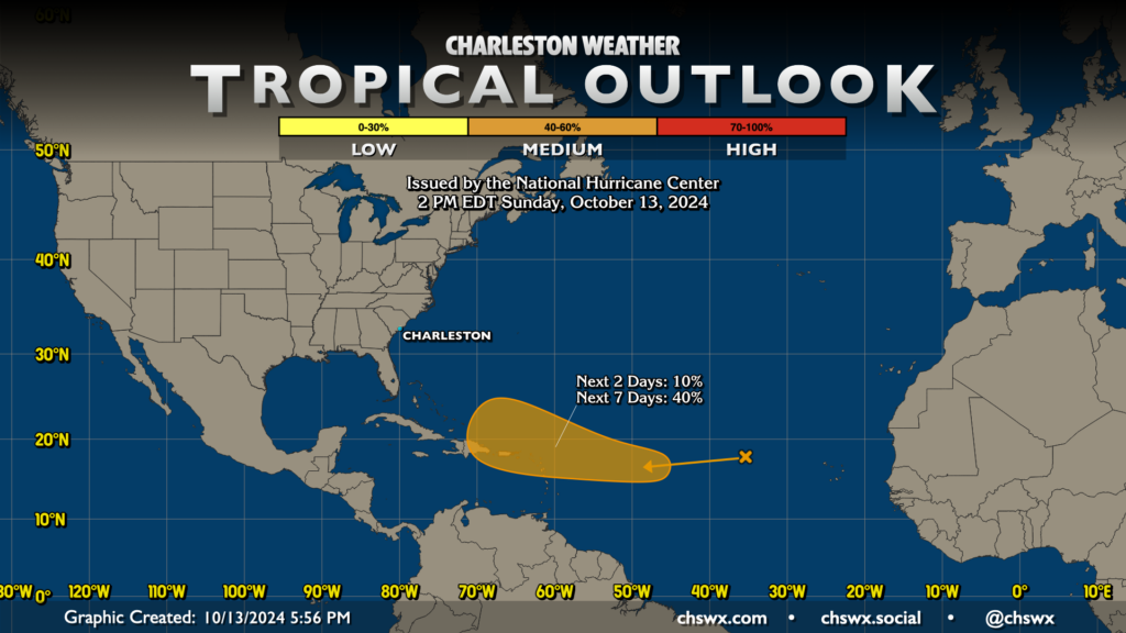
You’d have to go back to early September to find a tropical outlook without an active named storm on the map. The respite is welcomed, but we’ll be keeping an eye on an area of disturbed weather which has a 40% chance to become a tropical cyclone later this week into the weekend as it approaches the Lesser Antilles. It’s a long way out and far from an immediate concern, but I’ll watch it all the same.
Follow my Charleston Weather updates on Mastodon, Bluesky, Instagram, Facebook, or directly in a feed reader. Do you like what you see here? Please consider supporting my independent, hype-averse weather journalism and become a supporter on Patreon for a broader look at all things #chswx!