Rest of the work week: Sweater weather warning as temperatures plunge
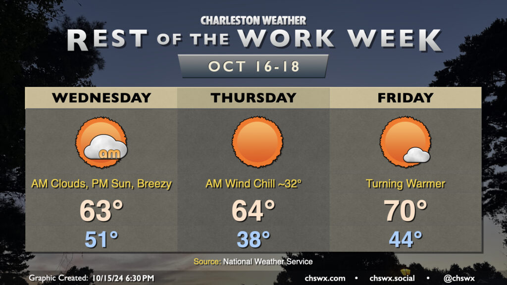
A reinforcing cold front will swing through overnight tonight, ushering in the coldest air so far this season. We’ll start the day in the low 50s, but gusty north winds will cause temperatures to struggle to the low 60s despite increasing sunshine as clouds from the frontal passage dissipate. This certainly qualifies for sweater weather in our neck of the woods — have the warm clothes at the ready!
Thursday morning will be the coldest of the set as the cool air continues to push into the area, though winds will diminish a little. Temperatures in much of the metro could dip into the upper 30s to around 40° — quite possibly the coldest morning since February 22, when it was 37°. The wind chill will be a factor (pun somewhat intended), and could make it feel close to freezing. A couple layers aren’t the worst idea heading out the door in the morning. Despite full sunshine, temperatures will still only recover to the mid-60s at best in the afternoon. This is well below normal for this point in the year (think upper 70s), and may flirt with record cold high temperatures as well (62° set in 1970).
Temperatures start to bend back toward climatology on Friday, though. We’ll start the day in the mid-40s as a bit more of an onshore component to the wind develops, heading to about 70° in the afternoon under sunny skies once again. As we get into the weekend, temperatures will continue to run a bit below normal, but mid-70s will mean short sleeves are back on the menu. With plenty of sunshine, it’ll be a solid weekend of San Diego-like weather (if you know, you know).
Coastal flooding concerns increase for the second half of the week
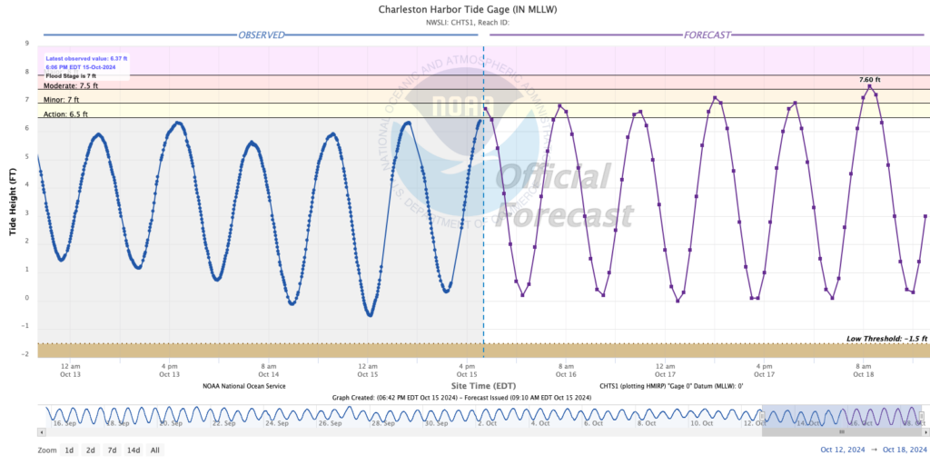
The latest total water forecast for Charleston Harbor has been revised down a click for Wednesday and Thursday as wind directions look to be more northerly than northeasterly. This should keep notable coastal flooding issues at bay on Wednesday, though the water level in the harbor may still be high enough in the morning to put some salt water on Fishburne and Hagood. Coastal flood issues should begin in earnest with Thursday morning’s high tide, as water levels look to peak around 7.2′ in the harbor as the moon gets fuller and draws a little closer (perigee). From there, we should see minor coastal flooding again with Thursday evening’s high tide. Right now the main concern looks to be Friday morning’s high tide, which will peak in moderate flood stage. This may close some roads downtown, and it would happen during the commute. We’ll keep an eye on this to see how the water level forecast evolves — stay tuned.
Tropics: Still a couple spots to watch, but nothing to worry about
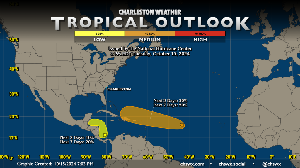
It’s admittedly difficult to talk tropics in the same post as we’re talking about wind chills in the 30s, but so it goes. No major changes with the outlook today from yesterday; NHC still has a medium chance for Invest 94L, located roughly around 44°W and 16°N, to develop into a tropical cyclone over the next week as it moves westward. The pattern continues to favor either the recurvature of a stronger storm or a weaker storm continuing to move west, bypassing the continental US, so right now, I’m still not terribly concerned about this area. Given the location, I’ll keep an eye on it, but again, no worries at this point. Nor am I concerned about the area that’s hugging Central America, which has a low chance to develop in the next few days before plowing back onto land.
Hurricane season does roll on for another month and a half, so we still need to keep one eye open on the tropics. However, the sigh of relief gets closer every day. Hang in there.
Follow my Charleston Weather updates on Mastodon, Bluesky, Instagram, Facebook, or directly in a feed reader. Do you like what you see here? Please consider supporting my independent, hype-averse weather journalism and become a supporter on Patreon for a broader look at all things #chswx!