Thursday: Fall chill continues
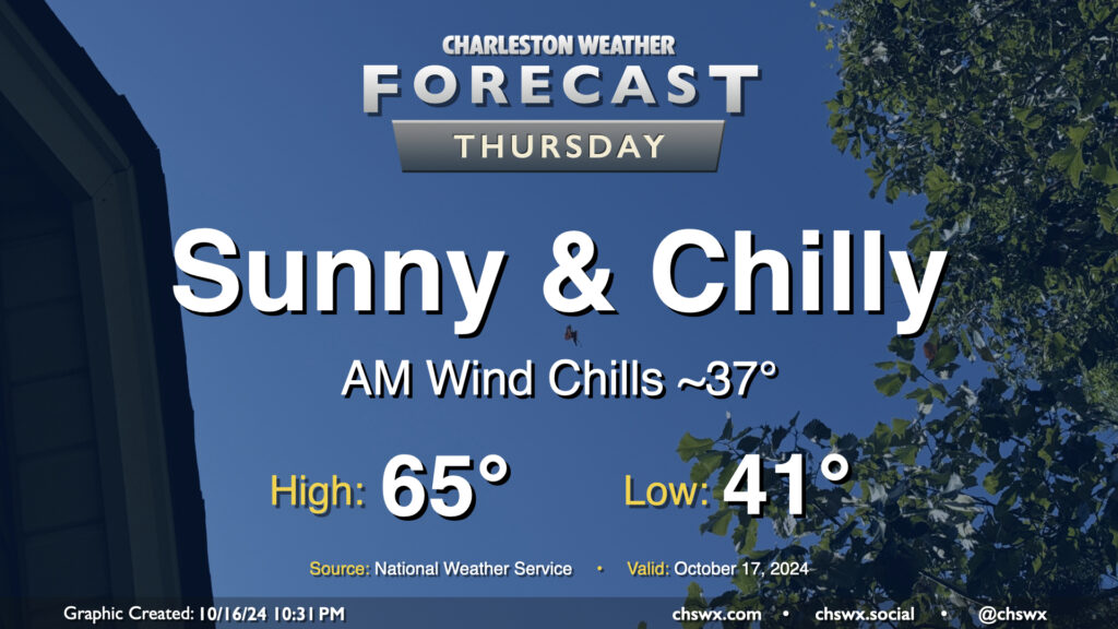
Temperatures reminiscent of November rather than mid-October continue on Thursday despite unfettered sunshine. We’ll start the day in the low 40s in the metro, with some upper 30s possible further inland. The wind chill will feel closer to the mid-to-upper 30s, so once again, layers are a good idea tomorrow morning. Temperatures head to the mid-60s in the afternoon, so keeping some sort of long sleeves around for when you’re not in sunlight is a smart play. Northerly winds will once again be breezy, generally 10-15 MPH in the afternoon with higher gusts.
We’ll also need to watch for minor coastal flooding during the Thursday morning commute. Water levels are expected to peak around 7.1-7.3′ with the 8:13 AM high tide. The more northerly component of wind will minimize coastal flood impacts a little, but we can still expect a few road closures in the more vulnerable locations of downtown Charleston. Be ready to reroute.
Friday & the weekend: A slow warming trend as coastal flood impacts peak
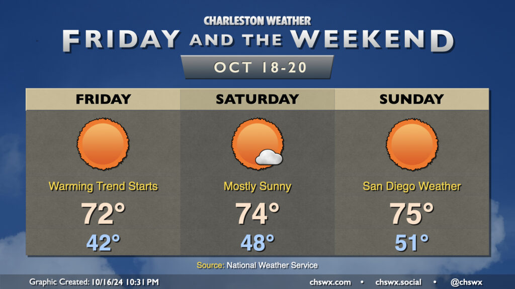
We’ll start to see the airmass moderate a little more starting Friday as ridging begins to build in aloft. This will help temperatures gradually warm over the weekend, though we will stay generally below normal for this point in October. Friday gets off to another chilly start in the low 40s (with wind chills once again dipping into the 30s), but we’ll run about 5-7° warmer Friday afternoon than we will on Thursday. Warmer starts follow for Saturday and Sunday, while highs generally top out in the mid-70s each afternoon with copious amounts of sunshine. Indeed, we’ll get a whiff of that San Diego feel to the weather especially as we get into the weekend.
The only issue will continue to be coastal flooding as the full moon reaches perigee and winds take a more favorable turn to the northeast. This will drive water levels into moderate flood stage for at least Friday and Saturday morning’s high tides, which could close additional roads downtown as well as on Long Point Road in Mt. Pleasant. Given persistent northeasterly flow, it certainly seems that we should see minor to moderate flooding Sunday morning, too. Stay alert for Coastal Flood Advisories from the National Weather Service. And otherwise, enjoy the nice weather!
Follow my Charleston Weather updates on Mastodon, Bluesky, Instagram, Facebook, or directly in a feed reader. Do you like what you see here? Please consider supporting my independent, hype-averse weather journalism and become a supporter on Patreon for a broader look at all things #chswx!