Rest of the work week: Much more seasonable with another shower chance Thursday

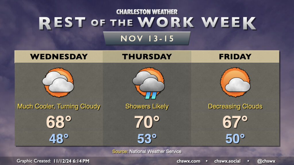
Cooler and drier air will push in overnight as high pressure wedges into the area from the north. This will make for a much cooler day on Wednesday than we’ve had in quite some time, with lows in the upper 40s in many spots away from the coast expected in the morning. High temperatures should only peak in the upper 60s as cooler air moves in. Increasing cloud cover as the day will also assist in keeping temperatures a little lower, too.
High pressure will break down Thursday as a cold front approaches, driving up the risk for showers particularly from midday into early evening. We’ll start the day in the low 50s, warming to around 70° in the afternoon. Rain should generally be on the light side, though some pockets of heavier rain can’t be totally ruled out, either.
The front clears the area for Friday, and cloud cover scours out during the day as a result. Temperatures, though, will once again struggle to the mid-to-upper 60s as cool air behind the front continues to push in. This sets the stage for a seasonably nice weekend, though, with lots of sunshine expected. Expect highs in the upper 60s Saturday, with low 70s returning for Sunday, right around where we should be at the midpoint of November.
Coastal flooding concerns increase starting Wednesday morning

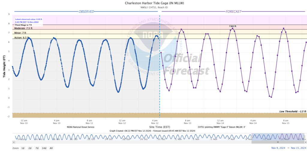
With the impending full moon at perigee along with favorable northeasterly winds, coastal flooding will once again return to the picture starting with the Wednesday morning’s high tide, which will peak around 5:08am right around the moderate flood threshold of 7.5′. This could cause some commute trouble for early risers headed downtown, so be ready to reroute in case you encounter a flooded road. Minor flooding will be possible with Wednesday evening’s high tide around 5:30 PM; while major issues aren’t anticipated, some salt water could still cause issues around the Citadel (namely Fishburne at Hagood), so keep that in mind as you head out.
Moderate flooding should again take place with the morning high tides Thursday and Friday as well, which will move progressively later in the morning and could be more impactful commute-wise as a result, particularly on Friday. Keep an ear out for Coastal Flood Advisories from the National Weather Service.
Follow my Charleston Weather updates on Mastodon, Bluesky, Instagram, Facebook, or directly in a feed reader. Do you like what you see here? Please consider supporting my independent, hype-averse weather journalism and become a supporter on Patreon for a broader look at all things #chswx!