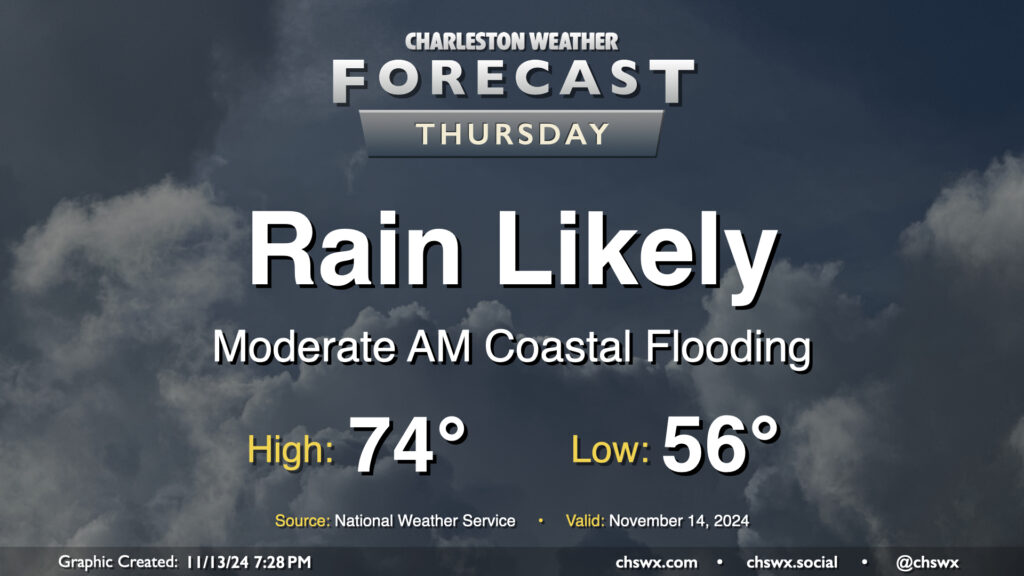
Thursday: Moderate coastal flooding in the morning with some showers during the day

Thursday figures to be a somewhat wet day at times across the Lowcountry, starting with salt water flooding downtown and ending up with showers across much of the area by evening.
First, the salt water flooding: Water levels around 7.9′ MLLW are expected with the 6:07am high tide Thursday. This will produce fairly widespread coastal flooding in downtown Charleston, and should also affect Long Point Road and parking areas around Shem Creek in Mt. Pleasant. Expect numerous road closures early on in the commute, with improving conditions heading into 8-9am. Be alert to detours around the aforementioned road closures, and never cross through floodwaters even if a road is closed — remember, this is all going to be salt water and that is incredibly not good for your car’s undercarriage!
The risk for showers should, thankfully, miss the worst of the salt water flooding. It will begin to kick up around mid-morning to midday, with the best chance of showers on Thursday afternoon into the early evening hours. Rainfall amounts should generally stay under a half-inch in most spots, but locally higher amounts are possible where heavier showers develop. Temperatures start in the mid-50s, topping out in the mid-70s early in the afternoon.
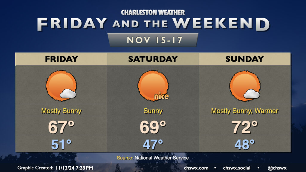
Friday & the weekend: Turning cooler and sunnier

Thursday’s meteorological inclemency gives way to a beautiful weekend as high pressure settles in over the area. Cooler and drier air will help it feel like, well, November, despite mostly sunny skies throughout. Temperatures start in the low 50s on Friday, warming to just the mid-to-upper 60s in the afternoon as the aforementioned cool advection takes place. Saturday figures to be a very nice mid-November day, with temperatures in the upper 40s yielding to highs in the upper 60s to around 70° in the afternoon under what should be a largely cloudless sky. A couple more clouds work in for Sunday, and we turn a little warmer too, with lows in the upper 40s in the morning warming to the low 70s in the afternoon. It’ll be tough to beat, though!
The risk for coastal flooding will persist, though, especially with the morning high tides. Minor flooding is expected Friday morning, but northeast flow will help drive departures back up toward the upper end of moderate flood stage (if not major flood stage) on Saturday morning. Probabilistic guidance suggests another round of moderate flooding will be possible Sunday morning, too. Coastal Flood Advisories (and perhaps Warnings) appear to be a good bet, so keep an ear out for those especially if downtown is in your plans.
Yes, @chswx is on Bluesky
Finally, many folks have been trying out the Bluesky social network in the past week as an alternative to Twitter/X. The good news is that @chswx has been operating there for the better part of a year and a half now! Feel free to follow for the daily forecast post, weather alerts originating from chswxbot, and the same breaking weather updates you’ve come to know on Twitter for the past 16+ years.
In addition to Twitter, @chswx operates on Mastodon and Instagram as well, so you won’t miss out on what’s happening with our weather wherever you might be.
Follow my Charleston Weather updates on Mastodon, Bluesky, Instagram, Facebook, or directly in a feed reader. Do you like what you see here? Please consider supporting my independent, hype-averse weather journalism and become a supporter on Patreon for a broader look at all things #chswx!