Tuesday: Quite, quite cold

A shot of cold air will drive temperatures back below freezing for Tuesday morning, with some upper 20s likely inland. The metro area should stay closer to the low 30s, but tomato, tomahto — it’s just gonna be cold. A decent northerly breeze will drive wind chills down into the mid-20s, too. Make sure you’ve got pets and plants in a safe and warm place overnight. Temperatures will struggle to the upper 40s at best in the afternoon despite plenty of sunshine, indicative of just how frigid of an airmass we’ve got to work with on Tuesday. Bundle up!
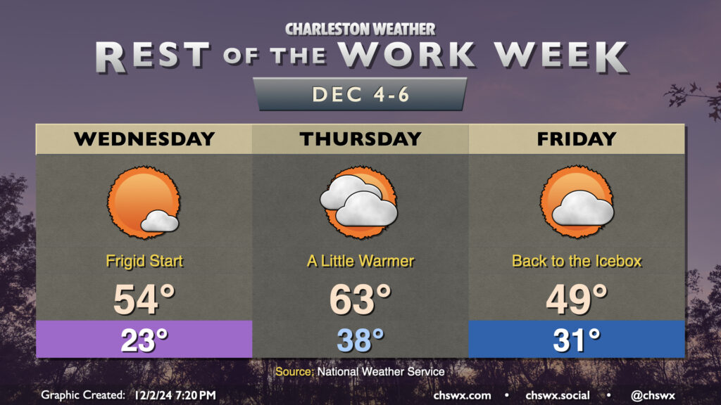
Rest of the work week: Frigid start to Wednesday, a bit warmer Thursday, then back to the icebox Friday

So let’s just get this out of the way: Wednesday morning’s chill is going to rival late January with lows expected in the low-to-mid-20s. The forecast low of 23° would match January 21 and 22 of this year, and would come in some 20° below normal. Incredibly, it would not set a record low for the date — that belongs to December 4, 1960, when the low bottomed out at 21°. Fortunately, there won’t be as much wind as Tuesday, but that’s not going to matter all that much — cold is cold, period. You’ll want to be leaving a faucet on drip overnight Tuesday into Wednesday morning, that’s for sure.
Mercifully, winds start to shift around to the southwest during the day Wednesday, so while we will get off to that heinously cold start, temperatures will recover to about the mid-50s on Wednesday afternoon. We’ll stay above freezing for Thursday as a cold front approaches and eventually moves by with just an uptick in cloud cover. Thursday still looks to be the warmest day of the week, with highs in the low 60s expected after a start in the upper 30s. This doesn’t last long, though, and we’re back at or below freezing for Friday morning, with highs once again struggling to reach 50° in the afternoon despite decreasing cloud cover.
We get one more chilly day in on Saturday, but there is at least a brief reprieve starting Sunday, with highs in the 60s expected. This continues into Monday as well. The downside will be some shower chances as moisture increases a bit, but so it goes.
Follow my Charleston Weather updates on Mastodon, Bluesky, Instagram, Facebook, or directly in a feed reader. Do you like what you see here? Please consider supporting my independent, hype-averse weather journalism and become a supporter on Patreon for a broader look at all things #chswx!