Thursday: Cooler, but still windy
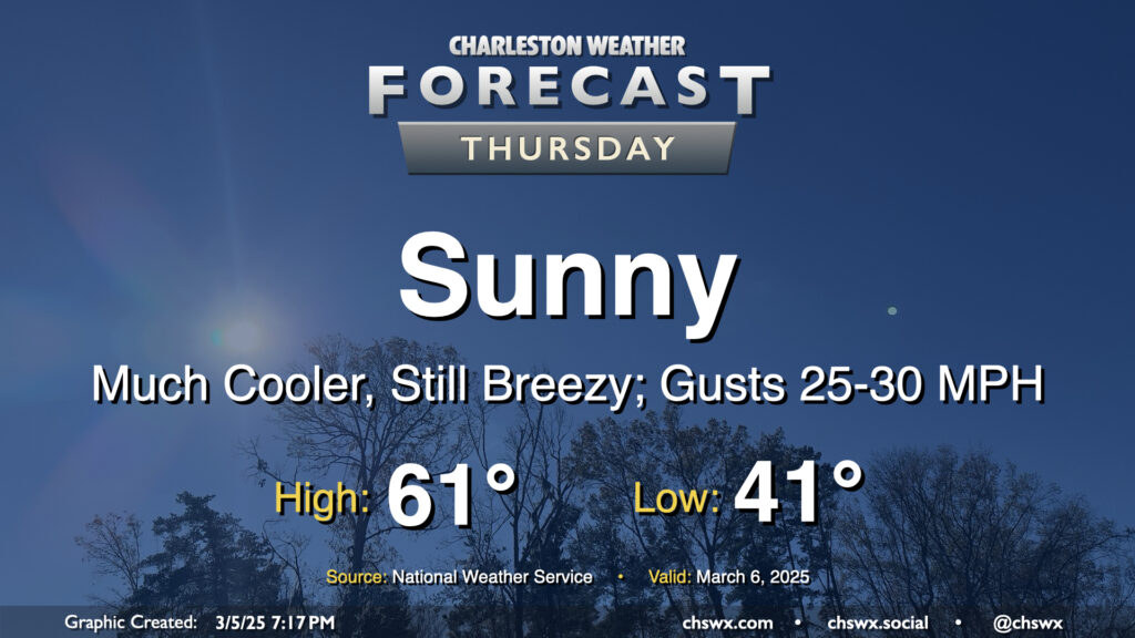
After a windy and occasionally rainy Wednesday that, thankfully, didn’t result in any severe weather, we will turn much cooler and sunnier for Thursday. Temperatures start in the low 40s, warming to just the low 60s in the afternoon with breezy conditions featuring gusts 25-30 MPH at times, particularly in the morning through the early afternoon as high pressure builds in. We’ll see that high pressure settle in a little more later Thursday night, and that will help winds go a little calmer and start to cool us off for potential frost and freeze issues inland for Thursday overnight into Friday morning.
Friday & the weekend: Temperature rollercoaster rolls on; turning unsettled Sunday
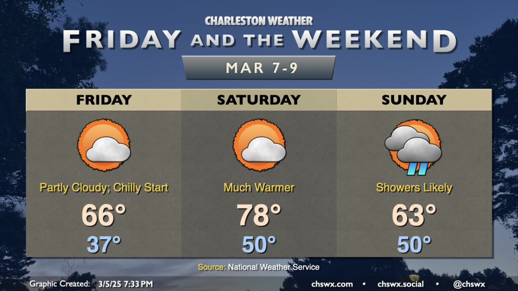
The temperature rollercoaster will certainly have its ups and downs over the next few days as another frontal system affects the area. Friday will get off to a chilly start with lows in the mid-to-upper 30s in the metro area. Lower temperatures further inland and in rural areas could, as mentioned above, contribute to some frost and freeze concerns for Friday morning. Stay alert for possible Frost Advisories and Freeze Warnings from the National Weather Service to let you know to protect sensitive plants and bring in pets. From there, though, Friday turns a bit warmer than Thursday, with highs in the mid-60s generally expected under partly cloudy to mostly sunny skies.
High pressure shifts offshore overnight Friday, and this turns temperatures much warmer for Saturday. Saturday starts around 50°, warming to the upper 70s in the afternoon as winds go back more southerly on the back side of the high. A stray shower isn’t totally out of the question, but much of us look to remain rain-free at this point. We turn much cooler on Sunday as a cold front backdoors and stalls out nearby. Temperatures start around 50° once again, but only warm to the low-to-mid-60s with the stalling front. Low pressure along the front will help kick up shower chances; while a washout doesn’t look especially likely at this juncture, some rain will certainly have an impact on outdoor plans at some point Sunday.
Wind reports from today’s storm
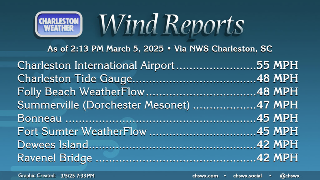
Non-thunderstorm winds ended up being more of a story than anything today as showers and a few thunderstorms moved through. Thankfully, instability was sapped by showers ahead of the main line of storms (which was losing organization at times) to keep a more substantial severe weather threat at bay. While this may have caused some inconvenience for some, the high-end potential of the event had instability materialized was certainly something that warranted concern.
The peak gust recorded in the Charleston metro was 55 MPH at the airport a little after noon as a storm moved overhead. Many stations in the metro gusted above 40 MPH, though, including the Ravenel Bridge as well as in Summerville, and these gusts persisted into the afternoon before slackening in the evening. Thankfully, no damage has been reported. Even better: there are no severe weather threats in the cards for the next several days. However, we are in that time of year where we start to see thunderstorm threats emerge, so it’s good to refresh yourselves on your severe weather plans.
Follow my Charleston Weather updates on Mastodon, Bluesky, Instagram, Facebook, or directly in a feed reader. Do you like what you see here? Please consider supporting my independent, hype-averse weather journalism and become a supporter on Patreon for a broader look at all things #chswx!