Tuesday: Triple-digit heat possible away from the coast; Heat Advisory 1-8PM
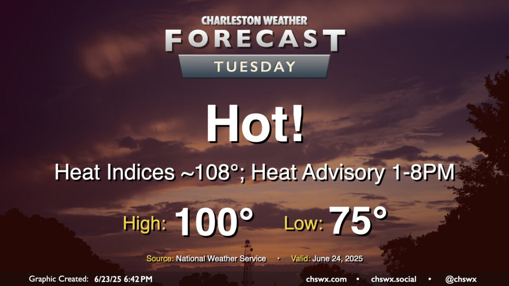
A very hot Tuesday is in the offing as high pressure at the surface and aloft remain in place, allowing temperatures to head into the upper 90s to around 100° across the area away from the coast, where temperatures should peak in the low to mid-90s. Regardless of where you are, heat indices should peak around 108-109° as well, prompting a Heat Advisory for the Tri-County area — the first of 2025 — that’ll go from 1-8 PM. If you are working outdoors during that period in particular, be sure you’re getting plenty of fluids and taking frequent breaks in the shade or, preferably, an air-conditioned environment. Be very vigilant about any children or pets in the car, too — it doesn’t take very long at all for temperatures to become very dangerous in cars, and we don’t want any hot car deaths. Look before you lock!
If a high of 100° verifies at the airport, it would be the first time since May 29, 2019 (the Before Times!) that the temperature at the airport reached 100° or higher. Triple-digit heat isn’t expected east of 17, including in downtown Charleston and at the beaches, but the closer proximity to higher-dewpoint maritime air will still send heat indices into the danger zone despite the lower air temperatures.
Looking for thunderstorms to cool you off? I wouldn’t count on it, though a stray storm can never be fully ruled out this time of year.
Rest of the work week: One more really hot day, then “cooling off” to the low 90s as storm chances tick up
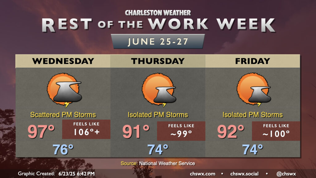
High pressure looks to break down as we get into the second half of the work week, but not before one more mid-to-upper-90s day on Wednesday. The weakening high will allow a bit more in the way of showers and thunderstorms each afternoon beginning Wednesday, so there is a bit of a better chance for some relief in there. There’s also a risk for a few stronger storms as well, so we’ll need to keep an eye on that. If we don’t get storms, it’s very possible we’re in for another Heat Advisory on Wednesday. (Pick your poison.)
Highs Thursday and Friday “cool off” into the low 90s in the afternoon, with heat indices generally around 100° each day. Isolated to scattered storms will be possible along and ahead of the seabreeze as is typical of summertime. Afternoon storm coverage should tick up a bit over the weekend into early next week, though temperatures will still soar into the 90s each day as our stretch of consecutive 90° days — which will hit two weeks on Friday — continues.
Follow my Charleston Weather updates on Mastodon, Bluesky, Instagram, Facebook, or directly in a feed reader. Do you like what you see here? Please consider supporting my independent, hype-averse weather journalism and become a supporter on Patreon for a broader look at all things #chswx!