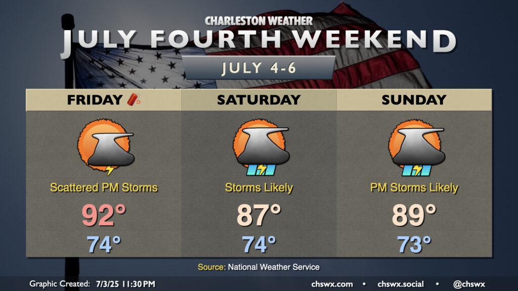
Fourth of July Weekend: A few storms Friday turn more numerous as low pressure develops offshore
The weather for the Fourth of July weekend looks a bit on the unsettled side as low pressure — perhaps tropical in nature — spins up offshore and increases the risk for rain near the coast.
Independence Day itself looks okay with a bit of drier air working into the area in the wake of a stalling front. There’s still enough juice for a few thunderstorms along and ahead of the seabreeze in the afternoon, so be sure you have indoor alternatives to your outdoor plans just in case thunderstorms threaten. Temperatures start in the mid-70s, warming to the low 90s in the afternoon. Heat indices will run in the mid-90s to around 100° in the afternoon, particularly in the immediate wake of the seabreeze, so be wary of the heat especially if you are more vulnerable to it.
Weekend: Watching for tropical development off the coast
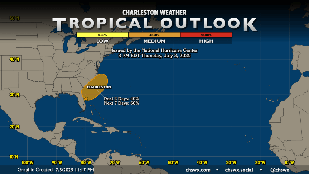
The risk for a weak tropical cyclone to kick up off the coast continues to tick up, with a 40% chance over the next two days and a 60% chance in the next seven for this to occur. If it should develop and reach tropical storm strength, it should take the name Chantal (provided something unexpected doesn’t spin up and steal it first, which seems highly unlikely).
Regardless of tropical development, the weekend forecast for the Lowcountry is generally unsettled. Numerous showers and thunderstorms are the expectation, especially the closer to the coast you get. We could see some breezy conditions on the beaches, too, with an elevated risk of rip currents as well (though with thunderstorms in the area, the water is the last place you’ll want to be). It won’t rain all the time at any one location, but when it does rain, it could turn heavy at times. By the end of the weekend, 1-2” should have fallen across a good part of the Charleston metro, with locally higher amounts. With that in mind, the more intense rainfall from this system is poised to stay off our shores.
Temperatures will be impacted a bit by the wet weather. Our streak of 90° temperatures is safe through Friday, but should come to an end Saturday after 21 days with a bit more in the way of cloud cover and rainfall expected. Sunday will run a touch warmer as the low starts to pull away and storm coverage dials back a touch, but we may still fall short of 90°. Don’t fret, though: We’ll be right back into the mid-90s starting Monday! 🙃
Follow my Charleston Weather updates on Mastodon, Bluesky, Instagram, Facebook, or directly in a feed reader. Do you like what you see here? Please consider supporting my independent, hype-averse weather journalism and become a supporter on Patreon for a broader look at all things #chswx!