Friday & the weekend: Dangerous heat wave begins
Anomalously strong high pressure builds in aloft starting Friday, bringing about the hottest weather of the year. We’ll challenge record high temperatures as well as record warm low temperatures, with heat advisories and even Extreme Heat Warnings a likelihood.
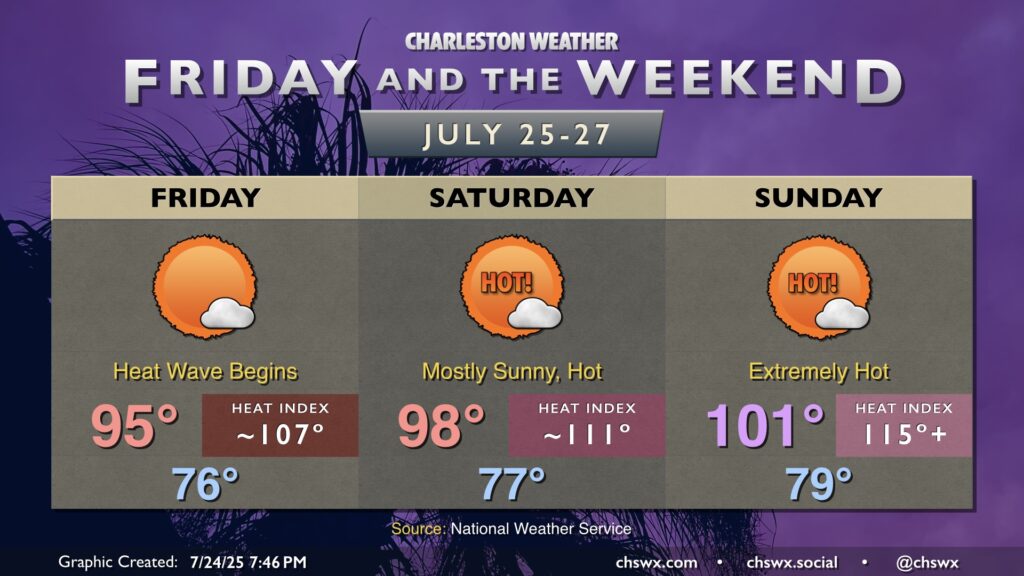
Friday will be the “coolest” day over the next several days as the ridge begins to build. We start the day in the mid-70s, warming to the mid-90s in the afternoon. Dewpoints in the mid-to-upper 70s will yield heat indices in the upper 100s, getting close to Heat Advisory criteria (heat index 108-112° for two or more hours). A stray shower or storm might pop, but I wouldn’t count on any convective relief with the strengthening ridge aloft.
The weekend will make Friday feel like an Arctic blast, though. Air temperatures head into the upper 90s on Saturday after a very warm start in the mid-to-upper 70s. Dewpoints continue to run quite warm as well, generally in the mid-to-upper 70s, and that will drive heat indices over 110° in the afternoon. Sunday’s air temperature may tie or break the daily record, soaring toward and perhaps beyond the century mark after an extremely warm start near 80°. Heat indices in the afternoon should push 115°, and we may see an Extreme Heat Warning as a result.
The extremely warm low temperatures won’t allow for much in the way of relief, either — and combined with dewpoints in the upper 70s, we may deal with heat indices in the 90s even overnight, especially near the coast. Heat stress is cumulative, and this will be particularly dangerous for those of us who are more vulnerable to the heat. Please check on those vulnerable people, including the elderly and those without air conditioning.