[Updated] Thursday: Another Extreme Heat Warning day for some with afternoon storms
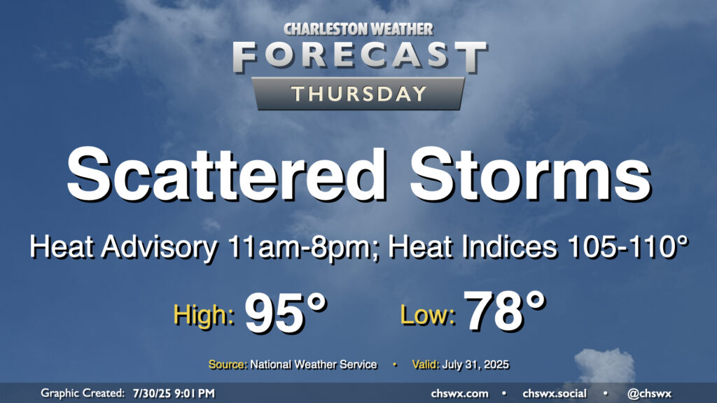
The heat wave rolls on into Thursday as we continue to sit between low pressure to the west and high pressure over the Atlantic, funneling warm and humid air into the area. We once again look to get off to a very warm and humid start with lows topping out in the upper 70s inland to low 80s near the coast. Temperatures will then warm to the low-to-mid-90s in the afternoon before showers and thunderstorms kick off, cooling some spots down. Daytime heating combined with mid-to-upper-70s dewpoints will drive heat indices to around 108-112° inland and approaching 116° closer to the coast. This has prompted an Extreme Heat Warning for Charleston and southern portions of Berkeley County (Hanahan, Daniel Island) along with an expansion of the heat advisory inland to the rest of Berkeley and Dorchester counties from 11am-8pm. Get plenty of hydration and be sure to take frequent breaks indoors or in the shade if you are working outdoors during the heat of the day!
Expect showers and storms to kick off in the noon-2pm timeframe. Slow-moving storms are again expected, with the potential for training of rainfall over some of the same areas, yielding some heavy rain and perhaps a few more flood advisories. Lightning will also be prevalent once again, so be ready to head inside if thunderstorms approach. It won’t rain all day at any one spot, though.
Friday & the weekend: Heat wave breaks, but storms become more numerous
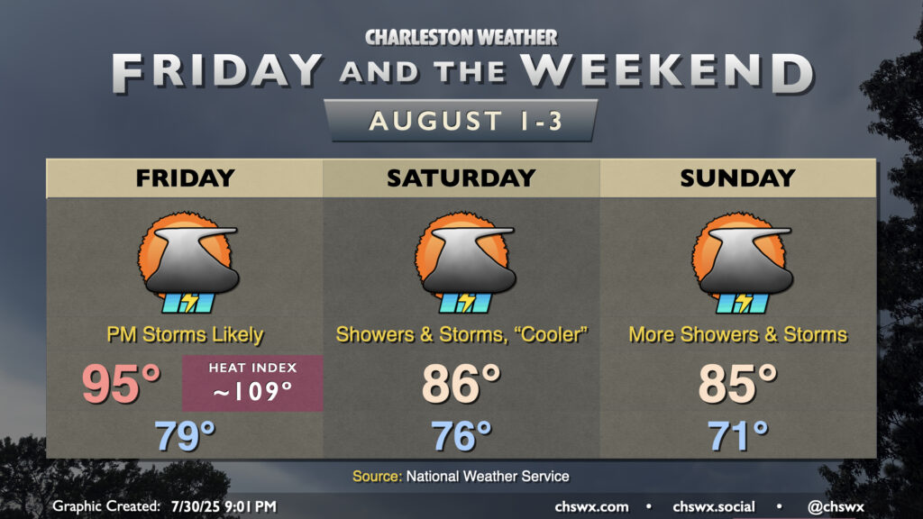
Friday will mark the last day of the heat wave and possible Heat Advisory conditions as a front approaches from the north. It’ll be another objectively hot start to the day, with lows in the upper 70s to low 80s expected once more, followed by highs peaking in the mid-90s in the afternoon. The airmass will remain very humid, and heat indices should soar once again into the upper 100s to around 110° especially near the coast. However, the incoming front will kick up storm chances Friday afternoon and into the evening, with numerous showers and thunderstorms expected to develop as the front moves southward.
The front looks to clear the area overnight Friday into Saturday, stalling out just to our south. This will usher in a break from the high heat for the weekend into early next week. It’ll cost us, though, and the price we’ll pay is an unsettled weekend with numerous showers and thunderstorms particularly in the afternoon as the stalled front hangs out just close enough to keep things unsettled here. There will be a risk of excessive rainfall, too, which could lead to flood advisories or even Flash Flood Warnings. However, despite the unsettled weather, we’ll still notice a drop in dewpoints which may feel somewhat refreshing in the wake of this past week’s oppressive heat and humidity. Overall, we can expect temperatures in the mid-70s to start Saturday, with low 70s on Sunday. Highs both days will peak in the mid-80s. We’ll stay unsettled for much of next week, too, as temperatures slowly rise back into the 90s by midweek.
Follow my Charleston Weather updates on Mastodon, Bluesky, Instagram, Facebook, or directly in a feed reader. Do you like what you see here? Please consider supporting my independent, hype-averse weather journalism and become a supporter on Patreon for a broader look at all things #chswx!