The week ahead: Unsettled with near-normal temperatures
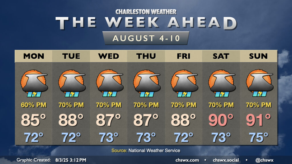
The stalled front to our south which helped bring about much more comfortable temperatures for the weekend will generally meander for the first part of the week as high pressure remains anchored well to the north, keeping our weather periodically unsettled. We’ll then transition back more toward a traditional summer pattern as we head into later in the week.
After highs only reached 80° today at the airport — the coolest day since May 25, when the high temperature was 75° — we should get back into the low to mid-80s on Monday. The cooler-than-normal temperatures will continue to keep instability in check, but scattered rains with some thunder will be possible and turning more likely in the afternoon and evening with breaks in the clouds. However, the best chance for heavy rain will remain to our south and closer to the immediate coast.
A warming trend will continue for the upcoming week, with highs returning to the upper 80s across the area by Tuesday. These highs will still run a click or two below normal for early August. Pockets of energy moving within the southwesterly flow aloft will help to instigate more showers and thunderstorms, with the best chances coinciding with daytime heating in the afternoons and evening. Periods of heavy rain will be possible, but severe weather is unlikely.
As we head into the weekend, the subtropical ridge tries to assert itself once again, with high pressure to the north slipping offshore and turning flow at the surface more southerly. This will send temperatures back into the low 90s in the afternoon, with scattered to numerous thunderstorms persisting in the forecast. We’ll want to keep an eye on the degrading frontal zone over Georgia and northern Florida as a wave of low pressure may try to develop along it. Models are, as one may expect at this range, a bit divided on the “where” and “how strong,” but most of the guidance members have something trying to get going and approach the coast. We’ll see if that ultimately turns out to be anything of consequence, but there’s evidence to suggest this is more than some model noise. For its part, the National Hurricane Center gives it a 20% chance to develop over the next week. We’ll keep an eye on it for just that reason, but the concern level is pretty low at this point.
Tropical outlook: Three areas to watch as August begins
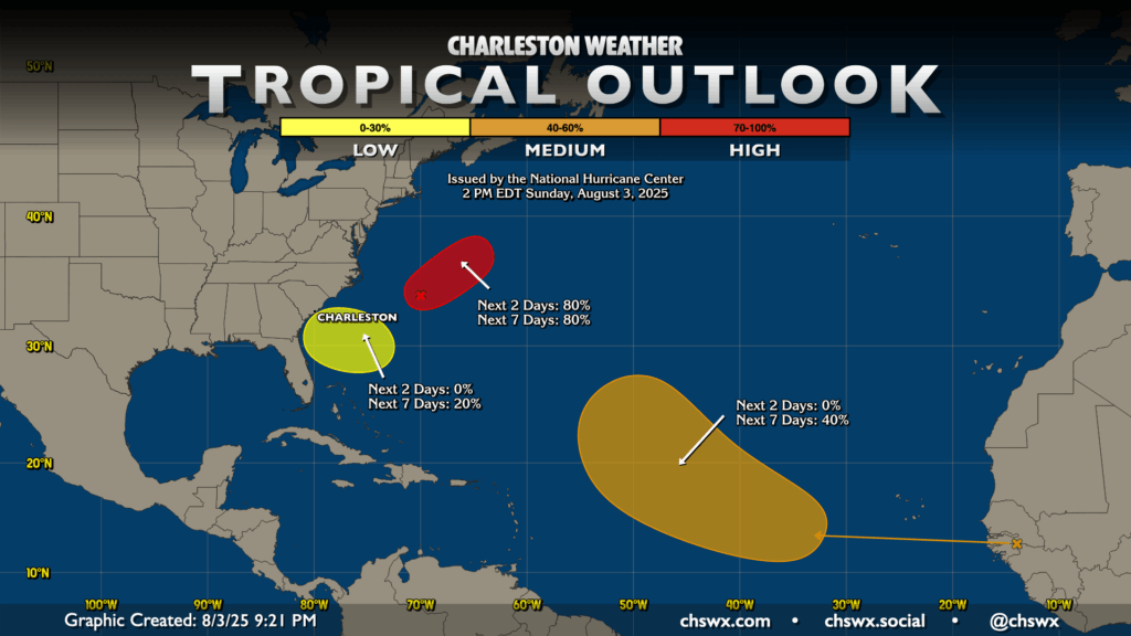
We typically start to see the tropical Atlantic start to get going in August, and the outlook map certainly reflects this. The first area, an area of low pressure along the stalled front well off the North Carolina coast, certainly has the look of at least a subtropical cyclone as of this writing. NHC gives it an 80% chance to develop in the next couple days, and it’s possible that we might have our next tropical depression or even Tropical Storm Dexter by Monday. This poses no threat, though, as it will be moving away from land.
The second area of note just off the Georgia and South Carolina coasts is the aforementioned low pressure wave for this weekend. As mentioned, NHC has this at a low (20%) chance to develop later this week/into the weekend.
Finally, we are getting into the part of the season where we start to look a little further out into the Atlantic for waves coming off the coast of Africa. One such wave has a 40% chance to develop into a tropical cyclone later this week, but the pattern supports recurvature well before it becomes an issue for us.
Follow my Charleston Weather updates on Mastodon, Bluesky, Instagram, Facebook, or directly in a feed reader. Do you like what you see here? Please consider supporting my independent, hype-averse weather journalism and become a supporter on Patreon for a broader look at all things #chswx!