Rest of the work week: Staying unsettled, turning a touch cooler again
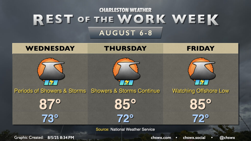
The rest of the work week will remain unsettled as the frontal zone that’s been hanging around for several days begins to trek back toward the coast, cooling us back off a little bit but keeping showers and thunderstorms in the forecast.
Wednesday starts in the low-to-mid-70s. A few showers may not be out of the realm of possibility in the morning, but as daytime heating kicks in, we should see more develop along the seabreeze and the front during the afternoon. It stands to reason that the vast majority of us will see a storm or two at some point Wednesday, but it won’t be an all-day affair, either. Highs top out in the upper 80s before storms kick in; with dewpoints remaining elevated in the mid-70s, that’ll feel closer to the mid-90s.
The front will be well to our south and offshore on Thursday, but moisture overrunning it interacting with the seabreeze will continue to keep shower and thunderstorm chances in play. It’ll run a touch cooler with northeasterly winds back in play, with highs generally topping out in the mid-80s. Shower and thunderstorm chances remain elevated for Friday as well with the status quo from Thursday generally carrying over. Once again, highs peak in the mid-80s before the seabreeze kicks things back off.
Tropics: Two areas of interest, including one off our shores
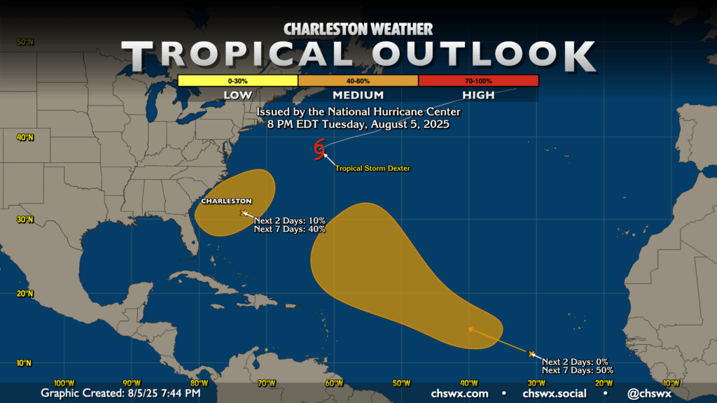
The National Hurricane Center continues to monitor a couple areas in the Atlantic for possible tropical development. Tropical Storm Dexter is also out there, continuing to move to the northeast and away from North America. Our attention over the next week will be on an area of low pressure developing along the stalled front that’ll be back offshore by the weekend. This front has already spawned Dexter and may well spawn another tropical cyclone before it’s over. Right now the odds are around 40% that this area develops in the next seven days. Models are converging on the idea that this does develop, but heads north and northeast, heading away from us. Of course, though, we will keep an eye on this in case the model consensus shifts (which can happen!)
The second area in the Atlantic is much further out, with gradual development of a tropical wave expected over the next several days. Models agree that something spins up, but there’s a lot of disagreement thereafter. We’ll keep an eye on this one, too, especially as it has plenty of runway to become a decent hurricane. For now, though, there are no imminent concerns for the Lowcountry.
Follow my Charleston Weather updates on Mastodon, Bluesky, Instagram, Facebook, or directly in a feed reader. Do you like what you see here? Please consider supporting my independent, hype-averse weather journalism and become a supporter on Patreon for a broader look at all things #chswx!