Friday & the weekend: Below-normal temperatures with unsettled periods continue
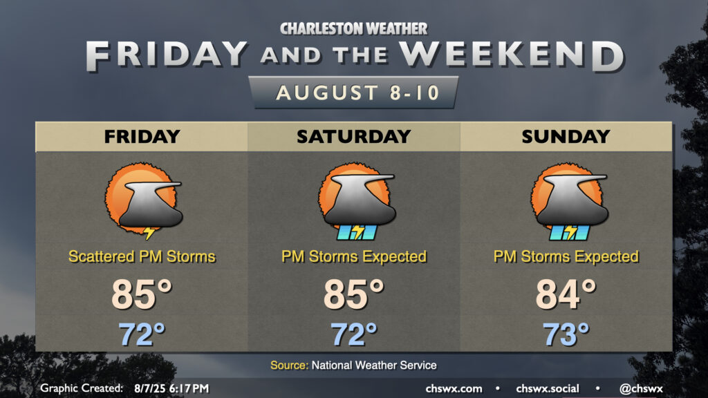
After an unusually cool and cloudy early-August day across the Lowcountry, in which highs largely did not breach 80° (good for a new record cool high temperature at North Charleston, breaking the record of 80° set just last year), we should see a bit more warmer air tomorrow as the high pressure wedge which reasserted itself today weakens a bit toward the coast. This will allow the seabreeze to get going a bit more, setting us up for an afternoon of scattered storms, with the best risk of precipitation generally east of 17-A. Lows in the low 70s will warm to the mid-80s in the afternoon — still several degrees below normal for this point in August — but it’ll still be somewhat muggy.
The weekend looks to turn even a bit more unsettled as a trough of low pressure develops overhead, further eroding the wedge and keeping showers and thunderstorms in play especially each afternoon. Temperatures will remain below normal owing to the persistent cloud cover and rainfall; expect lows in the low-to-mid-70s to warm to the mid-80s at most each afternoon. By the time the weekend is over, many of us will have gotten another inch of rain, it looks like, with locally heavier — and lighter — amounts expected, owing to the nature of convective rains.
Tropics: Things to watch, but no imminent threats
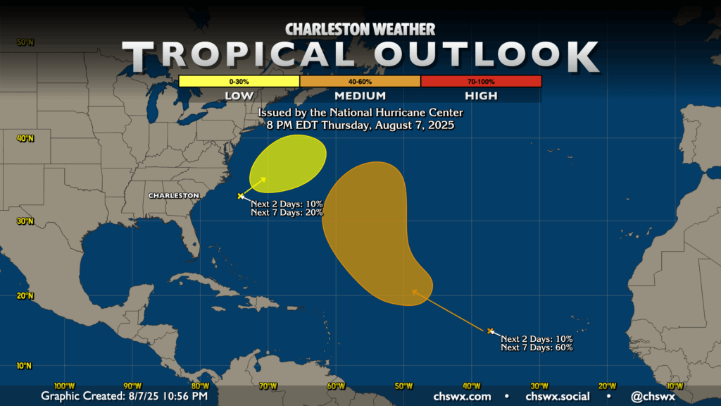
The tropics remain worth watching, but there are currently no imminent concerns for the Lowcountry. The area of low pressure which we’ve discussed previously here is less and less likely to turn tropical in nature as it moves northeastward and away from the coast; NHC’s tagged it with a 10% chance in the next two days and a 20% chance in the next seven, which is down from a peak of 40% earlier this week.
The more likely source of the Atlantic’s next tropical cyclone will come from a tropical wave in the Atlantic approaching 40°W. It’s got a 60% (or high-end medium chance) to become a tropical cyclone within the next week. Indications are, though, that it will recurve safely away before any land impacts. We’ll keep an eye on it, but this doesn’t look to be much to write home about for us.
Beyond the outlook period, there is the usual spate of fantasy hurricanes spun up by weather models (which is to be expected this time of year) but with very little run-to-run consistency to give us any confidence in what might actually happen. Images of this model output always find their way around social media this time of year, but unless you start hearing local news and weather offices begin to show concern, chances are good that it’s just clickbait. Be careful with what you share — a lot of folks have storm anxiety, and the last thing we want is to scare folks. Stay tuned to trustworthy sources of information as we get into the heart of hurricane season so you can stay prepared and properly informed.
Follow my Charleston Weather updates on Mastodon, Bluesky, Instagram, Facebook, or directly in a feed reader. Do you like what you see here? Please consider supporting my independent, hype-averse weather journalism and become a supporter on Patreon for a broader look at all things #chswx!