The week ahead: More standard summertime pattern returns
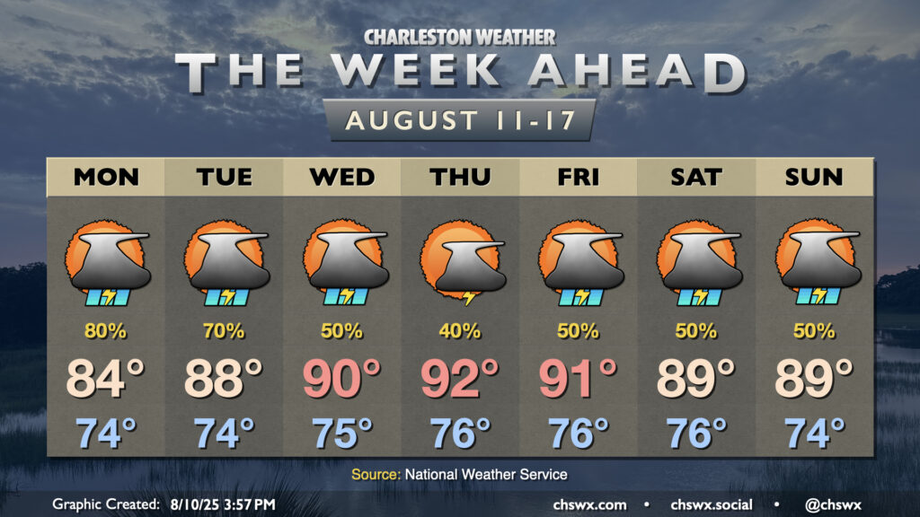
After a dreary weekend, a more standard summertime pattern returns to the Lowcountry as high pressure ridges into the area aloft, finally breaking down the high pressure wedge and stalled front that’s kept us unsettled (but at least on the cool side).
But first, we need to get through Monday, which should continue to feature unsettled weather as the coastal front moves ashore as a warm front during the day before dissipating. Temperatures start on the mild side, generally running in the low-to-mid-70s, with the potential for some showers to be in the area to start the day. The risk will continue for showers and thunderstorms into the evening, though coverage will decrease as we wind Monday to a close. The atmosphere will still be conducive to very heavy rainfall in spots, but it remains to be seen if NWS will extend the currently-going Flood Watch into Monday.
The atmosphere remains juicy on Tuesday, but with the dissipation of the front, we’ll start to look more for the traditional summertime triggers for showers and thunderstorms, primarily around the seabreeze. Temperatures will rise into the upper 80s to near 90° in the afternoon, so we’ll have more instability available for more in the way of thunder and gusty winds than we’ve had in previous days.
Temperatures continue to rise as we head into mid-week, with a return to the 90s expected by Wednesday that lasts through at least Friday. Heat indices will also be headed back into the 100s, but right now, the expectation is that they stay shy of the Heat Advisory criteria of 108°. Scattered to occasionally numerous showers and thunderstorms will be possible each afternoon along and ahead of the seabreeze, with the potential for a couple of those storms to be on the strong side. (At least we’ll get some sunshine, for a change!)
Tropics: First Atlantic hurricane of the season possible this week
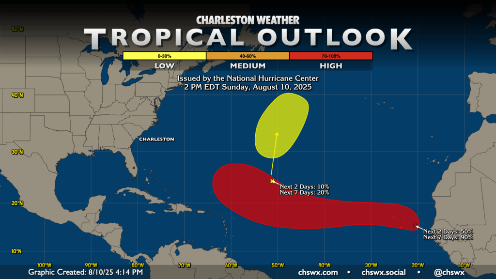
As we get further into August, we look further east into the Atlantic for tropical development, and sure enough, we’ve got a wave off the coast of Africa that has a good chance to become the first hurricane of the season. NHC is giving this area a 50% chance to develop in the next couple days, with a near-lock 90% chance for development over the next week as it generally moves westward. As usual, there’s a lot of social media talk around this particular system, with lots of Scary Model Runs being shared, but it’s important to remember that beyond 5-7 days, predictability tanks. We have plenty of time to watch this system to see where it will end up, so the important thing is to stay close to trustworthy sources of weather information. If something becomes an issue, we’ll let you know!
A second area in the central Atlantic has a low chance to develop over the next few days, but it is headed north and will stay out to sea.
Follow my Charleston Weather updates on Mastodon, Bluesky, Instagram, Facebook, or directly in a feed reader. Do you like what you see here? Please consider supporting my independent, hype-averse weather journalism and become a supporter on Patreon for a broader look at all things #chswx!