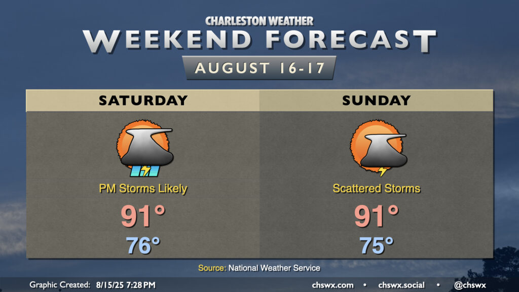
Weekend forecast: A bit stormy at times Saturday, less so Sunday
More storms are in the offing for Saturday as a front slides southward across the area, eventually stalling out across Georgia. This front, though, brings us a slightly cooler and drier airmass that filters into the area starting Sunday.
We’ll have another warm and humid start Saturday across the area, with lows generally in the mid-to-upper 70s to start. We’ll warm to around 90-91°, with heat indices in the low-to-mid-100s before showers and thunderstorms initiate along and ahead of the seabreeze in the afternoon. Storm motions won’t be terribly fast, and despite the frontal passage, there will still be plenty of moisture to wring out of the atmosphere. This combo will set the stage for perhaps a bout or two of minor flooding where these storms set up, so that’ll be something to watch as you head out and about on Saturday.
High pressure ridges back in on Sunday, and that should lead to generally less in the way of afternoon thunderstorms (but likely won’t squelch them entirely). Northeasterly flow will also help to knock dewpoints down a few pegs, so it should feel a little better (but still quite warm) outside. Generally, expect lows in the low-to-mid-70s to yield to highs around 90° in the afternoon.
Tropics: Erin becomes first hurricane of the season
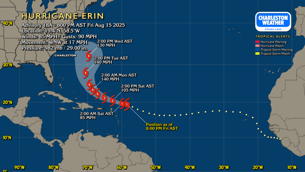
Erin became the first hurricane of the 2025 Atlantic hurricane season today, and it is steadily gaining strength as it makes a close approach to the Leeward Islands. As of 8PM, maximum sustained winds were up to 85 MPH and minimum central pressure was down to 982 millibars. Erin is expected to take a more northwesterly turn over the weekend, followed by a turn to the north as it perilously splits the uprights between the East Coast and Bermuda. While this spares us direct impacts from the storm, rip currents and rough surf will become significant issues at the beaches starting early next week and lasting through at least mid-week if not beyond.
Elsewhere in the tropics, an area of disturbed weather is coming ashore in Mexico; Hurricane Hunters found no evidence of a circulation, and it’s not likely to attain one before landfall. Other than that, we watch the typical wave train off Africa, but no other concerns are expected right now.
Follow my Charleston Weather updates on Mastodon, Bluesky, Instagram, Facebook, or directly in a feed reader. Do you like what you see here? Please consider supporting my independent, hype-averse weather journalism and become a supporter on Patreon for a broader look at all things #chswx!