The week ahead: Erin passes to our east, bringing coastal hazards
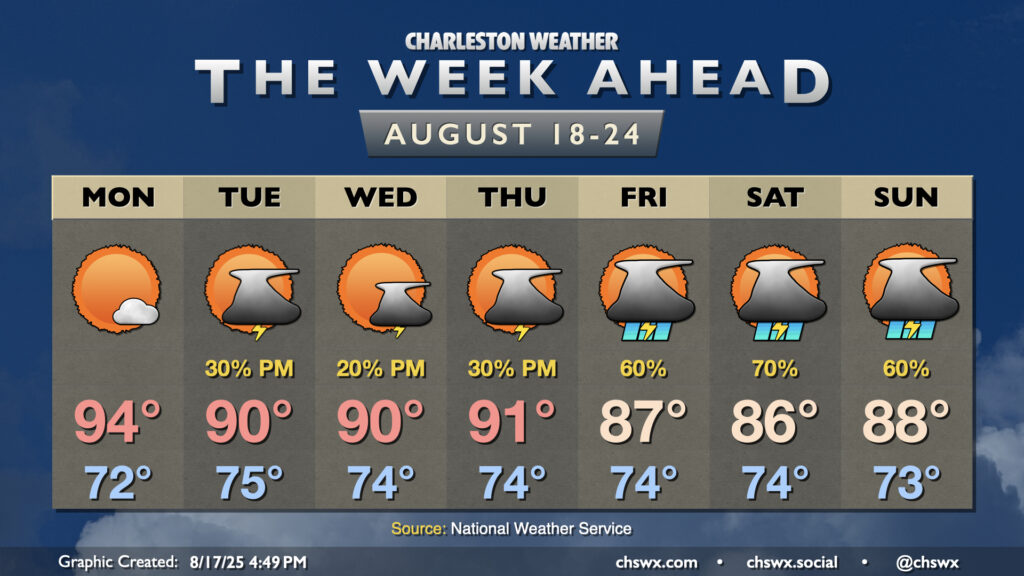
The week ahead starts out on a warm note with high pressure in play before turning more unsettled by the time we get into the weekend. Meanwhile, Hurricane Erin will be passing offshore, sparing us direct impacts but kicking up high surf, a risk for dangerous rip currents, and even some coastal flooding in the evenings.
Monday looks to be a fairly quiet weather day across the area with high pressure in control aloft. The seabreeze would be the main game in town for kicking off any thunderstorm activity, but there doesn’t look like there will be much of that to speak of for a change. Lows in the low 70s will warm to the mid-90s in the afternoon as a result, but dewpoints around 70° courtesy of the north and northeasterly flow in place will keep heat indices relatively tame, only rising a couple degrees or so above the air temperature.
Isolated to scattered storm chances return Tuesday through Thursday as disturbances aloft ripple through as a front gets hung up in the Carolinas. Dewpoints get a few degrees warmer, which should help drive the risk for showers and storms, but the resulting cloud cover keeps highs generally around 90°. It’s during this time, too, that the risk for coastal impacts — deadly rip currents, high surf, and coastal flooding — will be maximized as Erin and its expected massive wind field makes its closest approach (though staying over 500 miles offshore).
Erin will continue to head north and northeast away from the mainland as we head into the weekend. Moisture returns to the area as a result — the northerly flow around Erin will be a big part of our mid-week weather staying reasonably tame — and the risk for showers and storms will increase. Temperatures will struggle into the mid-to-upper 80s each afternoon with the onset of scattered to numerous showers and thunderstorms, which may once again pack heavy rain that could cause localized flooding.
Tropics: Erin to expand and intensify further, while another low may try to follow it later this week
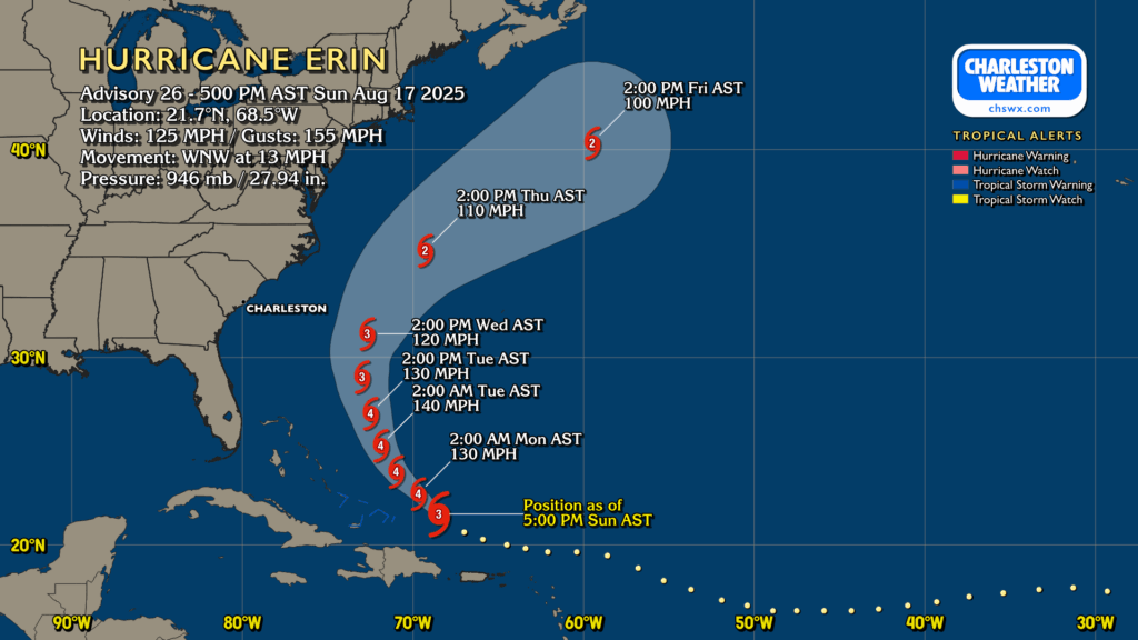
Hurricane Erin peaked at Category 5 strength yesterday, but eyewall replacement has been ongoing, which has taken the maximum wind speeds down a few notches. However, Erin remains a formidable and growing hurricane — the eyewall replacement process also expands the wind field — and should reintensify to a category 4 storm by Monday. It will also be increasingly turning northwest to northward around high pressure to its east. It may have a close shave with Bermuda, and some gusty winds may not be off the table on the Outer Banks, either. As mentioned earlier, the risk for high surf and rip currents will be felt throughout the Eastern Seaboard as this large storm moves a lot of water. Shear begins to work on the storm by mid-week, though, and it gradually decreases in intensity as we head into the weekend.
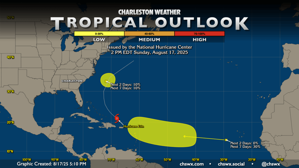
Beyond Erin, NHC is watching two other areas for development, though only one of these — the one near the Cabo Verde Islands — should come to fruition. The first area off the North Carolina coast is a bit of a naked swirl out ahead of Erin; it is highly unlikely to develop and isn’t really much of a concern (though it can be thanked for keeping Erin away from us).
The aforementioned second area near the Cabo Verde Islands has a shot to develop later this week as it heads into the central Atlantic. Right now, NHC gives it a 30% chance to develop, but I suspect that will trend higher as models have been generally in agreement on the idea that at least a weak storm develops. No matter what it is, there’s plenty of time to watch it as it will be at least a week-plus out from becoming a threat to the U.S. mainland, if it even does at all. Stay tuned, as always, as we’re getting into the traditionally busy part of the season.
Follow my Charleston Weather updates on Mastodon, Bluesky, Instagram, Facebook, or directly in a feed reader. Do you like what you see here? Please consider supporting my independent, hype-averse weather journalism and become a supporter on Patreon for a broader look at all things #chswx!