The week ahead: Generally quiet and turning a little warmer
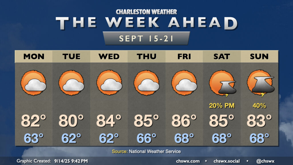
The week ahead will remain generally quiet, but we’ll start to turn warmer later this week as high pressure ridges in aloft. Slight shower and storm chances return to the area for the weekend, particularly on Sunday.
For Monday, though, another generally nice day is in the offing with lows starting in the low-to-mid-60s, warming to the low 80s under generally partly cloudy skies. We could see a brief uptick in cloud cover midday, along with even a slight shower chance, but most of us stay dry. One last round of minor coastal flooding will be possible downtown as well during the afternoon high tide, but this will be the last of this long stretch of coastal flood days as water levels generally calm down.
Low pressure will stay to the north Tuesday and Wednesday, keeping us within dry northwesterly flow to make for a few more nice days. Ridging aloft begins to build in Wednesday through Friday, and we’ll also start to see dewpoints begin to creep up as well as the low-level flow turns more onshore. This will yield highs in the mid-80s each afternoon starting Wednesday, and lows creeping back into the upper 60s by Friday.
Shower and storm chances return for the weekend with a little more upper energy in play, but coverage looks to remain generally isolated to scattered with highs generally in the low to mid-80s.
Tropics: One area to watch, but still fairly quiet
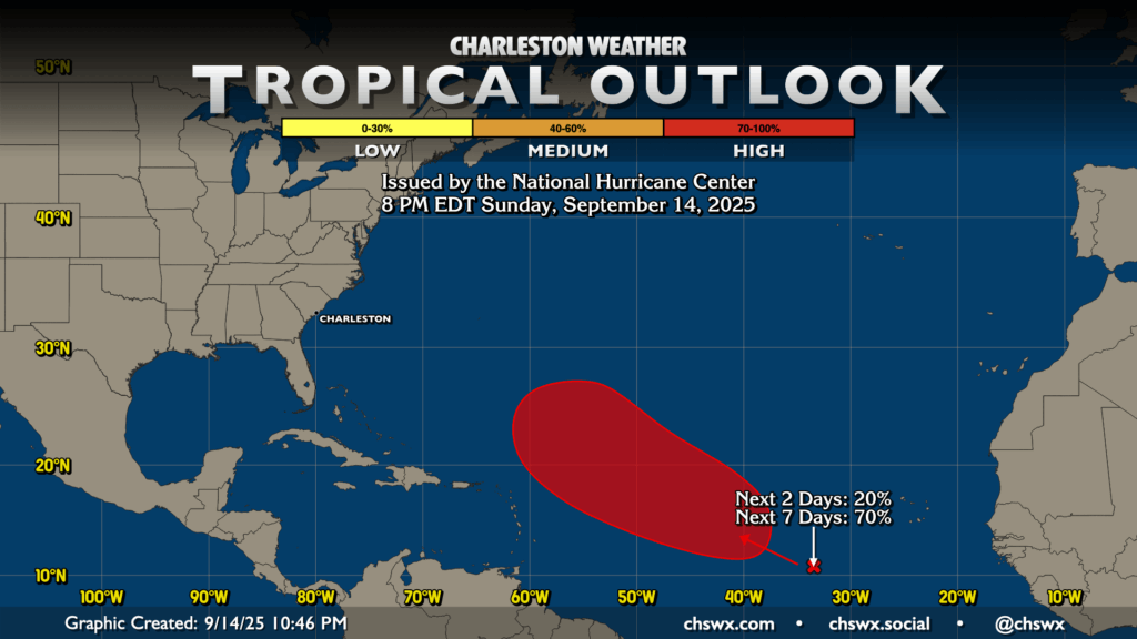
The unusual quiet in the tropics for this point in the year generally continues, though we should start to see a bit more activity in the second half of September, likely starting at some point this week as a wave off the Cabo Verde Islands continues to trek west-northwest through the Atlantic. NHC gives it a 70% chance to develop over the next week in a spot generally between 40-60°W and 10-28°N. Model guidance has been pretty solidified in something developing, and the guidance suite has also been favoring recurvature with weaknesses in high pressure over the Atlantic consistently being modeled by both physics-based and AI-based models. There’s a long time to watch this system to ensure it behaves, but for now, it’s nothing to worry about.
Follow my Charleston Weather updates on Mastodon, Bluesky, Instagram, Facebook, or directly in a feed reader. Do you like what you see here? Please consider supporting my independent, hype-averse weather journalism and become a supporter on Patreon for a broader look at all things #chswx!