The week ahead: Summer-like start to autumn with an uptick in rain chances, especially late week
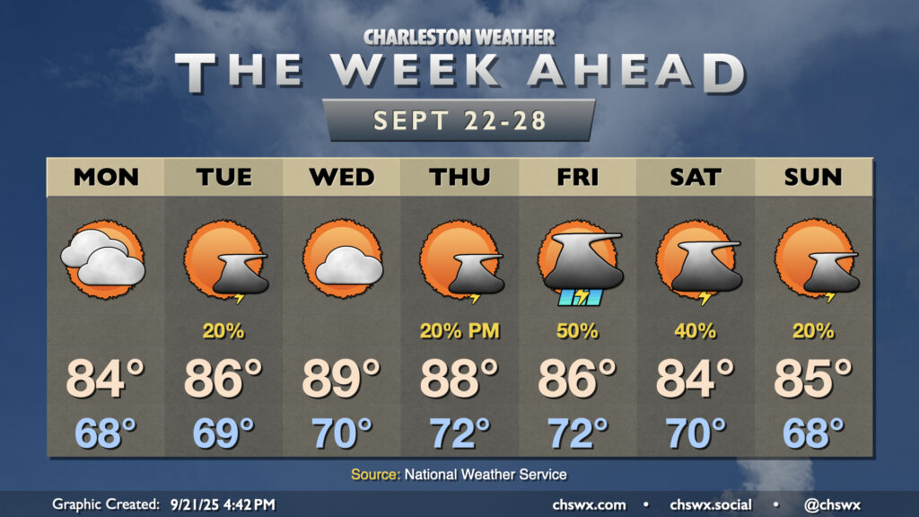
Astronomical fall begins on Monday with the autumnal equinox at 2:19 PM, but it will increasingly feel more like summer as the week wears on as above-normal temperatures take hold by midweek.
High pressure to our north will weaken on Monday, breaking down the cooler northeast flow and turning winds more southerly, which will help usher in warmer conditions over the next few days. We start Monday in the upper 60s and warm to the mid-80s under mostly cloudy skies, with a shot at some showers closer to the coast as a trough of low pressure takes shape. We’ll generally keep this going into Tuesday, with a slightly better chance of showers and storms across the metro itself with the continued troughing associated with the seabreeze. Temperatures tick up a little Tuesday, too.
Temperatures will peak Wednesday and Thursday with Atlantic high pressure in charge at the surface and a ridge of high pressure also building in aloft. Expect highs in the upper 80s on Wednesday, perhaps touching 90° in a few spots, with generally muted shower and storm coverage (though in this kind of environment, one or two showers or storms can never be totally ruled out). A cold front approaching from the west will usher in slight shower and storm chances for Thursday, with rain chances peaking Friday as the front draws nearer. The front slowly gets by Saturday into Sunday, cooling us off a bit but also keeping some rain chances in play. (No washout, though.)
Tropics: Gabrielle is the season’s second hurricane, with a couple more areas to watch over the next week
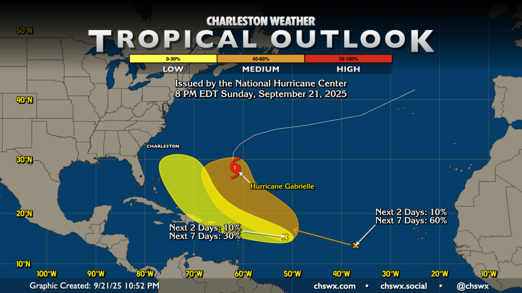
The Atlantic season has its second hurricane of the year in Gabrielle as of today. As of the 11PM advisory, it’s moving NW at 12 MPH with maximum sustained winds of 75 MPH. It’s forecast to turn more northerly and then northeastward, but with a period of rapid intensification expected on Monday that should take it to major hurricane status briefly as it passes east of Bermuda. It does not pose a threat to the continental United States outside of an enhanced rip current risk along the Mid-Atlantic coast.
There are two other areas of interest in the Atlantic. The first one, which is approaching 40°W, has a 60% chance of developing into a tropical cyclone in the next week. The second one, which is closer to the Leeward Islands, has a lower chance to develop, but is still worth watching as it is a little closer to home. There’s still decent model disagreement with how these waves ultimately take shape over the next few days. For now, they’re worth watching but far from anything to be overly concerned about. We’ll let you know if that changes.
Follow my Charleston Weather updates on Mastodon, Bluesky, Instagram, Facebook, or directly in a feed reader. Do you like what you see here? Please consider supporting my independent, hype-averse weather journalism and become a supporter on Patreon for a broader look at all things #chswx!