Rest of the work week: Warm, turning unsettled
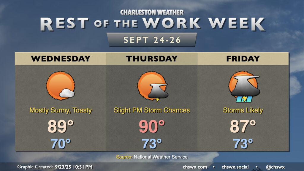
Warmer-than-normal temperatures will persist for the next few days, especially ahead of a cold front that will bring some fairly solid rain chances to the area for the first time in a little while on Friday.
First, though, we’ve got a quiet weather day ahead on Wednesday with ample sunshine and plenty of warmth. Lows will only fall to about 70° or so across much of the metro, with even warmer lows near the coast. Highs will top out in the upper 80s. Ridging aloft should keep a lid on any shower or thunderstorm activity. Thursday will start even warmer, with lows in the low to mid-70s warming to around 90° in the afternoon. There will be a slight chance of a few storms in the afternoon ahead of an approaching cold front, but most of us, particularly closer to the coast, should stay rain-free one more day. This should change Friday as the front moves through, with showers and storms likely in the afternoon. Temperatures stay on the warm side of normal, though thunderstorms will keep highs from peaking as high on Friday as they did on Thursday. We’ll keep shower and storm chances going into the weekend, too, as the front stalls out nearby.
Tropics: Looking increasingly busy by the weekend
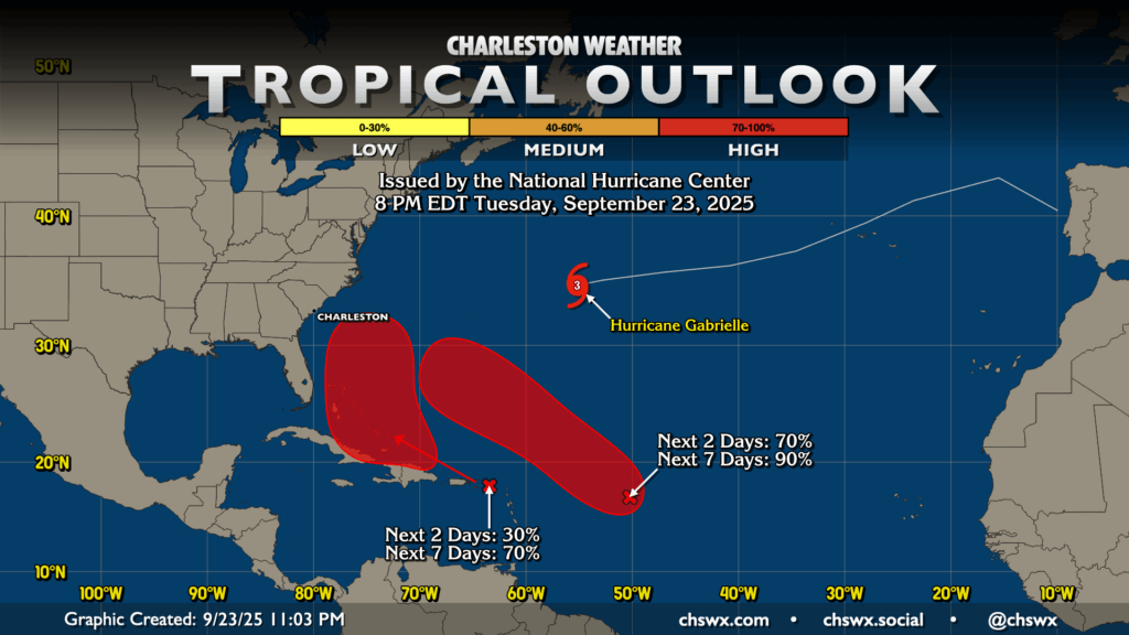
Despite being past the climatological peak of the season, the tropical Atlantic has certainly woken up. Hurricane Gabrielle is headed to the Azores over the next few days, while two other areas of interest percolate. The easternmost wave, designated Invest 93L, should become a tropical depression in the next couple days as it moves northwestward across the Atlantic, while the westernmost wave, which has been designated as Invest 94L, could become a tropical cyclone later this week into the weekend. While 93L should stay out to sea, 94L is a little more interesting because of its proximity to the East Coast and is worth a little heightened attention as a result. Models are very, very divided over how these storms evolve, so we will need to watch closely. For its part, NWS will be launching weather balloons every six hours at its upper-air sites across the Southeast and Mid-Atlantic to get more upper-air data into the models, which should hopefully help us better understand how things are evolving and make the models more accurate. For now, it’s still nothing to be overly worried about, but is certainly worth monitoring. Stay tuned…
Follow my Charleston Weather updates on Mastodon, Bluesky, Instagram, Facebook, or directly in a feed reader. Do you like what you see here? Please consider supporting my independent, hype-averse weather journalism and become a supporter on Patreon for a broader look at all things #chswx!