The week ahead: A stormy start followed by a touch of fall
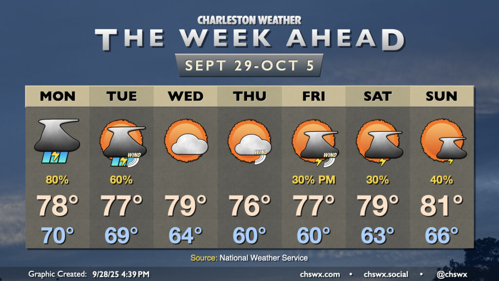
We’ll close September on a stormy note as moisture from Tropical Storm Imelda interacts with a stalled front/trough situated along the coast to produce solid shower and thunderstorm chances through Tuesday. From there, a good shot of fall welcomes us to October before more shower and storm chances return for Friday and the weekend.
While Imelda will stay well off our shores, it will still put its imprint on our weather for a few days, with the pressure gradient between its area of low pressure offshore pinching between high pressure to our northwest to drive gusty winds, particularly at the coast, for Monday and especially Tuesday as Imelda makes its closest approach before turning ENE. Gusts 20-30 MPH will be common, so be ready to hold onto your hats a little bit. Nothing damaging is expected, though.
Showers and thunderstorms will develop and move inland from the east and northeast Monday into Tuesday. We’ll see those storms taper off Tuesday as Imelda starts to pull away and drier air starts to work its way in. We’ll certainly feel it on Wednesday morning with lows bottoming out in the mid-60s for the first time in a little while, warming to near 80° in the afternoon under partly cloudy skies. Thursday will run even cooler, with lows around 60° in the morning and highs peaking just in the mid-70s with another round of partly cloudy skies. We’ll still have a bit of a northeast breeze to contend with as the pressure gradient remains tight between the departing Imelda and Humberto and high pressure wedging in to the east of the Appalachians.
Shower and storm chances return for Friday and the weekend as a little more moisture starts to overrun the high pressure wedge a little bit. Temperatures will gradually start to warm heading into the weekend, too, with some of that warmer and moist air moving in. We will still stay on the cooler side of normal, though, with highs in the 70s Friday and Saturday and just touching the low 80s on Sunday.
Imelda: Still on course to pull away
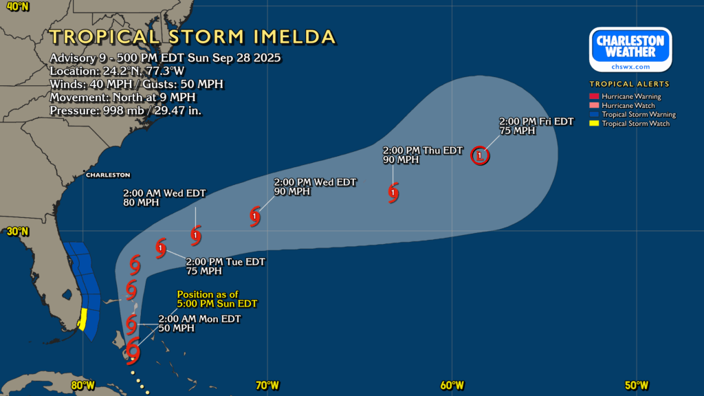
Imelda strengthened into a tropical storm earlier today a little later than first expected, but the track forecast remains solidly in place, with a sharp right turn expected on Tuesday off the central coast of Florida. From there, Imelda will strengthen into a hurricane as it moves east and northeast before interacting with a front by the end of next week, which will weaken it and start its transition to a post-tropical cyclone. We’ll keep an eye on Imelda to make sure it behaves, but we don’t really have too much to worry about.
There will be some rough surf and rip currents to contend with from both Imelda and Humberto, making for some treacherous conditions in the Atlantic waters. We’ll also see the potential for some coastal flooding with Wednesday evening’s high tide. However, the flood threat has trended lower given the storm likely making the turn off the coast of Florida. If the turn takes a little longer to take place and Imelda draws closer than forecast, this could enhance the coastal flood threat a bit. However, this scenario seems unlikely.
Other than Imelda and Humberto, there’s no other areas of interest in the tropics right now. Would love to keep it that way, that’s for sure — just a little over two months to go in hurricane season.
Follow my Charleston Weather updates on Mastodon, Bluesky, Instagram, Facebook, or directly in a feed reader. Do you like what you see here? Please consider supporting my independent, hype-averse weather journalism and become a supporter on Patreon for a broader look at all things #chswx!