Rest of the work week: A quick shot of Fall
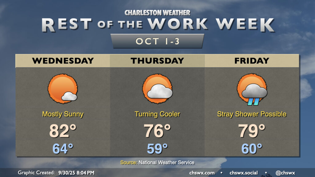
With Imelda departing to our east, high pressure will wedge down across the area, ushering in some cooler and drier air that’ll be particularly noticeable on Thursday. Shower chances return for Friday heading into the weekend, though.
Wednesday will start a few degrees cooler than Tuesday did, with lows bottoming out in the mid-60s. We’ll see much more sunshine than the previous couple days, and that’ll help drive temperatures into the low 80s in the afternoon. Winds will still be a bit breezy out of the north and northeast, which may drive water levels in Charleston Harbor into minor flood around the 3:48 PM high tide. Be alert for possible coastal flood advisories tomorrow afternoon, and be ready to reroute if water impinges upon roadways. It’ll be salt water, and that is just no good to try to drive through.
High pressure will continue to build southward into the area on Thursday as the airmass change continues. Lows should bottom out in the upper 50s away from the coast, warming only to the mid-70s in the afternoon under partly cloudy skies. Winds will remain on the gusty side, with gusts 20-25 MPH possible out of the northeast. This’ll drive another round of tidal flooding around the 4:45 PM high tide, with water levels approaching moderate flood stage. Once again, coastal flood advisories will likely be needed, and a few roads could close downtown.
We’ll see a little more in the way of cloud cover on Friday as a trough of low pressure starts to sharpen near the coast, with the risk for a few showers spreading ashore as well. However, most of us should stay rain-free. Temperatures will once again run several degrees cooler than normal, with lows around 60° warming to the mid-to-upper 70s in the afternoon. The specter of moderate coastal flooding will loom over your Friday evening downtown plans, though, with high tide peaking around 5:39 PM. Be ready for even more road closures.
Coastal flooding will continue around the evening high tides through the weekend, and may eventually become problematic with each high tide cycle by early next week. Major flooding is not off the table at some point as we approach a full moon at perigee. Stay tuned for more on this as we get into the next few days.
Tropics: Imelda and Humberto running off together
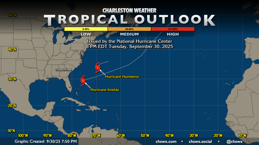
Imelda and Humberto, both Category 1 hurricanes, are heading eastward, unfortunately affecting Bermuda in the process. The storms continue to behave as forecasted, and there are no going tropical concerns here in the Lowcountry. We’ve got two months left in hurricane season, so it behooves us to maintain watch, but we’ll be through it before you know it.
Follow my Charleston Weather updates on Mastodon, Bluesky, Instagram, Facebook, or directly in a feed reader. Do you like what you see here? Please consider supporting my independent, hype-averse weather journalism and become a supporter on Patreon for a broader look at all things #chswx!