Friday & the weekend: Seasonable temperatures; rain chances return Sunday
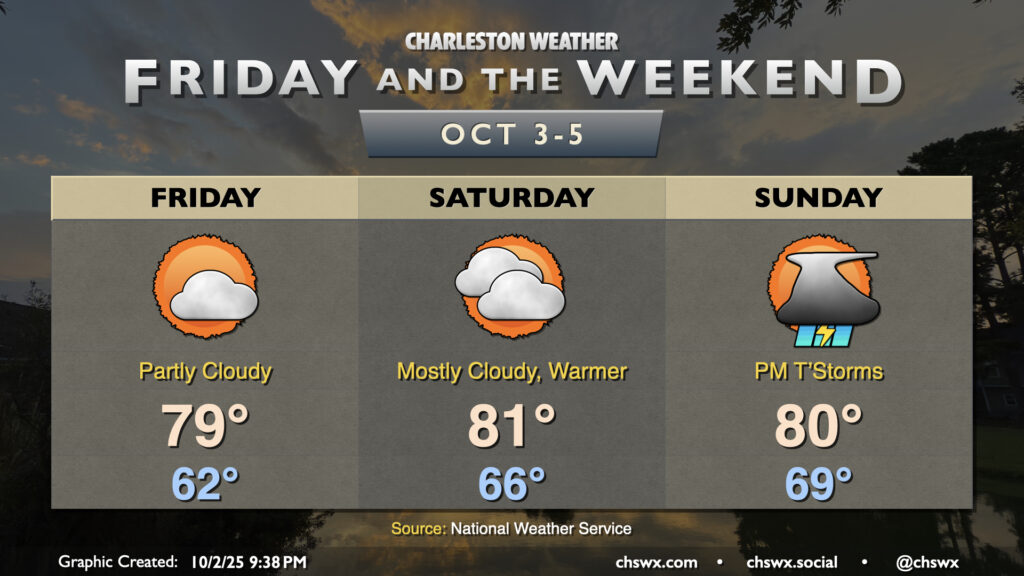
Temperatures will continue to be generally seasonable if not slightly cooler than normal for Friday and the weekend as high pressure continues to wedge southward into the area, though we will see an uptick in moisture and, eventually, rain chances heading into Sunday.
Friday starts right around normal for early October with lows bottoming out in the low 60s. The persistent northeast breeze will continue, with winds gusting 20-25 MPH at times. This combined with a mix of sun and clouds will keep temperatures generally to the upper 70s to around 80° in the afternoon. Dewpoints will run a little higher Friday than they did on Thursday, so it’ll be a touch more humid, but still comfortable.
Dewpoints continue to rise on Saturday as moisture gradually builds back in. We should see more in the way of cloud cover as well, and a stray coastal shower is probably not entirely out of the question, either. Temperatures will run a couple degrees warmer despite the cloud cover, with highs topping out in the low 80s.
As the wedge high pushes more to the east, we will see winds turn more onshore, allowing more in the way of shower activity to push inland. A few storms can’t be ruled out, either, but otherwise we’ll see periods of scattered (and, frankly, needed) rains during the day. Nothing to wipe your plans out over, but something to keep in mind if you’re headed out and about. It’ll be much warmer in the morning; lows bottom out near 70°, while highs peak around 80° in the afternoon, governed by cloud cover and periods of showers and storms.
Coastal flooding issues will continue into next week
We had a round of minor coastal flooding on Thursday evening, with water levels peaking around 7.08′ MLLW at 5:24 PM. The persistent northeasterly wind and upcoming full moon at perigee will keep the risk of coastal flooding going well into next week. Expect another round of minor to possibly moderate flooding Friday evening generally from about 4-7 PM, which should be enough to close a few roads downtown. The Saturday morning high tide just before 6 AM will get pretty close to flood stage, while we should see minor flooding between 5-7 PM. Sunday morning’s high tide will get there, with the evening high tide potentially approaching moderate flood once again as the astronomical effects start to kick in. Expect flooding with each high tide thereafter for at least the first part of the week. Remember: This is salt water, and is unkind to your car’s undercarriage. Turn around if you approach a flooded road.
Tropics: Two areas to watch
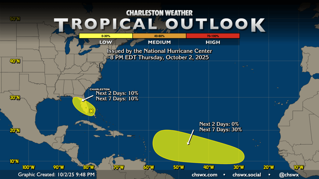
Imelda and Humberto are no more (as tropical cyclones, anyway), with the final advisories on Imelda having been written yesterday. From there, we have two areas of interest in the Atlantic with low probabilities of tropical development over the next week. The first area, generally found right over Florida, comes courtesy of the potential for low pressure to spin up on a stalled front. The land interaction will certainly make things tricky for tropical development, and the National Hurricane Center is giving the area a 10% probability to develop over the next few days as it heads into the Gulf. Given the proximity, we’ll keep an eye on it, but there’s not much to be overly concerned about right now.
A second area is highlighted in the south central Atlantic between the Cabo Verde Islands and the Leeward Islands. The wave in question has not yet moved off the coast of Africa, but NHC says that as it does so, it will potentially combine with another wave. This combined area could then move into more favorable conditions for development later in the weekend or early next week. There’s plenty of time to watch this area as well, and so far nothing to be overly concerned about here, either. Less than two months to go…we can do this!
Follow my Charleston Weather updates on Mastodon, Bluesky, Instagram, Facebook, or directly in a feed reader. Do you like what you see here? Please consider supporting my independent, hype-averse weather journalism and become a supporter on Patreon for a broader look at all things #chswx!