The week ahead: Warm start, but another shot of fall for the weekend
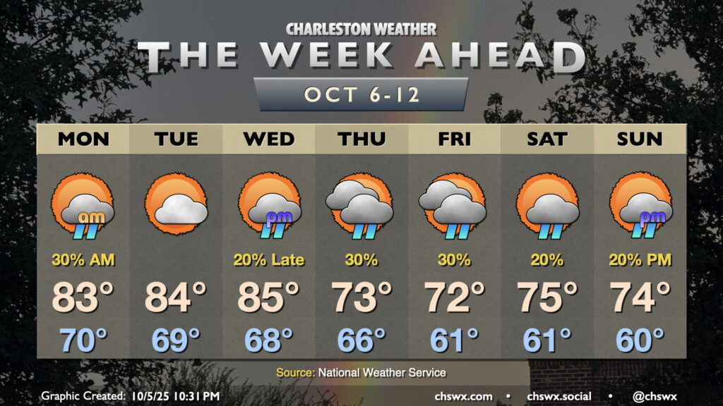
Warm temperatures will continue for the first half of the week before a cold front knocks temperatures down below normal starting Thursday. Shower chances will be with us for much of the week, though, and we’ll be dealing with coastal flooding as well.
Showers will move in from the Atlantic overnight into Monday morning, especially near the coast, as a trough of low pressure persists just offshore. Showers diminish as the day goes on, and we should see temperatures warm to the low-to-mid-80s after a low around 70°. We turn even a little warmer Tuesday into Wednesday as high pressure nestles in a little closer. Tuesday should be mostly rain-free, but a stray shower is not out of the question. Warmth then peaks Wednesday with highs in the mid-80s a solid bet. Some showers may arrive late ahead of a front.
The aforementioned front will turn temperatures sharply cooler. Highs on Thursday should run about 10-12° below where they did on Wednesday, with low to mid-70s temperatures expected as cooler high pressure builds southward. Showers will be possible across the area in the wake of the front as Atlantic moisture will overrun the high, but don’t expect much in the way of rain totals as the moisture is generally limited. We’ll keep the cooler air with occasional shower chances going into the weekend.
Coastal flooding threat continues, especially late week
The risk for coastal flooding around times of high tide will continue for much of the rest of the week. The full moon arrives late Monday night, and it’ll be in “supermoon” territory as it passes closest to earth on its orbit. This will continue to drive the risk for minor to moderate flooding with each high tide. As winds kick back up later this week, a couple 8′ tides may not be out of the question, so we’ll need to monitor this closely. Stay alert for coastal flood advisories from the National Weather Service.
Tropics: Invest 95L likely to develop soon, but looks to stay away
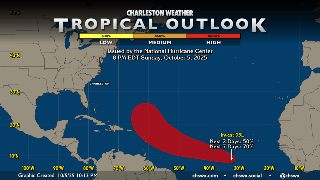
Finally, we have one area of interest in the tropics: Invest 95L that is just southwest of the Cabo Verde Islands. It’s increasingly looking likely that this will develop into a tropical cyclone early next week as it moves west-northwest. However, the preponderance of the evidence suggests that this will be a non-factor for our local weather.
Follow my Charleston Weather updates on Mastodon, Bluesky, Instagram, Facebook, or directly in a feed reader. Do you like what you see here? Please consider supporting my independent, hype-averse weather journalism and become a supporter on Patreon for a broader look at all things #chswx!