Tuesday: Another warm day; seasonable warmth continues
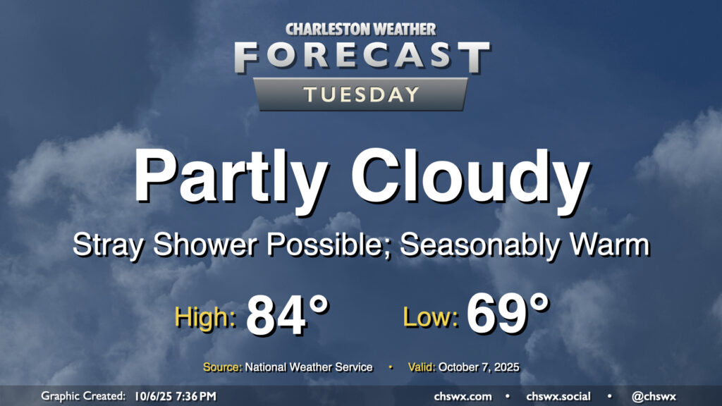
We stay warm on Tuesday with another day of high pressure at the surface and aloft driving temperatures above normal across the area. We’ll start the day near 70°, warming to the mid-80s in the afternoon under partly cloudy to mostly sunny skies. A few showers appear possible near the coast during the morning and early afternoon hours, but otherwise, many of us should get a rain-free day in.
We will need to continue to monitor the risk for coastal flooding around times of high tide, especially during the morning, with minor to moderate coastal flooding likely between 6-11 AM. (High tide peaks around 8:23 AM.) When we get into moderate flood stage, we start to run into more widespread road closures downtown, and given the timing, commute impacts appear likely. Allow extra time to reach your destination if downtown is where you’re headed in the morning. Another round of minor coastal flooding will be possible generally between 7-11 PM, which may yet close a few vulnerable roads but should not get as high as the morning high tide.
Rest of the work week: Turning sharply cooler as a front pushes through; major coastal flooding possible late week
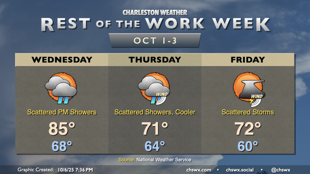
We’ll have one more day in the 80s on Wednesday before a front moves through from the north, ushering in a wedge of cool high pressure that’ll drive high temperatures down to the low 70s for Thursday and Friday afternoons for the first time since May 10 when the high temperature was 71°. The front will usher in the risk for showers beginning later Wednesday, and this will persist into the early weekend. It won’t be an all-day rain, though. Winds may be a bit more impactful, as gusts 25-30 MPH will be possible at the coast as high pressure wedges into the area and low pressure potentially spins up offshore. This surge of northeasterly wind should also drive water levels up, particularly around the morning high tides. Moderate flooding is expected Wednesday morning, with major flooding expected Thursday morning. Another round of moderate to major flooding seems probable Friday around midday, too. Stay tuned for Coastal Flood Advisories and Warnings from the National Weather Service, especially as we head into late week.
Follow my Charleston Weather updates on Mastodon, Bluesky, Instagram, Facebook, or directly in a feed reader. Do you like what you see here? Please consider supporting my independent, hype-averse weather journalism and become a supporter on Patreon for a broader look at all things #chswx!