Thursday: Turning much cooler; first round of several rounds of major coastal flooding mid-morning
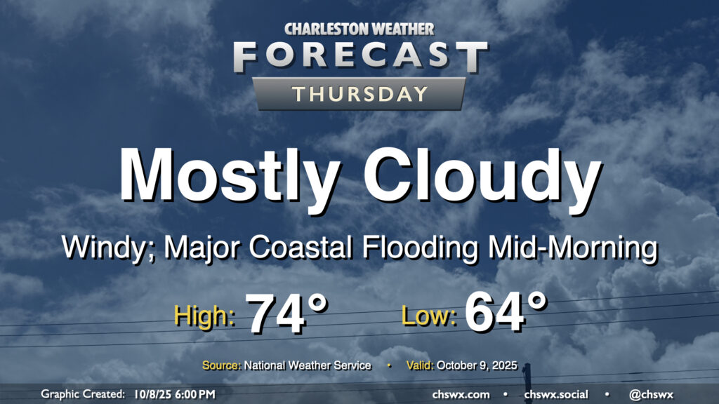
A cold front will pass through overnight, bringing with it a chance for showers and maybe even some thunder as it moves by. Behind that front will be a significant airmass change as high pressure builds southwestward into the area. We’ll wake up to lows in the mid-60s, with temperatures climbing just to the mid-70s under mostly cloudy skies. It’s going to be quite breezy, with northeasterly winds gusting 30-35 MPH at times, especially near the coast.
The strong northeasterly winds will drive water levels in the harbor quite high on top of already high astronomical tides, especially during the day on Thursday (and for the next several days). High tide will peak around 10:06 AM around 8-8.2′ MLLW, which is comfortably in the major flooding threshold. A Coastal Flood Watch is in effect and will likely be upgraded to a warning if trends continue overnight. Be ready for numerous road closures in downtown Charleston as well as salt water impingement onto roads on James and Johns Islands as well as Daniel Island. Moderate coastal flooding is expected with the evening high tide as well, with water levels peaking around 7.5-7.7 MLLW between 9 PM and midnight. This should be high enough for another round of road closures downtown, so be mindful if your travels take you there Thursday night.
Friday & the weekend: Coastal flooding threat peaks, with a top-15 tide possible Friday
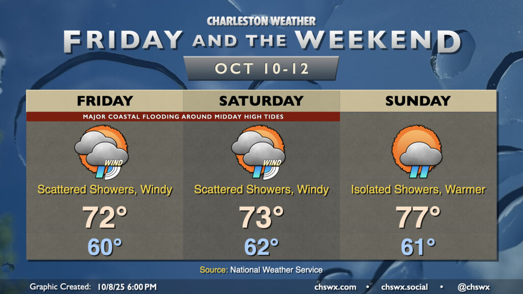
Windy and cooler-than-normal conditions will continue heading into Friday and the weekend as an early-season nor’easter develops offshore, pinching the pressure gradient between high pressure anchored to the northeast. Shower chances will persist Friday into Saturday, and will largely be governed by how close low pressure ultimately gets to the coast. The current forecast indicates some spots near the coast could get an inch-plus of rain before it’s all said and done, but we’ll see how the details ultimately work out. Regardless, gusts 30-35 MPH will be common, and this will continue to drive large tidal departures on top of already significant king tides, particularly during the midday high tides Friday and Saturday. Friday’s water level forecast is particularly concerning, with a top-15 record tide possible. NWS is forecasting between 8.4-8.6′ MLLW with the high tide that should peak a little after 11 AM. This is very comfortably in major coastal flooding territory, and we can expect numerous roads in downtown Charleston to close, with some coastal flooding impingement on James and Johns, Daniel Island, and along Long Point Rd. in Mt. Pleasant. Flooding should begin by 9 AM, with the worst between 10 AM and 1 PM.
Another round of major coastal flooding is expected with the noon high tide Saturday. Right now, it doesn’t look like it’ll be quite as severe as what we expect to see Friday, but it should still be fairly disruptive to travel downtown, especially on the edges of the peninsula. There’s a little more uncertainty, but moderate to major flooding may occur early Sunday afternoon, too. Stay tuned to Coastal Flood Watches, Warnings, and Advisories from the National Weather Service.
Follow my Charleston Weather updates on Mastodon, Bluesky, Instagram, Facebook, or directly in a feed reader. Do you like what you see here? Please consider supporting my independent, hype-averse weather journalism and become a supporter on Patreon for a broader look at all things #chswx!