The week ahead: Much more sun and pleasant temperatures
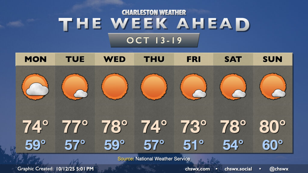
The nor’easter that has made for several soggy days across the metro will finally be pulling away on Monday, yielding a beautiful week of weather across the area with plenty of sun and comfortable temperatures.
Much of the week will feature lows in the 50s, especially as we get toward the end of the week when a reinforcing shot of cooler air briefly moves in. Monday will still run much cooler than normal, especially in the afternoon, as cloud cover diminishes on the back side of the nor’easter. We start the day in the upper 50s to near 60°, warming to about the mid-70s in the afternoon. Winds will still be a bit breezy, but the pressure gradient will be relaxing, allowing winds to come down as we get deeper into the week. The coastal flooding threat will be muted by northwesterly winds, but we could still see some salt water get on some vulnerable roads downtown with high tide around 2:12 PM. If minor flooding becomes more likely, we could see a Coastal Flood Advisory.
Mostly sunny skies will follow for the next few days as high pressure is the main weather feature. Expect lows in the mid-to-upper 50s and highs in the mid-to-upper 70s Tuesday and Wednesday. A front gets by overnight Wednesday into early Thursday, and may come along with a little bit more in the way of cloud cover, but will otherwise pass through with little fanfare. Winds will go back northeasterly, though, and high temperatures will fall to the mid-70s Thursday and Friday, with the risk for minor coastal flooding potentially returning for the evening high tide starting Thursday. It’ll also get chilly in the mornings — lows in the low 50s are expected Friday, with perhaps some upper 40s further inland.
High pressure will then begin to slip offshore over the weekend, but we should stay rain-free as temperatures start to warm back to the upper 70s to low 80s by Sunday.
Tropics: One area of note in the Atlantic, but no concerns at home
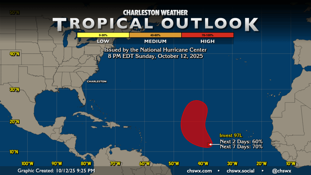
A late-season Cabo Verde disturbance has a high probability of developing into a tropical cyclone this week as it turns northwest and northward around 40°W. Guidance generally shows this staying confined to the eastern Atlantic for now, and is nothing to really be concerned over in our neck of the woods. As we get further into October, we’ll be generally keeping a closer eye on anything that can get going in the Caribbean and Gulf for potential issues, but so far, we’re looking okay in that department. A little over a month and a half to go in the season — hang in there!
Follow my Charleston Weather updates on Mastodon, Bluesky, Instagram, Facebook, or directly in a feed reader. Do you like what you see here? Please consider supporting my independent, hype-averse weather journalism and become a supporter on Patreon for a broader look at all things #chswx!