Thursday: Another warm day with dense fog possible in the morning
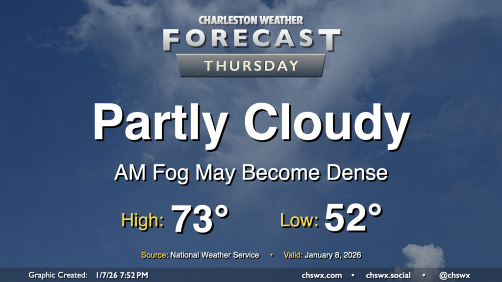
We may get another abnormally warm January day off to a foggy start across a good bit of the area as winds go calm and temperatures fall to right around their dewpoints in the low-to-mid-50s. It’s not a slam dunk that we’ll run into fog, but better to be ready for it and the associated commute delays that may come along with it.
If it develops, fog should eventually mix out by mid-morning as temperatures head into the low 70s once again under generally partly cloudy skies. It’ll be a much warmer-than-normal day — a normal January 8 should only see highs peaking around 60° — but at least the record of 81° set in 2005 will remain unchallenged.
Friday & the weekend: A couple more warm days before a front cools us off
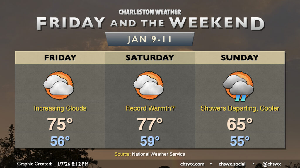
Warmth will continue as we head into the weekend, but a sharp cold front will restore some order to temperature chaos on Sunday.
Friday and especially Saturday could be days where we challenge not only record highs, but perhaps even record warm low temperatures. Friday starts in the mid-50s, and while the NWS forecast low of 56° is not a record-breaker for overnight warmth, it does get awfully close to the record of 58° set in 1946. Despite an uptick in cloud cover, we can expect Friday’s highs to top out in the mid-70s, though it’s not out of the question that we could mount a serious challenge to the record high of 78° set in 2012.
Record warmth is most likely on Saturday, especially with the morning low of 59° encroaching closely on the record warm low of 60° set in 1974. From there, strengthening southwesterly winds will pump plenty of warm air into the area, driving highs into the upper 70s and maybe even making a run for 80°. The record high for January 9 is 79°, set in 2008. Skies will continue to run partly to mostly cloudy throughout the day, which will have impacts on just how warm we can get. There will be a risk for a few showers to start arriving from the west late in the evening on Saturday ahead of the cold front.
The aforementioned front will get through the area early on Sunday, with shower chances diminishing through the morning. Temperatures Sunday will start in the mid-50s one more time, but winds shifting to the west will start to bring in cooler and drier air, capping highs to the mid-60s. Sharply cooler temperatures will follow Monday and Tuesday before moderating a bit more toward normal on Wednesday (albeit with another chance of rain).
Follow my Charleston Weather updates on Mastodon, Bluesky, Instagram, Facebook, or directly in a feed reader. Do you like what you see here? Please consider supporting my independent, hype-averse weather journalism and become a supporter on Patreon for a broader look at all things #chswx!