Thursday: Front comes through with very cold air to follow
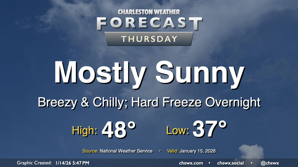
A cold front will come through early Thursday, ushering in another round of very cold and dry air to the area which may elevate fire danger during the day. We’ll start the day in the mid-to-upper 30s with a few clouds around. Those clouds will largely scour out as the drier air punches in, and it will punch in — expect winds around 10-15 MPH with higher gusts at times. The influx of cold air will limit highs to the upper 40s despite full sunshine, and with the wind, it’ll feel even cooler than that. This will lead to a hard freeze overnight Thursday into Friday morning, so you’ll want to make sure that pets, plants, pipes, and people are protected as temperatures plummet into the low 20s by Friday morning.
Friday & the weekend: A couple more ups and downs on the temperature rollercoaster, and then maybe some wintry intrigue for Sunday
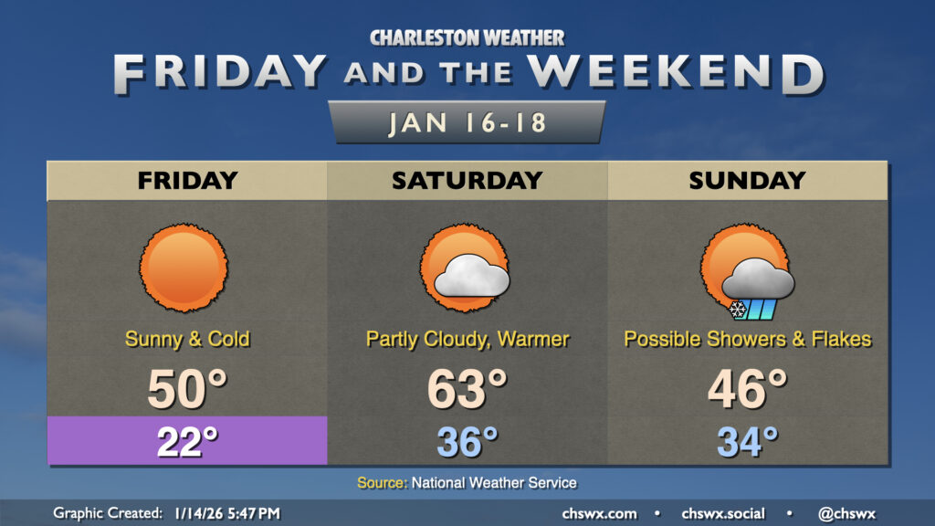
We will get Friday and the weekend off to a frigid start as lows fall to the low 20s across much of the metro, with some potential for upper teens further inland and in more rural areas. Fortunately, winds will be calming down by Friday morning, so wind chill impacts should be minimal, though we may still see Cold Weather Advisory-level wind chills (11-20°F). The airmass will moderate ever so slightly Friday, with highs peaking around 50°.
Saturday will turn much warmer as winds go southwesterly ahead of a cold front. Temperatures start in the mid-30s, warming to the low to mid-60s in the afternoon with a few clouds from time to time. Then comes Sunday’s intrigue as the cold front moves by. It’s possible some moisture may be lingering behind it, and model guidance has been hinting a little more strongly at an upper low moving south enough to instigate some precipitation. The column of air above the surface will be quite cold, and could support some snowflakes mixed with rain in the Charleston metro area. Further to the west, the probability for more snow than rain ticks up a little bit. One variable to watch, too, could be the potential for low pressure to spin up offshore, which could assist in driving more precipitation — and cooler air into the area — to support more of that potentially being frozen precipitation.
The setup is still quite precarious, especially this far out, and is very much subject to change with additional model data coming in. That being said, we’ll keep an eye on it. Regardless of how things turn out, the surface will be too warm to support any accumulation, so don’t expect really anything disruptive short of the usual traffic shenanigans when precipitation falls.
Follow my Charleston Weather updates on Mastodon, Bluesky, Instagram, Facebook, or directly in a feed reader. Do you like what you see here? Please consider supporting my independent, hype-averse weather journalism and become a supporter on Patreon for a broader look at all things #chswx!