Thursday: Warmth and sunshine peak, then turning cooler and wetter; winter weather threat moving northward
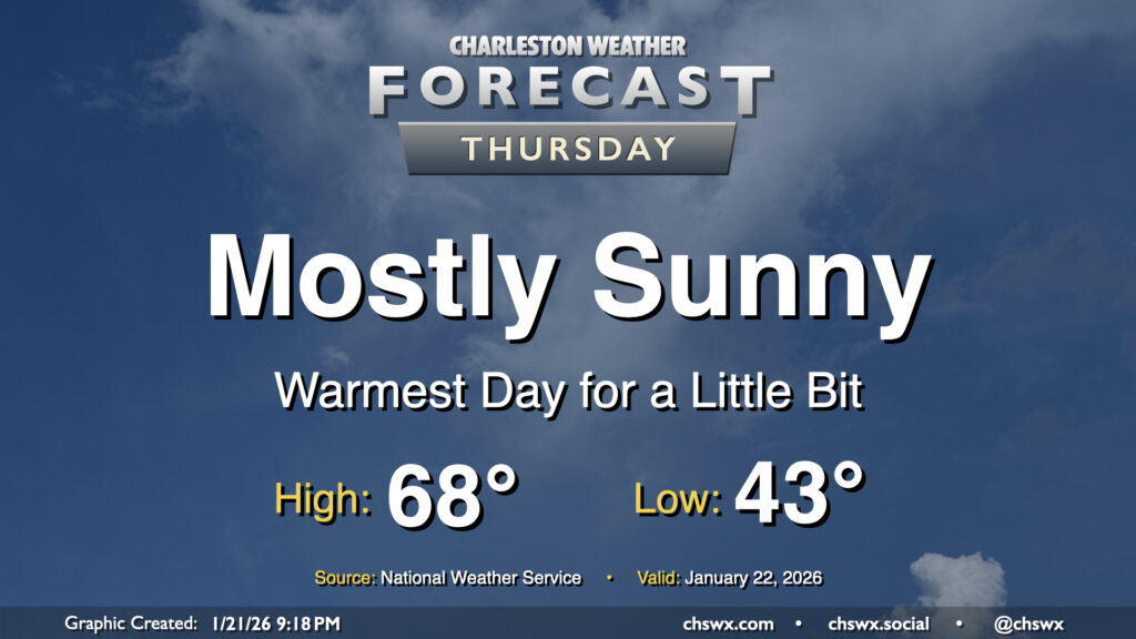
Thursday looks like the nicest day we’ll have for a little while before the well-advertised winter storm system impacts the South, followed by a round of Arctic air to kick off next week. Temperatures Wednesday start in the low to mid-40s — a marked increase from the low of 26° at the airport this morning — before warming to the upper 60s to perhaps even around 70° under mostly sunny skies. Enjoy this — as mentioned, things will start getting stormy and chilly by Saturday.
Friday & the weekend: Weather goes downhill; whether it turns icy is becoming more of a question
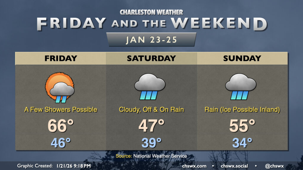
Big changes are in store this weekend as the well-advertised winter storm system affects much of the south, including the Lowcountry.
Friday will be the last 60°+ afternoon we’ll have for the next week as the cold front approaches from the north and northwest, potentially bringing a few showers into the mix especially as we get into the afternoon and evening. That front slides through late Friday, and cold high pressure will build in from the north. As this happens, moisture overrunning the front will start to kick up periods of rainfall for Saturday into Sunday, with the greatest risk of precipitation taking place Sunday evening as low pressure skirts the area to the north. The major question, of course, is just how far south cold air will penetrate. Today’s model guidance has shown a fairly consistent trend back northward with the bulk of the wintry precipitation, and it is possible that many of us may just have a cool, raw, and rainy-at-times Sunday with precipitation departing during the day Monday. That would be ideal; we don’t want or need another Ravalanche, after all. Confidence remains low, though, and it’s gotten to the point where Hurricane Hunters have flown a mission into a piece of energy off the California coast to better sample it, as it is the linchpin for what comes next. This data should flow into the overnight weather models, and we should start to get a clearer picture as far as specific impacts as we get into Thursday and Friday. Until then, it doesn’t hurt to be getting ready for the potential for some ice to disrupt travel, especially for folks in Berkeley and Dorchester in the 17-A corridor and points north and west. And, yes, there are still some credible model solutions that could still bring some ice to the coast, so we’ll need to watch it closely.
After the storm, though, Arctic air will take over, and we will see a few very chilly days that could prompt Cold Weather Advisories. Lows in the teens aren’t out of the question away from the immediate Charleston metro on Tuesday morning, in fact.
Stay informed with trustworthy sources of weather information as we head into the weekend as big changes remain possible over the next couple days.
Follow my Charleston Weather updates on Mastodon, Bluesky, Instagram, Facebook, or directly in a feed reader. Do you like what you see here? Please consider supporting my independent, hype-averse weather journalism and become a supporter on Patreon for a broader look at all things #chswx!