The week ahead: Cooler-than-normal temperatures continue, but no winter weather this week
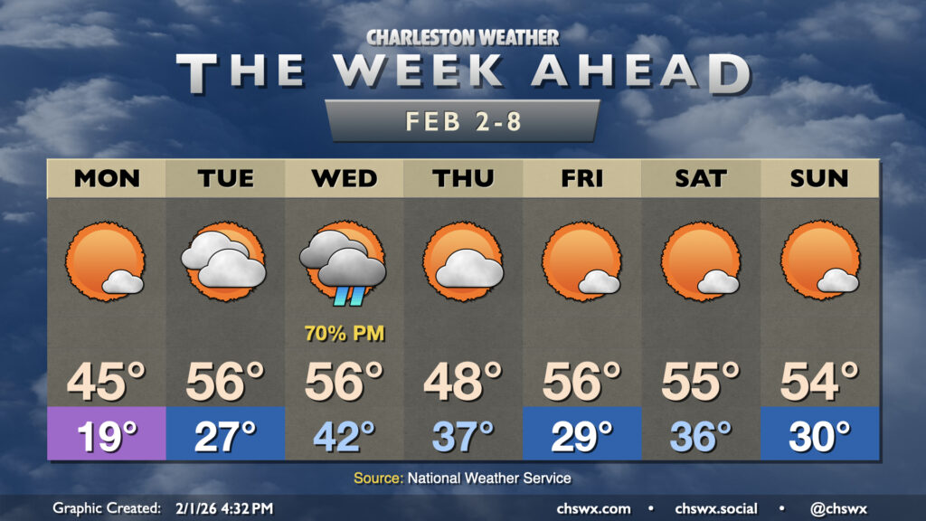
Our run of cooler than normal temperatures that closed January will continue for the first week of February, but a repeat of the past couple weekends of wintry intrigue, mercifully, is not expected.
We do, however, have one more really cold morning in store for Monday as the Arctic airmass remains in place. Clear skies and calmer winds will allow for better radiational cooling overnight, and temperatures should plummet well into the upper teens to low 20s across much of the area as a result. Winds generally around 5 MPH will help push wind chills into the low-to-mid-teens in the morning, prompting a Cold Weather Advisory until 9am. There will be the risk for some black ice on untreated elevated roadways and bridges, but the good news is that main roads (at least what I saw of them) were drying quite nicely today with lots of sunshine. Temperatures head back above freezing by mid-morning Monday, and we’ll peak in the mid-40s in the afternoon. This is still quite chilly, not to mention nearly 15° below normal, but should help melt what’s left of the snowpack.
Temperatures fall back to the upper 20s by Tuesday morning, but Monday’s melting and evaporation should preclude a second morning of widespread black ice concerns. Temperatures will warm significantly over the previous day, heading to the mid-50s in the afternoon with increasing cloud cover ahead of the next cold front. Said front brings showers to the area on Wednesday, particularly in the afternoon and evening based on current timings. This’ll be the only precipitation chance of the week, though. And yes, no concerns for anything other than rain given temperatures staying well above freezing.
Thursday runs a bit cooler in the wake of the front, with lows in the mid-30s warming to just the upper 40s to around 50°. Then, the airmass moderates a bit for Friday with highs jumping to the mid-50s after a start in the upper 20s to around 30°. The weekend, thankfully, looks quiet, with lows in the 30s, highs in the 50s, and generally sunny skies.
Recapping Saturday’s winter weather
Finally, here’s a quick look back at some points from Saturday’s winter storm.
Snowfall
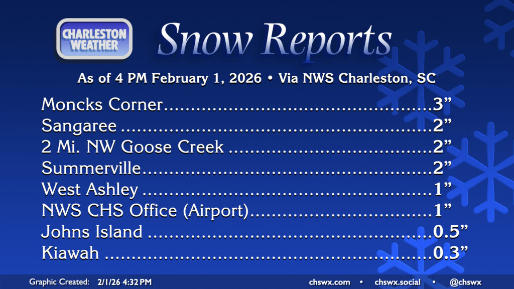
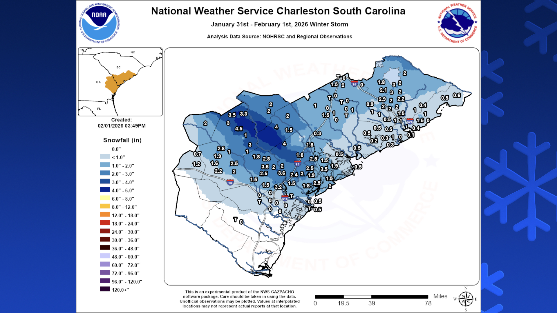
While dry air entrainment put a bit of a damper on our snow totals, overall the mechanics of Saturday’s event were well-forecasted and the event largely played out as expected, especially timing-wise. Snow totals were definitely driven by smaller (mesoscale) banding features; while some spots in Moncks Corner got up to 3″ of snow, Huger barely registered on the scale with 0.5″. Most locations inland of the coast got 1-2″ of snow, while snow was tougher to come by along and east of Highway 17. Further to our southwest along the Savannah River, there were spots that received upwards of 4″ by virtue of being underneath one of the stronger snow bands. So it goes with these things. Even though it might not have been as much fun to play in as the past couple larger snow events on record here, at least the recovery period will be relatively short, with most places back in operation by Monday afternoon (if they didn’t already reopen today).
If you’re interested, the National Weather Service has compiled snow totals from around the Lowcountry and its Georgia counties as well on its website.
A 126-year-old record low falls
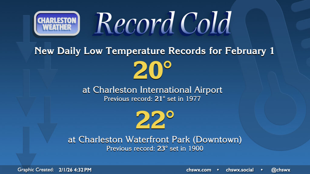
This morning’s bitter cold did, in fact, set new daily records for February 1 at both of the climate sites in the Charleston metro area. The airport dipped to 20°, breaking the record of 21° set in 1977, while downtown Charleston fell to 22°, breaking a 126-year-old record low for the date of 23° set in 1900. These record lows were 20°+ below normal for this point in the year.
As for Monday, Downtown’s record daily low for February 2nd, 17° set in 1917, is likely safe. We may yet at least tie another record at the airport, though; the forecast low of 19° would tie the daily record low last set in 1980.
Follow my Charleston Weather updates on Mastodon, Bluesky, Instagram, Facebook, or directly in a feed reader. Do you like what you see here? Please consider supporting my independent, hype-averse weather journalism and become a supporter on Patreon for a broader look at all things #chswx!