The week ahead: A cool start, but quite the warming trend to follow
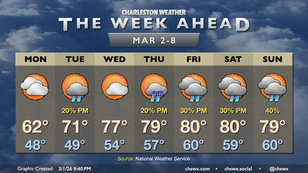
High pressure wedging down from the northeast overnight will set up a cool and mostly cloudy Monday across the Lowcountry — another dip on the temperature rollercoaster after an already up-and-down weekend. Temperatures start in the upper 40s with some fog possible (especially near the coast, where sea fog has been an issue), but the persistent northeast breeze and cloud cover courtesy of some moisture overrunning the wedge will keep temperatures pinned to the low 60s in the afternoon.
The cool wedge of high pressure should break down Tuesday as a trough moves inland. This could generate a few showers, but most of us should stay out of the rain. Lows in the upper 40s warm to the low 70s in the afternoon once the wedge breaks down, and we should see a bit more in the way of sunshine, too.
From there, temperatures look more like May than March, with a stretch of much-warmer-than-normal temperatures that will last through the weekend as Atlantic high pressure is the primary weather feature of note. Temperatures Wednesday soar into the upper 70s, with each day thereafter reaching or flirting with 80°. (The exception will be at the coast, where temperatures should run some 10° cooler due to marine influences.) Dewpoints will also be climbing into the upper 50s to low 60s, so there will be enough moisture for some popup showers each afternoon with the heating of the day, but instability will be limited with ridging aloft nudging in as well.
Finally, we spring forward to Daylight Saving Time on Sunday, ushering in the return of post-7PM sunsets through October 5. Of course, this means we’ve got to put an hour of sleep in escrow until the fall, but I’m sure we will manage. 🙂
Follow my Charleston Weather updates on Mastodon, Bluesky, Instagram, Facebook, or directly in a feed reader. Do you like what you see here? Please consider supporting my independent, hype-averse weather journalism and become a supporter on Patreon for a broader look at all things #chswx!