The week ahead: A cool start, but warming back up
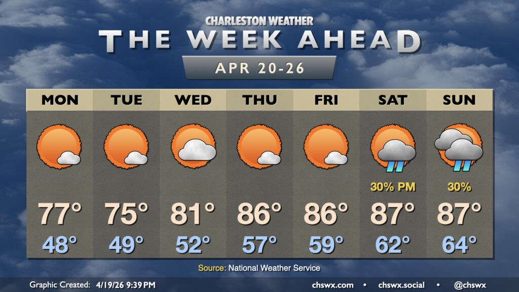
Dry weather continues for the next few days, but we may start to see the pattern begin to flip this weekend to something a little wetter to close out April.
We will start the week on a cooler note in the wake of Sunday’s cold front, with a couple really pleasant spring days on tap. We’ll start Monday and Tuesday in the upper 40s, with temperatures warming to the mid-70s each afternoon with plenty of sunshine as expansive high pressure settles in over the eastern half of the country.
The aforementioned high pressure begins to migrate eastward into the Atlantic on Wednesday, and that will bring us back to the 80s starting Wednesday afternoon. Temperatures will warm back to the mid-to-upper 80s to close out the work week, with a couple more partly cloudy to mostly sunny days ahead.
From there, the dry pattern that has felt inextricable begins to shift a little bit, with the first legitimate rain chances in what feels like forever beginning to tick up for the weekend. While chances are in the slight category for the most part, the improved moisture return around Atlantic high pressure combined with some impulses aloft could stir up some shower activity Saturday afternoon and again on Sunday as a front draws closer. It’s going to take quite a bit of rain to begin to dent this drought, but anything measurable will be welcome at this point. Stay tuned for updates as we get closer to the weekend.
Follow my Charleston Weather updates on Mastodon, Bluesky, Instagram, Facebook, or directly in a feed reader. Do you like what you see here? Please consider supporting my independent, hype-averse weather journalism and become a supporter on Patreon for a broader look at all things #chswx!