The week ahead: Decidedly summertime with afternoon storms and building heat
Heat and humidity will feature prominently in the forecast this week as a more summertime pattern takes hold.
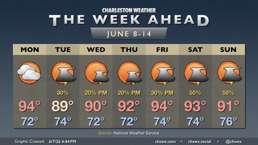
Despite mostly cloudy skies, Monday will be a particularly warm day with the ridge aloft hanging tough while surface high pressure ridges westward from the Atlantic. This will pump in plenty of warm and moist air, and temperatures will head to the mid-90s in the afternoon after starting in the low 70s. Precipitation chances are pretty low in the Charleston metro, though something stray on the seabreeze will be possible, especially as you head closer to I-95.
Daily afternoon thunderstorm chances begin on Tuesday. We’ll have a backdoor front stall and wash out to our northeast on Tuesday, which will help add a little bit of a trigger for afternoon thunderstorms in addition to the seabreeze. It’ll be the “coolest” afternoon of the week, with highs peaking in the upper 80s to around 90°. From there, temperatures begin to turn progressively warmer — 90° on Wednesday, 92° on Thursday, and 94° on Friday. Standard slight afternoon thunderstorm chances will result from isolated popups along and ahead of the seabreeze Wednesday and Thursday.
Ridging loses a little influence as we get into the weekend, which will allow for a little more instability to develop, which in turn will increase the coverage of popup shower and thunderstorm activity along and ahead of the seabreeze in the afternoons starting Friday.
Widespread severe weather is tough to come by during the summers here in Charleston, though lightning makes every thunderstorm dangerous. Brief downpours can cause visibility issues or even some minor urban flooding, and downburst winds in some cases can produce localized wind damage. Not everyone sees a storm every day, with the better chances generally inland of Highway 17 as the seabreeze progresses inland.
Follow my Charleston Weather updates on Mastodon, Bluesky, Instagram, Facebook, or directly in a feed reader. Do you like what you see here? Please consider supporting my independent, hype-averse weather journalism and become a supporter on Patreon for a broader look at all things #chswx!